Tag Archives: walking

Whitecoats: On the Path of the Plague Dogs, Part I

Raven Tor, Levers Hause and Seathwaite Tarn.

In Richard Adams’ 1977 bestseller, Plague Dogs, Rowf and Snitter are two dogs subjected to cruel experiments in a vivisection lab. When an unsecured catch and a loose bit of wire afford a means of escape, they find themselves in the Coniston Fells. Adams describes the landscape in vivid detail, and original editions of the book are illustrated in characteristic part sketch/part map style by one of Lakeland’s greatest apostles. Inspired by the story, I put on my boots and set off on the path of the Plague Dogs.

I’ve never read Watership Down. I was seven when it was published, but it didn’t cross my radar until the film of 1978. By then I was thirteen, and I’d just discovered Black Sabbath. I had long hair and a full-length leather coat from Oxfam, which I thought made me look like Geezer Butler. My mum had a different take. It was only after a year of people telling me the same thing that I came to accept that she might actually be right: the padded shoulders, pinched waist, faux fur collar and the particular arrangement of buttons meant it was unquestionably a woman’s coat, and if it made me look like anyone, it was Bet Lynch.

My teenage tunnel vision dismissed Watership Down as a cartoon about rabbits, soundtracked by Art Garfunkel and clearly aimed at girls; not the sort of thing a pimply, pubescent Prince Of Darkness should be watching, even if he was unknowingly experimenting with cross-dressing.

Eventually, I ditched the coat but never recovered sufficient good sense to read the book or watch the film. Now, at the tender age of fifty-two, I’m desperate to put that right because I’ve been utterly bowled over by The Plague Dogs.

Plague Dogs by Richard Adams

The Plague Dogs was Adams’ third novel. It tells the story of Rowf and Snitter, a big black mongrel and a little fox terrier who escape from a vivisection laboratory and make for the hills. At first, they incur the wrath of local farmers whose sheep they kill in an attempt to stave off starvation, but when an unscrupulous tabloid journalist, with a remit to embarrass the Secretary of State, gets involved, the story snowballs into a national furore, inflamed by an unsubstantiated allegation that the dogs could be carrying the bubonic plague. Questions are asked in the House, and the army is despatched to assassinate our innocent canine heroes.

It’s a rollicking adventure, an emotional rollercoaster and a biting political satire, but it’s also a passionate anti-vivisection statement. The cruelty and utter pointlessness of the procedures beggars belief, yet in his preface, Adams confirms that “every ‘experiment’ described is one which has actually been carried out on animals somewhere”.

It’s not a wholly one-sided picture, however. No sooner do we sense that Stephen Powell, a young scientist at the lab, is becoming increasingly uncomfortable with his work than we learn his young daughter is suffering from a terminal illness. It’s Powell’s desperate hope that animal research will yield a breakthrough before it’s too late to save her.

And yet the experiments are as barbaric as they are futile: Rowf has been subjected to a succession of near drownings, repeatedly submerged in a tank of water and only revived once he goes limp and sinks to the bottom. He has never known men other than the “whitecoats”. Despite his traumatic experiences at their latex-sheathed, disinfected hands, he still wants to be a good dog and please his masters; but he can’t face another day in the immersion tank. Snitter’s story is even sadder as he remembers a blissfully happy home life before his beloved master was knocked down by a lorry—an accident for which Snitter blames himself. The details are incoherent because the whitecoats have cut open Snitter’s head and rewired his brain to confuse the subjective and the objective. As a result, he suffers disorienting confusion and bouts of vivid hallucination. In his lucid moments, however, he’s smart. Smart enough to notice an unsecured catch and a loose bit of wire. Smart enough to figure out how he and Rowf might escape. When they do, it’s into a landscape very familiar to lovers of Lakeland.

The real Lawson Park was a remote fell farm on the eastern bank of Coniston Water; now it’s an artists’ retreat, run by Grisedale Arts. Never in reality has it been any sort of research lab, but it’s the fictional location of Animal Research (Scientific and Experimental), A.R.S.E. for short—the setting for Rowf and Snitter’s inhumane treatment in the interests of science. When they make a break for hills, they find themselves in the Coniston Fells, which Adams renders in rich detail.

Coniston Fells
Coniston Fells

My friend, Gillian, grew up in Coniston and suggested I should read the book for this very reason. “You could walk the routes and write about it in your blog”, she said. It sounded a fine idea, so I searched for The Plague Dogs on Amazon. I was one click away from buying the current paperback, when a customer review caught my eye.

“Before buying a copy of The Plague Dogs I took out a request from the library and ended up with an older edition. It was a wonderful hardback – the illustrations of the Lake District by the late Alfred Wainwright complimented Adams’ rich, vivid prose perfectly. Sadly though, the illustrations have been removed from this recent (2015) re-issue.”

The original hardback was illustrated by Wainwright? This was the edition I had to have. Google found me a second-hand copy for £1 + £3.99 p&p. It arrived two days later, and it looked wonderful. As well as hatched pencil drawings of the fells, there were eight characteristic route maps, rendered in the same part sketch, part map style, familiar to readers of AW’s Pictorial Guides. Indeed, for Wainwright fans, the book is a welcome supplement.

Page 46
Page 46

Wainwright was also an ardent anti-vivisectionist, and Adams says in the preface, “I seriously doubt whether an author can ever have received more generous help and co-operation from an illustrator”.

It’s in the early hours of a crisp autumn morning that Rowf and Snitter make good their escape. As the sun rises, they find themselves on the wild expanse of Monk Coniston Moor. Snitter is appalled. What have the men done? “They’ve taken everything away, Rowf—the roads, cars, pavements, dustbins, gutters—the lot. How can they have done it?”

The pair head down hill, cross the road and trot along the shore of Coniston Water. Here, Snitter is entranced by how still everything looks beneath the surface. Would his racing mind be as calm if he was in there? Rowf is terrified of the water, however, and remonstrates with his friend not to go in. “You can’t imagine what it’s like”.

Monk Coniston Jetty
Monk Coniston Jetty
Coniston Water
Coniston Water

Buoyed up by the sight of houses in the distance, the fugitives head along the road to Coniston village, but Snitter is overcome by one of his turns and has to lie down. A car stops, and two men get out to help, but when they try to pick Snitter up, Rowf assumes they are trying to recapture him and return him to the lab. He springs forward in attack and frees his friend, and the pair run for the village.

Coniston village
Coniston village

Rowf is understandably wary of men, but Snitter knows they’re not all like the whitecoats. On the streets of Coniston, he remembers shops. In his former life, these were places where people made a fuss of you and gave you treats. They try their luck in a butchers’ shop. The friendly but fastidious proprietor comes over. He means no harm and crouches to greet them, but his hands smell of disinfectant, he’s carrying a knife, and a pair of scissors protrude from the pocket of his WHITE COAT.

The two dogs flee up the walled lane beyond The Black Bull and out into the Coppermines Valley. On page 46, Wainwright documents their route, and on a bright November morning, this is where I pick up the trail.

Track to Coppermines Valley
Church Beck
Church Beck
Track to Coppermines Valley

Above Miners’ Bridge, the Old Man, Brim Fell, Swirl How and Wetherlam are ablaze, lit orange and blue in the first light of morning, just as Adams describes. I follow the track beside Low Water Beck to the Youth Hostel. Here I pause to check the map and imagine the scene. As I do, I hear a faint patter and something soft brushes my leg. It’s a black dog. After a startled double take, I make friends with an excitable border collie, who can’t hang about because he’s just spotted a big stick. His loving owners are laughing as they catch us up, “that’ll be the first of many, today”, the woman grins. Proper masters, as Snitter might say.

Miners' Bridge
Miners’ Bridge

Church Beck waterfall
Border Collie, Coniston Youth Hostel
Rowf?

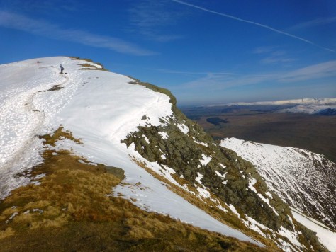
The main track swings right along the lower slopes of the Black Sails ridge, but I turn left towards the quarry, its marbled face, a dark daubed cubist canvas below the tufts of russet scrub. The road is blocked by a gate. It’s padlocked, but perhaps only to vehicles. Beyond, the word “Footpath” has been scrawled on a slate. I climb the bars and start up the faint grassy trod to which it points. Above the spoil heaps, I join the path from Crowberry Haws. Two slate cairns stand guard, and a Herdwick grazes unperturbed.

Quarry, Coppermines Valley
Wetherlam from Boulder Valley

I cross the footbridge into Boulder Valley and pause by the Pudding Stone. The path continues to Levers Water, but immediately above, Brim Fell towers, craggy and intimidating. Anxious to escape the reach of man, it’s up these steep slopes that Rowf and Snitter start. I feel duty-bound to follow, although perhaps not strictly in their paw steps. They have me at a disadvantage: for one, they’re dogs—replete with four legs and a low centre of gravity; and two, they’re fictional, so they have the intrinsic power to do whatever Adams’ imagination invents. He has them climbing on the line of Low Water Beck, clambering up its boulders, skirting its shallow falls and splashing through its brown pools. His co-conspirator, Wainwright, plots the path. But from where I’m standing, the beck is an angry cascade, crashing down a severe ravine. I see no way up for a meagre middle-aged mortal.

Low Water Beck ravine

In his Pictorial Guide, Wainwright advocates a mildly more man-friendly route, which climbs a grassy rake on the opposite side of the crag. I detect what might be a path leading to the crag’s foot. It proves something of a mirage, and I’m quickly off piste, but I track around the bottom of the rocks toward the strip of mossy green. A brief scramble provides a short-cut, and soon I’m clambering up steep and slippery grass. It’s hard going, requiring hands and feet, and I can see why AW advises against it for descent. But it’s not far from the beck, so I feel I’m being as true as I can to the plot, and besides, I’ve always wanted to try this ascent, AW promises it furnishes a fuller understanding of the fell’s true structure.

Simon's Nick, Coppermines Valley
Simon’s Nick, Coppermines Valley

I reach an old mine level, where the curled ends of rail tracks protrude like vestigial limbs. Here a path of sorts emerges; it’s a steep rocky staircase, skirting a river of loose stone, but the going is firmer than before, if no kinder on the calves. Eventually, the gradient relents, and I’m confronted with a vision that fills Rowf with dread—the limpid corrie tarn of Low Water, a pool of primeval tranquility, a dark oasis of serenity below the plunging slopes of the Old Man, but to poor traumatised Rowf, a huge, menacing immersion tank.  He races away up the slope to the summit of Raven Tor. I sip coffee, catch my breath, and just as Snitter does, I follow.

Looking back down from Brill Fell ascent
Raven Tor
Raven Tor

Beyond the summit, the ground drops abruptly to Levers Water. Strangely, despite its larger size, the tarn holds no fresh dread for Rowf. It’s just as well because Snitter spots a line of sheep by the western shore. They’re being pursued by two border collies and a man. The man is whistling and calling to the dogs, encouraging them to chase the sheep, and the dogs are listening and responding. Man and dog, working as a team. Here at last is a proper master. All he and Rowf have to do now is bound down the fell side and join in. If they chase the sheep too, perhaps the man will give them a home, and food, and a happy life away from the whitecoats.

Levers Water from Raven Tor

My descent is more circumspect. The slopes below the col look precipitous. In his Pictorial Guide, AW shows a route beside Cove Beck. I follow a narrow trod over the spine of Gill Cove Crag, in the shadow of Brim Fell’s summit, and as the contours diverge, I descend through increasingly soggy ground. Eventually, I hear the sound of running water, and the beck appears, a narrow scar trickling elusively through scrubby moorland.

Beyond, a cairn marks the path up to Levers Hause. Between here and the waterline, Rowf and Snitter make their ill-fated attempt to gain a master by chasing his sheep. Luckily, his sheep dogs reach them first and vent their anger in broad Cumbrian:

“Art out of the minds, chasing yows oop an’ down fell, snappin’ an’ bitin’?”, fumes one. “Wheer’s thy farm at? Wheer’s thy master?”.

When Snitter explains, “we haven’t a master. We want to meet yours”, the answer is unequivocal: “He’ll fill thee wi’ lead”.

I turn and follow the forlorn fugitives’ escape route up steep rocky steps to Levers Hause. Here, the dogs ruefully acknowledge they’ll find no welcome in the world of men. They must become wild animals. Still stoked from the chase, Rowf attacks a mountain ewe. He makes the kill, but takes a fair battering in the process. With his hunger satiated, exhaustion takes hold, and the big black mongrel lies down in the bog myrtle to nurse his injuries. Meanwhile, Snitter despairs at the bleakness of their prospects. As his synapses start to misfire, he scampers down the steep slopes to the Duddon Valley in a firestorm of neurotic confusion.

Levers Water from Levers Hause path

A right of way runs from Levers Hause to the far shore of Seathwaite Tarn. Or at least it does on the map. There’s little sign of a path on the ground, and the gradient is frightening. I’d have to be as mad as Snitter to attempt it, and yet somehow, I do. I climb down a little way to test the going, stepping sideways from grassy tuft to stony shelf. Emboldened, I soldier on. Part way down, I imagine a path, but it’s just a loose spray of scree, too shallow to offer much support. Zigzagging avoids the severest sections, and earlier than I’d reckoned, I’m approaching the tumbling waters of Tarn Beck.  Here, the ground grows marshy; the valley bottom is a quagmire, red with reed beds as it reaches out to Seathwaite reservoir. I keep to a contour to stay out of the worst. The sun is streaming over Dow Crag, bleaching the fell sides and blinding me with its glare.

Seathwaite Tarn from Levers Hause
Tarn Beck
Duddon Valley and Seathwaite Tarn

Here, Snitter does what I decline to do. Lured by the fevered machinations of his scrambled mind, he breaches the beck and splashes through the boggy ground on the other side. The kindly man in the brown tweed coat that he imagined was there is an illusion, but as the fit passes and the world comes back into focus, he spots something else. Something welcome. Something real. Just shy of the reservoir he finds a small spoil heap:

“On top was a levelled space of turf and small stones, perhaps half the size of a lawn tennis court. It was completely empty, but on the further side, where Great Blake Rigg, the south face of Grey Friar, rises like a wall was a symmetrical, dark opening, lined and arched with stones”.

I’m looking at it now (through binoculars).  It’s an old level of Seathwaite copper mine, and in the book, it becomes a temporary home for Rowf and Snitter. Here, they meet the tod, a wily fox, well-versed in the ways of the wild.  His savvy, calculating instinct for self-preservation contrasts markedly with the dogs’ innocent loyalty. He’s appalled by their naivety and sees them as a liability, likely to draw the attention of farmers and their shotguns. Yet, in Rowf he also sees a valuable asset: there’s not many a wild Lakeland beast can bring down a full-grown ewe.  The dogs might have their uses after all, and an uneasy alliance is formed.

Rowf and Snitter's new home

Rowf and Snitter’s new home

Short winter daylight hours dictate that here, for now, I must take my leave. But as I make the day’s last ascent out of lonely Dunnerdale and up to Goat Hawse, the peace is broken by an alarming bark, fuelled with feral bloodlust. A chilling chorus of murderous howls swells into an amplified echo, and on the lower slopes of Grey Friar, I make out a swarm of white dots moving fast across the fell.  With binoculars comes comprehension: fuzzy points resolve into a pack of foxhounds. They’re coursing an aniseed trail. It’s profoundly unsettling because it’s a scene straight from the book. In all my years on the fells, I’ve never witnessed this, yet later in the story, Snitter sees the self-same thing.  Only this time, it’s not aniseed they’re hunting… it’s the tod.

To be continued…

Read the second part of my journey along the path of the Plague Dogs here:

Here’s where the story ends


    Enjoyed this post?

    Like to receive free email alerts when new posts are published?

    Leave your name and email and we'll keep you in the loop. This won't be more than once or twice a month. Alternatively, follow this blog on Facebook by "Liking" our page at https://www.facebook.com/lakelandwalkingtales

    The Beauty of Buttermere

    Rannerdale, Black Sail, Haystacks & High Stile

    Buttermere is a valley of astounding natural beauty. A journey around its hills and hostelries uncovers stories of Dark Age battles, confidence tricksters and a shepherdess whose face and misfortune wooed the nation.

    “I’m sure it’s her”, says Tim emphatically. We’re intently watching a girl swim across Crummock Water. This isn’t as lecherous as it might sound: we’re on the summit of Rannerdale Knotts, so she’s far enough away to render any essential features scarcely discernible. Indeed, the idea that she’s a “she” is, at best, wildly speculative, which does kind of call into question Tim’s sudden conviction that she’s the author of a wild swimming blog he’s been reading.

    “How do you know?” I ask.

    “She has a trademark orange toe float”, he explains.

    She is indeed trailing something orange. I get the concept of a water-tight container in which to put your keys, phone, flip flops, T shirt and shorts, but why on earth would you tie it to your toe? Evidently, I think this out loud.

    “TOW float, duck egg!”, exclaims Tim, in disbelief. “T.O.W. as in something you tow behind you, not something you tie to your toe.”

    (Ever wished you’d thought it through before asking a question?)

    Crummock Water from Rannerdale Knotts
    Crummock Water from Rannerdale Knotts

    In spring, Rannerdale Knotts is famed for the abundant bluebells that carpet its flanks. It’s also supposed to be the scene of an epic battle, where indigenous Celts and Norse settlers joined forces to see off the invading Normans. According to legend, the bluebells sprang from blood of the vanquished. Now, in August, they’re long gone, replaced with ubiquitous bracken, but the colossal mountain backdrop of Grasmoor, emerging from cloud, is enough to inspire visions of Valhalla.

    Grasmoor from Rannerdale Knotts
    Grasmoor from Rannerdale Knotts

    Dark age warriors are centuries departed, but a Herdwick lamb peeks over the crenellations of a little rock tower, looking every bit the king of the castle. According to one theory, the Herdwicks came over with the Vikings, so perhaps this one’s guarding the top against marauding French ewes like Charmoise or Charollais. I can’t speak for Tim’s lineage but my Dad’s forays into family history suggest ours was a Viking name. The lamb regards us with relaxed indifference; perhaps he senses a common bloodline.

    Herdy Lamb on Rannerdale Knotts
    Herdy Lamb on Rannerdale Knotts

    It’s late Thursday afternoon. We arrived in Buttermere as the rain stopped and took advantage of brightening horizons to climb up here. The air is seldom sweeter than after rain, and as the emerging sun vaporises the damp, this exquisitely beautiful valley works profound enchantments.

    A couple of hours later we’re sitting outside the Fish Inn. In Wordsworth’s time the pub was home to Mary Robinson. A shepherdess and muse to the Romantic poets, this landlord’s daughter was known as the Beauty of Buttermere. Writer and journalist, Joseph Budworth described her thus: “her face was a fine oval face, with full eyes and lips as sweet as vermillion”, (which is a bit strong, given she was only fifteen at the time).

    Budsworth’s words made Mary famous, and men came from far and wide to set eyes on her. By the time she was twenty-five, she’d attracted the attention of a dashing aristocratic colonel by the name of the Augustus Hope. Hope swept Mary off her feet with a proposal of marriage, which she gladly accepted.

    All was not as it seemed, however. When Coleridge waxed lyrical about the wedding in a London newspaper, friends of the real Augustus Hope, unmasked Mary’s husband as an impostor. In reality, he was James Hatfield, a confidence trickster and bigamist, already wanted in connection with a string of thefts and forged cheques.

    Hatfield fled to Wales, where he was apprehended, then convicted and hanged in Carlisle, leaving Mary with a baby that tragically died of pneumonia. But her story tugged at the nation’s heartstrings, and Mary was crowdfunded out of hardship; she later happily married a Caldbeck farmer.

    It’s not the Beauty of Buttermere that’s fanning the ardour of the stag party at the next table, it’s Ursula Andress. They’re all getting misty-eyed and nostalgic about “that scene” in Dr. No, where she emerges from the waves in “that bikini”. All bar one that is. The young lad at the end, who’s half their age, has no idea who they’re on about. He has to endure a round of hectoring on how he has missed out in life, and he resigns himself to making do with his generation’s Bond movie equivalent—Daniel Craig in budgie-smugglers.

    Up the road in the Bridge Inn, It’s a dog that stealing hearts. A beautiful, big (and I mean BIG) Gordon setter, who’s brought his own blanket and dragged it under a table barely large enough to accommodate him. He now lies napping to the universal dotage of the bar.

    Back at the Buttermere Youth Hostel (our home for the night), we sit outside on a wooden bench, sharing a hip flask of single malt with some young Scottish lads. They’re on a road trip around the north of England. As night falls over the water, and nothing but the distant sound of waterfalls and the occasional hoot of a Herdwick disturbs the tranquility, they don’t take much persuading to abandon tomorrow’s trip to Hadrian’s Wall and spend another day in heavenly Buttermere.

    We awake to heavy rain, but heartened by an improving forecast, we resolve to wile away a lazy morning in the village. We decamp from the hostel to Croft House Farm Cafe for cake and the finest wines known to humanity (well coffee at any rate). Outside, amid the procession of wet people, the Gordon setter from the Bridge drags his owner along the pavement.

    Around lunchtime, we wander up to the church, not sure whether the rain is really easing or if it’s just our wishful thinking. Inside, a small plaque in the window commemorates the surrounding fells’ greatest apostle, Alfred Wainwright. The inscription invites us to raise our eyes to Haystacks, where his ashes lie. As we do, the rain stops.

    Haystacks from High Crag
    Haystacks from High Crag

    We’re staying at the Black Sail Hut tonight. Once an old shepherd’s bothy, it’s now England’s remotest Youth Hostel, tucked away in the wildest corner of neighbouring Ennerdale. With the forecast holding good, we’ll take in Haystacks en route.

    We grab our rucksacks and head down to the waterline and the path that tracks the south-western shore, under the wooded lower slopes of Red Pike and High Stile. In the warm humidity, with low cloud wisps hugging the fells, Buttermere assumes a tropical demeanour. After weeks of drought, the downpours have brought forth a multitude of green, the air vital with the scent of fresh growth. The cloud rises above fell tops, and bands of purple heather colour their upper contours. Ahead, the plunging profile of Fleetwith Edge emerges teasingly by degrees: mists disperse to reveal a daunting ridge, resplendent in precipitous drama. Buttermere, becalmed, is a platinum mirror, a fuzzy-edged reflection of everything above.

    Buttermere
    High Snockrigg over Buttermere
    High Snockrigg over Buttermere
    Fleetwith Pike
    Fleetwith Pike
    Buttermere reflections
    Buttermere reflections

    When we reach the water’s end, we follow the stream to Gatesgarth farm and track around the nose of Fleetwith Pike to find the path that climbs from Warnscale Bottom.

    I lose Tim momentarily as he stops to admire a dry-stone wall. This is becoming a regular occurrence. Tim lives in Sheffield and does occasional work for a friend who runs a walling business. He’s developing an artisan’s eye for craftsmanship. He tells me the Human League’s Phil Oakey is often to be seen about the city, looking every bit the country gent in immaculate tweeds walking immaculately groomed dogs, but Tim’s boss has come to dread their encounters. Not that Oakey isn’t friendly and convivial, quite the opposite, he’s just so interested in the art of walling, he’ll talk so long and ask so many questions that it’s impossible to get any work done. This plays out in my head like a Viz cartoon: “Oh no, it’s Phil Oakey”—wallers with deadlines diving for cover behind their half-laid structures as a rueful Phil saunters by, singing Don’t You Want Me Baby.

    The path climbs steadily above Warnscale Beck. Across the stream, Haystacks’ northern face is a sheer wall of crag. Height brings fresh perspectives on Buttermere below, molten silver now as a blanket of cloud hangs above. In the distance, arcing right, Crummock Water glistens under brighter skies pregnant with promise.

    Buttermere the from path to Dubs Bottom
    Buttermere the from path to Dubs Bottom

    False promise as it turns out. By the time we reach Dubs Bottom it’s mizzling. We shelter in Dubs Hut bothy to see if it blows over, but as the drizzle sets in, we retrieve waterproofs and juggle layers to affect a balance between dryness and heat exhaustion. Then we head out.

    The stream is in spate and the crossing at the ford, precarious. An enterprising soul has turned a narrow plank into a makeshift bridge and we try our luck on it. It’s something of a balancing act, being so thin and bending worryingly in the middle. Once across, we climb through the crags into cloud.

    Today, Innominate Tarn is a scene from Arthurian legend, its solemn waters evaporating into mist. This is where Wainwright’s ashes were scattered, and we pause to pay our respects. In the murk, this most beguiling of fells has its other treasures well-hidden. We strike out for the summit but peak too early (literally), and with the fog thickening, it seems sensible to head down. Discernible landmarks recrystallise as we approach Scarth Gap, and by the time we reach Black Sail Hut, the rain has stopped and there’s a hint of sun.

    We’ve stayed twice before, and I’ve blogged about each visit. The first, A Walk on the Wild Side, starts at Wastwater and recalls the murder of Margaret Hodge, dubbed The Lady in The Lake by the press, when her body was discovered by a diver. The second, Back to Black Sail, riffs on the close resemblance of one of our fellow guests to Danny, the drug dealer from Withnail and I. James, the warden, greets us like old friends and reveals he’s been reading the posts.

    “You’re not detectives, are you?”, he asks with a smile. “There’s always a murder or something nefarious”. He glances at the register, “I’ve put you down as Sheffield and Steel”.

    Tim heads off for a shower. I buy a nice cold beer and take it outside, where two parties of women are already basking in the peace and disarming beauty of valley. One lot are from Whitley Bay and full of stories of the Northumbrian trails. The others are up from Kent for a weekend “off grid”. I can see from their faces, Ennerdale is already working its magic.

    They’re also two Proseccos in, so when Tim emerges from shower in nothing but a skimpy towel, he has to run a gauntlet of wolf whistles. (Move over Daniel Craig). Tim dives for the sanctuary of the men’s dorm and meets Dermot, a lovely guy who’s walked over from Borrowdale by way of Sty Head.

    Over supper and a few drinks, the conversation flows easily. There’s much laughter and much discussion of tomorrow’s plans. Most of us are heading for Buttermere via routes of varying ambition.

    When he finishes his shift, James joins us for a drink and we learn that he grew up round here, went off to university, but came back— so strong was the lure of the valley. Working with people and keeping this close to nature is his ideal. He speaks with such passion about the landscape and the wildlife. He talks about stumbling upon abandoned SAS camps: the SAS conduct field training here, and when they make a camp, they construct fantastic windbreaks from woven branches—a lucky find for walkers or wild campers. Take note, however: if an iron tripod is still in place over the fire ashes, it means they’re coming back. James is sure he must spend hours in their crosshairs when they’re conducting sniper training.

    In the morning, I write in the visitors’ book, “That concludes our enquiries for now, but further investigations will be necessary—Sheffield and Steel”.

    We step out into sunshine and head up to Scarth Gap. Near the top, we catch up with the party from Kent. They’re staying another night and plan to spend the day exploring Buttermere. As we exchange goodbyes, June, the chief wolf-whistler, says earnestly, “Last night was so nice, I really hope the conversation this evening is as convivial”. A little further on we bump into Kathryn, a friend of mine, who says she’s just seen a group of teenagers heading for Black Sail with a massive ghetto blaster, blaring out bass-heavy beats and auto-tuned inanities. Oh no. I’m sorry, June.

    We’re heading for Buttermere too, over the High Stile range, but with a clear sky above, we’re compelled to revisit Haystacks first. The summit is not so coy about revealing its riches today, and we join a procession of pilgrims all scrambling up its stony paths to wander  around its heather-clad plateaux, climb its rocky turrets and linger by its glistening tarns. Across Ennerdale, Pillar is a redoubtable giant, thrusting forward a muscular shoulder; over Warnscale, Fleetwith Pike and Dale Head wear matching cloaks of purple and viridian.

    Pillar
    Pillar

    Buttermere is deep metallic blue as we return to the col, shadowed by the waves of cloud rolling over High Crag. As we reach Scarth Gap, they clear, revealing High Crag’s sheer pyramidal profile.  There’s no other way up but straight. It’s a relentless slog, but strangely exhilarating. We get into an impromptu relay with a Geordie couple as we take turns at pressing on and pausing to rest. At the top, the views rob what little breath the ascent has left us.

    Buttermere from Haystacks
    Buttermere from Haystacks
    High Crag
    High Crag

    Ahead, the higher summit of High Stile is crowned with cotton wool. As we approach, we climb into the cloud. It’s thin and wispy and not as oppressive as yesterday, but still a tad disorienting.  In the gloom, we meet a couple who have lost their bearings. Like us, they’re aiming for Red Pike, but they’re walking back towards High Crag.  We check the map and take a compass bearing, and all set off together in what we hope is the right direction.  We find reassurance in a line of cairns, and as we start to descend from High Stile’s summit, the cloud lifts and Red Pike lies before us. The way as far as the summit is easy, but the descent to Bleaberry Tarn drops down loose scree as steep as the slopes of High Crag. It’s not without its thrills, but it’s still a relief to reach the water’s edge, and we sit awhile, watching the ripples lap the rocks.

    Buttermere from Red Pike
    Buttermere from Red Pike

    A succession of walkers passes us, then we notice someone waving.  It’s Dermot.  He’d been thinking of walking over Brandreth and Fleetwith Pike to Honister, then ascending Dale Head and wending his way back to Buttermere over Robinson and High Snockrigg. In the sober light of morning, he clipped his ambition and basically followed our route, but ascended Haystacks from the back, via the Coast to Coast route that climbs to the col with Brandreth.  It’s great to see him again. He joins us by the shore, and after a while, we make the descent to Buttermere together. On the way down we discover Dermot was at university in Sheffield.  He asks about all his favourite haunts, and Tim updates him on which are long gone, which have changed beyond recognition and which are still much the same.  We swap walking stories, marvel at the magnificence of Buttermere and Crummock Water and plan new adventures: Fleetwith Pike, The Newlands fells, Mellbreak, Ard Crags, Whiteless Pike and Grasmoor.

    Buttermere and Fleetwith Pike
    Buttermere and Fleetwith Pike

    Below Grasmoor, lies Rannerdale Knotts. In six or seven months, it will be blue with flowers budded on the blood of fallen Normans. When you gaze on the utter beauty of this valley, it’s no mystery the Celts fought so fiercely to defend it.

    Cumbria was one of the last strongholds of the Ancient Britons. When the kingdom eventually fell to the waves of European invaders, many of its Celtic poets, chieftains and churchmen fled to Wales. And England became England. Angleterre: land of the Angles (German) and the Saxons (German), and later, the Vikings (Scandinavian) and the Normans (French).

    Grasmoor and Rannerdale Knotts
    Grasmoor and Rannerdale Knotts

    Which, I suppose, begs the question: does the truly hard-line position on freeing ourselves from Europe and regaining our sovereignty mean kicking us English out of England and giving it back to Wales?

    Rees-Mogg’s a decidedly Welsh-sounding name, don’t you think?


      Enjoyed this post?

      Like to receive free email alerts when new posts are published?

      Leave your name and email and we'll keep you in the loop. This won't be more than once or twice a month. Alternatively, follow this blog on Facebook by "Liking" our page at https://www.facebook.com/lakelandwalkingtales

      The Deer Hunter

      The Nab & the Rut

      In Martindale, it’s antlers at dawn as Britain’s largest land mammals fight for the right to party, and I pay a tribute to a sly old fox for inspiring me to walk The Far Eastern Fells.

      On a chilly October morning, Ullswater is the colour of cold steel, ridged with dark ripples where it laps the jetty, a moody pool, carved from the frozen earth by a river of ice, and a keeper of mysteries. A small huddle of pilgrims has gathered on the pier at Glenridding, ready to set sail across its brooding waters in search of an ancient rite.

      Ullswater Steamer
      Ullswater Steamer

      The red deer is the largest British land mammal; stags stand well over a metre at the shoulder and weigh up to 190Kg.  11,000 years ago, they came to Britain from Europe, and their meat, hides and antlers provided Mesolithic man with an important source of food, clothing and tools. With the advent of agriculture, much of their natural habitat was lost, and they disappeared from many parts of England, but they remained well-established in Scotland. The Victorians bolstered the population by cross-breeding them with wapiti and sika; numbers and distribution have increased ever since, but some pure-bred red deer herds still remain in England.  The oldest inhabits the Martindale Deer Forest, which is maintained by the Dalemain estate as a sanctuary.

      Autumn brings the breeding season, known as the rut. Between September and November, stags return to the females’ territory and do battle for the right to mate.  It’s a winner takes all scenario, so testosterone levels run high. The victor gets to sow his seed throughout the herd, while the losers spend a celibate year drooling over pictures of pretty hinds, pouting provocatively from the pages of The National Geographic, distributed by gamekeepers to maintain their interest and prevent them from taking up alternative hobbies like stamp collecting or computer games. During the rut, the males establish dominance by roaring and strutting like Steve Tyler on steroids; but if that doesn’t work, they fight—sometimes, to the death.

      The Deer Forest isn’t accessible without specific permission from the estate. Luckily, we’re on a special expedition arranged by the RSPB in conjunction with Ullswater Steamers, so clearance has been granted. As we board the steamer, I realise we’re a motley crew, clad in autumnal hides of microfleece and Gore-Tex; dominance appears to be established not by the size of antlers but by who has the biggest binoculars. And I’ve forgotten mine, so I’m already at the bottom of the pecking order.

      As the steamer glides over primordial waters, the world of concrete and tarmac dissolves. An isolated shaft of sun embroids a bright golden braid on the sombre fell side below Helvellyn, and a sense that we’re venturing somewhere older, wilder, more primal pervades.

      Ullswater
      Ullswater

      On the heather-clad slopes below Place Fell, belted Galloways graze; then a ripple of excitement runs through the boat as pair of antlers appears on the skyline. A slender stag makes a fleeting appearance.  He’s only young—too small to entertain serious hopes of quenching his ardour this year.

      Galloways and young stag
      Galloways and young stag

      An RSPB steward directs our attention to the crags above.  He’s spotted a peregrine. Massed ranks of binoculars are raised in unison.  My wife, Sandy, a professional photographer, aims a long telescopic lens. I fumble with the zoom on my little compact camera in an effort to join in. It comes as no surprise to anyone that I fail to spot it.  The steward takes pity and lends me his eyeglasses. As a flock of ravens appears, he explains peregrines and ravens are arch-enemies. They compete for the same eyries, and ravens will often join forces to mob an invading falcon.  I see an opportunity to improve my standing within the group as I’ve actually witnessed this.  I recount standing on the summit of High Street, not far from the trig point, and hearing a raucous squawking overhead.  I looked up to see a peregrine pulling ahead of pursuant mob of angry ravens, all apparently vying to peck at its tail feathers. The peregrine was much faster, and in a few wingbeats had gained a good lead, but just as I thought the action was over, it did something I wasn’t expecting. With a dazzling display of aerobatic agility, it performed a tumble-turn and sped back, like an Exocet missile, straight at the unfortunate raven it had ear-marked as victim. The ravens dispersed instantly, the target only just getting out of the way in time.

      The steward nods knowingly. “Quite a spectacle that, isn’t it?”, he says with a grin. “I’ve seen it where the raven didn’t get away. It ended in a sickening thud and a flurry of black feathers.”

      Ullswater shoreline
      Ullswater shoreline
      Howtown
      Howtown

      We disembark in Howtown, where a minibus awaits to ferry us up the hill to a track below Beda Fell, where three more stewards have set up telescopes: one pointing up the slope, and one pointing across to The Nab.  I wait my turn on the latter. When it comes free, the steward directs my gaze to the lower slope where a large herd of hinds is encamped.  It’s all very laid back: they’re lying down, basking in the autumn sunshine (or at least they would be, if there was any).  The resident stag sits smugly amid his harem, awaiting challengers. He doesn’t seem overly concerned—probably because he’s the cervine equivalent of Arnold Schwarzenegger, a huge muscular brute with a formidable pair of antlers.  Up wind, on the other side of a broken-down wall, are two young hopefuls. They’re recumbent too, desperate to keep out of Arnie’s sight while they summon the courage to take him on.  I wouldn’t bet on that happening any time soon.

      As we chat, the steward tells me they’ve be running these excursions for a few years. It hasn’t always gone to plan…

      Since we wiped out the wolves and bears that once roamed our forests, the red deer have no natural predators. If left unchecked, their numbers would grow unnaturally large, and the health of the herd would suffer. As a consequence, some culling is necessary. It’s a fact that doesn’t sit well with those of a sensitive disposition, but on balance, having the free run of Martindale and taking your chances, occasionally, with a skilled gamekeeper armed with a rifle and a remit to reduce numbers by removing the weakest, sounds a better deal to me than being cooped up on an intensive farm, then being shipped to the abattoir. I don’t know whether the Dalemain Estate offers paying clientele the opportunity to shoot deer for sport, and quite why anyone would take pleasure in killing such magnificent creatures is utterly beyond me.  I have no issue with humane culling, or with killing animals to eat, but if I had to do it, I’d be choking back the tears.

      …As such, I can fully imagine the horror of the nature lovers who took this trip, a year or two back, and heard shots, then had to stand aside for an estate quad bike towing the blood-spattered carcass of a hind.  (Consequent discussions between the estate and the RSPB have resulted in a less distressing coordination of activities.)

      It’s all hotting up on Beda Fell where another herd is grazing. Their stag is similarly reposed, but perhaps, not for long. A young contender has appeared on the skyline. He’s sniffing the air and assessing the situation. I take my turn on the telescope. A girl in an RSPB jacket asks me if I have an iPhone. She explains it’s possible to point your phone’s camera at the telescope’s eyepiece and get a reasonable close-up picture. I try, but all I can see is a ball of white light.

      “Follow the light”, she explains, “and when you’ve got it centred, take the pic”.

      It’s a lot harder than it sounds. She smiles sympathetically and asks if I’d like her to have a go. She takes my phone, waves it at the eyepiece for a couple of seconds and skilfully snaps the stag.

      “There’s a knack”, she says with a smile. “I’ve had a lot of practice”.

      Red Deer Stag
      Red Deer Stag

      Suddenly, the young male starts down the slope. The action causes a commotion in the herd and the incumbent stag jumps up to meet his challenger. He’s even bigger than Arnie. The young contender takes one look and suddenly remembers he might have left the gas on. He tries to slink away nonchalantly, as if this was his intention all along, and those hinds? Just not his type. We don’t have to be budding David Attenboroughs to realise we’re unlikely to see locked antlers today. It matters little. Just being in the presence of these majestic creatures is edifying.

      ~

      A year later, I’ll climb Rough Crag on High Street to a cacophony of red stag roars, the wind lifting their war song out of Martindale and into the peaks where it resonates around the crags that surround Blea Water and Riggindale, disembodied and amplified, the bloodcurdling battle cry of invisible duellists, berserk with hormonal rage.

      It’ll be another nine months, before I stand on the summit of The Nab…

      ~

      I set out later than usual, hoping to give low cloud a chance to lift. I park in Hartsop, round Gray Crag and follow the stream up to Hayeswater to climb the slopes below the Knott. I’m heading for Brock Crags and Angletarn Pikes, but I can’t resist bagging three more Wainwrights first. As I reach the summit of the Knott, a wispy veil hides High Street’s upper reaches, but to the north, the low white blanket has cleared Rest Dodd.

      Beyond lies The Nab. As Wainwright astutely notes: from below, it resembles the cluster of Dodds that ring the head of Ullswater. Its steep sides rise to a slender dome, with Rest Dodd a second hump, like the back of a Bactrian camel. From above, however, you realise Rest Dodd is the Daddy, and the Nab, no more than an impressive façade.

      The Nab
      The Nab
      The Nab from Rest Dodd
      The Nab from Rest Dodd

      Down the ridge from the Knott, I turn up Rest Dodd’s grassy slopes. As The Nab sits entirely within the deer sanctuary, there’s no direct public access from below. The top, however, is open access land, so you can legally gain the summit from here. That said, there are conditions. The Dalemain website suggests: “the area may be closed at times between September and February for deer management and possibly at other times as required. To avoid any disappointment it is important to check that access will be available before your visit.”

      It’s a request worth following for your own sake, as well as for that of the deer—it may save you from being skewered by a randy stag or shot by a stray stalker’s bullet. Unfortunately, I didn’t know this at the time so plead ignorance as my defence.

      What deters most walkers from crossing to The Nab is the substantial peat bog that lurks in between; AW describes it as “one of the worst in Lakeland”. I hate boggy ground and derive no pleasure from picking a painstaking path across a soggy morass, testing every step and somehow still ending up with bootfuls of black water. Luckily for me, it’s mid-July and Lakeland is in the middle of a prolonged drought. The deep peat hags are bone dry, and I cross without so much as a damp sole.

      On the summit, I see no deer, but I do acknowledge a debt to Wainwright—not just for fuelling a fledging passion with sketches that perfectly capture the character of each fell; not just for his flights of poetic eulogy and stabs of wicked humour; but also, for his diligence and detail in dividing these hills into coherent clusters and devoting a book to each. The majority of my walks in the past twelve months have been devoted to the Eastern and, particularly, the Far Eastern Fells. Looking out from here, I relive a year: Rampsgill Head and High Raise in the amber light of autumn; Steel Knotts, Wether Hill, Loadpot Hill, Arthur’s Pike and Bonscale Pike in baking June sunshine, sweetened by a summer breeze. To the west is Beda Fell, and the site of the RSPB excursion.

      Beda Fell from Rest Dodd
      Satura Crag from Rest Dodd

      In a while, I’ll look out from Brock Crags over Pasture Beck and remember the start of spring on Stony Cove Pike (before a dicey descent, down frozen rock steps to Threshthwaite Mouth, suggested winter hadn’t quite departed); or sheltering from a biting breeze behind the Thornthwaite Beacon and breaking a trekking pole on the steep wet grass of Gray Crag. From Angletarn Pikes, I’ll recall the Dovedale round in snow, when the air was as crisp and new as the year.

      Gray Crag from Brock Crags
      Gray Crag from Brock Crags
      Brothers Water & Dovedale
      Brothers Water & Dovedale

      I’m not short of mementos, I have photos, I have blogs, but while I’m able, I shall never tire of renewing my relationship with these summits. I’ve heard people lament finishing the Wainwrights and wonder what to do next. Come back! They’re never done. Do you imagine they suffer diminishing returns? There’s a man who walks the Old Man of Coniston every day. And every day, he gains something new from the experience.

      So inevitably, I’ll return to The Nab. Perhaps next time, I’ll ask permission; but I will stick to the Rest Dodd route; direct ascents from the deer sanctuary are out of bounds for good reason. The animal lover, Wainwright, makes the plea, “PLEASE DO NOT INTRUDE”, beside a sketch of a stag.

      Only, where Wainwright is concerned, it’s rather a case of do as I say and not as I do—as the sly old fox adds this:

      “The author carried out his explorations surreptitiously, and without permission (not caring to risk a refusal); he was not detected, but this may possibly have been due to his marked resemblance to an old stag, and other trespassers must not expect the same good fortune. Walkers in general should keep away. The keen ‘peak-bagger’ who is ‘collecting’ summits over 1886’ must settle the matter with his conscience, and, if he decides he cannot omit The Nab, he may best approach it unobtrusively (but with permission) by way of the ridge from Rest Dodd, returning the same way. The following notes on direct ascents will therefore be of little interest to anybody but deer with a poor sense of direction.”

      Red Deer, Martindale
      Wainwright in Martindale
      Sources/Further reading

      The British Deer Society (2015). ‘Red Deer’. Available at:

      https://www.bds.org.uk/index.php/advice-education/species/red-deer (Accessed Sept 2018)

      Richards, Mark (2014). ‘Park and Stride—The Martindale Skyline’. BBC Cumbria, November. Available at:

      http://www.bbc.co.uk/cumbria/content/articles/2006/07/21/parkandstride_8_martindale_feature.shtml (Accessed Sept 2018)

      Wainwright, A. 1957: A Pictorial Guide to the Lakeland Fells—Book Two, The Far Eastern Fells. 50th Anniversary Edition. London: Frances Lincoln, 2005.

      + the imperfect memory of the author, which may, at times, be prone to flights of poetic fancy.

      Practical note:

      I believe the Dalemain Estate is now more amenable to granting permission than perhaps it was in Wainwright’s day.  Their web site even gives details of permitted routes from Martindale (although you must phone first). For details and contact numbers, visit:

      https://www.dalemain.com/house-and-garden/the-nab/


        Enjoyed this post?

        Like to receive free email alerts when new posts are published?

        Leave your name and email and we'll keep you in the loop. This won't be more than once or twice a month. Alternatively, follow this blog on Facebook by "Liking" our page at https://www.facebook.com/lakelandwalkingtales

        Away from the Numbers

        Grey Friar, Great Carrs, & Dow Crag from Seathwaite

        It was to be my 100th Wainwright. Not quite halfway, but a minor milestone nevertheless. The day begins inauspiciously with a series of farcical calamities worthy of Basil Fawlty, but en route to the Seathwaite reservoir, the disarming beauty of the Duddon valley works its magic. After a splendid ridge walk, I celebrate in the rural charm of the Newfield Inn—the scene of a violent riot, 114 years ago, which ended in the fatal shooting of a navvy. Hard to believe these days, but I’m on my best behaviour just in case.

        It’s not as if I was expecting fanfares, a red carpet and a Champagne breakfast on the terrace. That would be ridiculous—we haven’t got a terrace. But on a morning that marked a minor milestone in my fell walking career, I did, at least, want things to go smoothly.

        It wasn’t to be. I awoke to find the cat had thrown up over the sofa cushions. He’d even managed to hit a car rug perched over the arm. The scatter pattern suggested he’d been projectile vomiting while spinning like a whirling dervish. Was he violently ill or possessed by a legion of demons? It didn’t look like it.

        I’ve seen enough episodes of CSI to know how to work a crime scene, and here I found grass and a sizeable clump of matted fur (quite possibly not his own). Cat lovers will know that grass is an emetic which cats imbibe deliberately to shift fur balls. The ensuing upchuck is relatively controlled, so this extravagant distribution was clearly a matter of choice. The proud perpetrator was now standing by his bowl, demanding his breakfast.

        After half an hour of intensive fabric cleaning, I stuffed Wainwright’s Pictorial Guide to the Southern Fells into my rucksack and set off for Seathwaite.

        I’ve lived in Cumbria for twenty years and I’d never been into the heart of the Duddon valley. I’ve gazed down on it many times from the tops of the Coniston fells, ever struck by its lonely beauty. In autumn, the Seathwaite reservoir had shone like a sapphire on a baize of burnished gold. Today, the fields and trees are a swatch of fresh June green, licked into life by the early morning sun. I could easily lose myself in carefree reverie, but I need to concentrate because I’m not entirely sure where I’m going.

        The Duddon valley
        The Duddon valley
        Herdwick lamb in the Duddon valley
        Herdwick lamb in the Duddon valley

        After Seathwaite, the map shows a fork in the road, with the right-hand prong giving way to the old quarry track that leads up to the Walna Scar Pass and on to Coniston. The reservoir track starts from the same point. Sure enough, the road forks where expected and there is even a sign saying “Coniston, unfit for cars”. But as the winding single-track road narrows to no more than my car width, I start to question why it is I think there is off-road parking at the end of it.

        The road ends abruptly in a gate—with no parking space anywhere to be seen. A farmer on a quad bike is approaching from the other side. He clearly wants to come this way. I recall a distinct lack of passing places and the road is too narrow for a three-point turn. There’s nothing for it but to reverse back to the farm I passed quarter of a mile back.

        Parking sensors are wonderful things, but they don’t know the difference between dry stone walls and cow parsley. Given the abundance of foliage overhanging the verges, my dashboard is lit up like a Christmas tree and my ears are ringing from the continuous high-pitched beep. I reach the farm, but I’m too close to the opposite wall to back in. I effect a painfully faffing five-point manoeuvre, while trying to avoid the eye of the farmer, who I sense is laughing heartily. Eventually, I manage to let him past. He gives a cheery wave and speeds off down the lane, no doubt dying to get home and tell his wife all about his encounter with Mr Bean.

        I follow him back to the Seathwaite road. On the edge of the village, there are four parking spaces. One is still free. Perhaps my luck is changing.

        It’s a rash hope. I open the hatchback to find the top isn’t properly on one of my water bottles and it’s emptied itself entirely into one of my boots—the one I’d put my socks in. I pour 500ml of water out of the boot and wring out the socks as best I can, then I squelch one and a half miles back up the road to the gate. I go through and just on the other side, I find the parking spaces.

        Then, I step in a cowpat.

        As I tramp up the reservoir track, I feel every bit like Basil Fawlty scouting around for a branch with which to give the day a damn good thrashing… But subconsciously, I start to change gear. There’s a song going around in my head. It’s The Waterboys’ Don’t Bang the Drum—it was playing on the radio on the way here:

        “Here we are in a fabulous place
        What are you gonna dream here?
        We are standing in this fabulous place
        What are you gonna play here?
        I know you love the high life, you love to leap around
        You love to beat your chest and make your sound
        But not here man – this is sacred ground
        With a Power flowing through
        And if know you you’ll bang the drum
        Like monkeys do”

        The song warns of being so pumped up with our own self-importance, or perhaps with peeved indignance at the banana skins life leaves littered in our path, that we can stand in the most astounding of places and fail to realise.

        I stop to apply sun cream, and I wake up to where I am. The epiphany strikes like an earthquake. A minute ago, the Duddon valley was a place of cowpats, frustratingly hidden car parks and wet feet. Now it’s a place of astonishing power and disarming beauty.

        Across the valley, a conspiracy of sun and shadow renders the Scafells as an Art Deco railway poster—broad, flat, angular and stylised.

        The Scafells from the Duddon valley
        The Scafells from the Duddon valley

        To the east, the sheer green slopes of Brim Fell, Dow Crag and Walna Scar form a colossal rampart to rend the valleys of the Duddon and Coniston. And straight ahead, rising over rippling foot hills, is the grassy dome of Grey Friar—the only Coniston fell I’ve yet to set foot on. Except, it isn’t really a Coniston fell at all. As Wainwright points put, Grey Friar belongs entirely to the Duddon.

        Grey Friar from the Seathwaite reservoir track
        Grey Friar from the Seathwaite reservoir track

        Ticking off all the Wainwrights hadn’t been a goal. I was more interested in getting to know my favourites well—experiencing all their ascents and ridge walks. However, some gentle hectoring from my neighbours, Paul and Jeanette, convinced me that tackling the full 214 is a great incentive to explore new ground. They’re right, and since committing to the challenge, my knowledge of the peaks has grown exponentially.

        I’ve climbed all the other mountains in this range at least twice and some (like The Old Man) as many as eight times. But Grey Friar, I’ve been saving. It will be my 100th Wainwright.

        The OS map shows no path, but Wainwright sketches two that wend in parallel up the south western ridge. The first, a grass rake, is clearly visible from the track, but the intervening ground is marshy. AW suggests continuing to the reservoir and starting from just beyond the outtake channel. His second path is more direct and starts from the same place.

        After a mile or so, I crest the hill and the long buttressed curve of the dam wall appears at the foot of dark shadowy slopes. As I reach the walkway that traverses the top, the sun slips behind a cloud, so now over the parapet, the dark waters stretch out—a long black placid pool, cool and inscrutable.

        Seathwaite reservoir
        Seathwaite reservoir

        The reservoir’s tranquillity belies the violence in its construction. The ancient tarn was dammed in 1904, to extend its capacity as a water supply. The summer was a scorcher; the work was hard, and tempers were frayed. In such a small and remote community as Seathwaite, tensions were strained between locals and the labourers drafted in to sweat and toil. It would only take a spark to ignite the tinder.

        In the event, alcohol proved the accelerant. According to Dick Sullivan’s book, Navvyman (Coracle Press, 1983), Owen Cavanagh had been drinking heavily since 9am. By noon, the landlord of the Newfield Hotel (now the Newfield Inn) judged he’d had enough. As Cavanagh’s rowdiness threatened to get out of hand, the landlord demanded he and his mates leave the premises. The men refused. They smashed up the pub and stole bottles of whisky, then they spilled into the street where they pelted the church and the vicarage with rocks. The publican, a barman and an engineer confronted the rioters with firearms. Shots were fired wounding three—fatally in Cavanagh’s case. The gunmen were arrested but later acquitted on the grounds their actions were legally justified in protecting property.

        A primeval peace pervades now. The ghosts of rampaging navvies don’t haunt the fruits of their labours. I follow the walkway along the top of the dam and cross the footbridge over the main and auxiliary tarn outlets.

        Seathwaite reservoir from the walkway
        Seathwaite reservoir from the walkway

        Between the crags of Great and Little Blake Rigg, Grey Friar’s slopes are more forgiving—grassy terraces peppered with rocky outcrops. Where Wainwright shows the start of his direct route, the tiniest of cairns hints at a faint path. I augment the cairn with a couple more stones—now you’ll have to blink a fraction longer to miss it.

        Great Blake Rigg
        Great Blake Rigg

        In places, you have to rely on instinct and common sense to determine the line of the path. In others, it’s more pronounced, but nowhere is there any difficulty. A moderate pull up grassy slopes attains the ridge, and I make for the summit. Two cairns, a little way apart, stake equally convincing claims. Wainwright judges the north-eastern contender to be the true summit but concedes the south-western has the better views. He’s right, I pull myself up a rocky step and hunker down beside it to gaze across at Harter Fell and the Scafells.

        Seathwaite reservoir from Grey Friar
        Seathwaite reservoir from Grey Friar
        Summit cairns, Grey Friar
        Summit cairns, Grey Friar
        South-western summit Cairn, Grey Friar
        South-western summit Cairn, Grey Friar

        A blue haze, like a sea mist, transforms the peaks into a mythical realm, where black spires, full of menace and foreboding, rise above dappled flanks, pretty and beguiling, and dark hollows harbour mysteries, old as the hills themselves.

        One hundred Wainwrights under my belt is still seven short of halfway. Even so, it’s a ton, a nicely rounded sum, and it feels like an accomplishment. Grey Friars was a fine choice. It’s an underrated mountain, but away from the numbers, these are the kind that can reward the most. It’ll be a different story across on Scafell Pike. At this time of year, walkers will be arriving by the coach load. The Let’s Walk the Lakes Facebook group are tackling that today. Three weeks ago, I climbed Skiddaw with them. It was my first outing with the group, and a nicer bunch of like-minded people you couldn’t hope to meet. I wave in their direction and look forward to our next hike together. Then I set off for Great Carrs.

        Just shy of the summit is a memorial cairn to the wreck of a Halifax bomber that crashed here in 1944. I’ve written about that at length in Ghost of Canadian Airmen, so I won’t repeat myself here, but the cairn with its cross and its plaque, together with the little wooden crosses people plant among the stones to commemorate their own departed loved ones, never fail to move me.

        Memorial Cairn on Great Carrs
        Memorial Cairn on Great Carrs

        I don’t know how this looked in Wainwright’s day. It’s been rebuilt, so perhaps its appearance is more poignant now, but I find AW’s casual dismissal of it as a pile of aeroplane wreckage a tad perplexing. I’ve always suspected his curmudgeonly character was a slightly tongue-in-cheek persona: the bonhomie and humour in his writing suggests someone a little better disposed to people than is commonly supposed. But this throwaway line in the Grey Friar chapter does seem to reveal a more damaged individual, either lacking empathy, or perhaps, so used to burying his feelings he found them awkward to deal with when they surfaced.

        I cross the shoulder of Swirl How and head over Brim Fell. The sky darkens, and it spots with rain. The hills are now a solemn grey, the Seathwaite reservoir a sombre sheen. But the dark clouds above Dow Crag are clearing and the ones overhead are insubstantial. They lack the ammunition for a proper downpour. Halfway to Dow Crag’s summit, the sun breaks through in triumph. By the time I reach the top, it’s glorious.

        Brim Fell from Swirl How
        Brim Fell from Swirl How

        I read a number of walking blogs, and I enjoy Tessa Park’s, not only because it’s called Mountains and Malbec (which scores double points in my book), but because she champions the use of the ARSE CRAMPON. The concept is not entirely new, Wainwright remarks on the usefulness of the posterior, particularly in descent, but Tessa coined the phrase and she deserves a shout-out as I make liberal use of this piece of equipment in scrambling off the summit rocks.

        Dow Crag’s buttresses and gullies are some of most dramatic features to be found anywhere in Lakeland. Its top is peppered with plunging vistas of heart-stopping beauty. Intrepid climbers perch on precarious outcrops high above the blue glimmer of Goat Water.

        Dow Crag
        Dow Crag
        Climbers on Dow Crag
        Climbers on Dow Crag
        Goat Water from Dow Crag
        Goat Water from Dow Crag
        Dow Crag
        Dow Crag

        On the way down over Buck Pike and Brown Pike, Coniston Water is a hazy aquamarine wash to the east, while to the west, a band of barley forms a golden heart in the Lincoln green of the Duddon Valley. On reaching the Walna Scar Road, I turn right and descend past the old quarry into the pastoral perfection of Dunnerdale. Harter Fell looms ahead and Tarn Beck burbles over rocks as I meander lazily back to Seathwaite.

        The Duddon valley from the Walna Scar track
        The Duddon valley from the Walna Scar track
        Tarn Beck, Duddon valley
        Tarn Beck, Duddon valley

        The Newfield Inn is the epitome of a charming rural pub. I sit in its pretty beer garden, enjoying the warm sunshine and a cool hoppy pint of Mosaic from the nearby Foxfield brewery. It’s impossible to imagine this was the scene of a violent riot and fatal shootings one hundred and fourteen years ago.

        I’m quite sure the landlord doesn’t keep a loaded firearm behind the bar anymore, but just in case, I return the glass, thank him kindly and take extra care not to break anything on the way out.

        Foxfield Mosaic at the New Field Inn
        Foxfield Mosaic at the New Field Inn


          Enjoyed this post?

          Like to receive free email alerts when new posts are published?

          Leave your name and email and we'll keep you in the loop. This won't be more than once or twice a month. Alternatively, follow this blog on Facebook by "Liking" our page at https://www.facebook.com/lakelandwalkingtales

          Back to Black Sail

          Great Gable, Pillar, Steeple and Black Sail

          Sex, fictional drug dealers and plenty of rolling rocks. Tim and I climb Great Gable and search for the iconic Napes Needle. After a misty but moving moment on the summit and a tricky descent into Ennerdale, we arrive at Black Sail Youth Hostel in time for Mexican Night and a very entertaining evening.  On the way home, we visit Pillar and Steeple, amid some inspiring mountain scenery.

          A Coward You Are, Withnail

          “But the path goes left.”

          “No, that’s Moses Trod. It would take us to Beck Head.

          “Isn’t that where we’re going?”

          “Eventually, but Wainwright says if we carry straight on up we’ll join the South Traverse. We can take a detour right and have a look at Great Napes and the Needle, first. It’s part of the Gable Girdle – the finest mountain walk in the district that doesn’t include a summit, apparently.”

          Tim looks suspiciously at the severe slope of loose stone. “And what does he say about this bit?”

          I delve into the book, locate the paragraph, and read aloud, “at 1500’ Jekyll becomes a monstrous Hyde. Here the grass ends and the scree begins… ahead is a shifting torrent of stones up which palsied limbs must be forced. Only Moses Finger, 100 yards up, gives secure anchorage for clutching hands until a cairn is reached fifty swear words later…”

          He casts a last wistful glance at Moses Trod, shrugs, and starts the painstakingly slow, slip-sliding ascent.

          We’ve exhausted our fifty swear words by the time we reach Moses Finger, the slender middle digit of rock that sticks up insultingly. We pause and look back over Wastwater. It’s already a heart-stealing vista and little diminished by the bank of cloud that has conspired to hide the sun.  It’s rendered in sombre, muted tones, a great beauty lost in melancholy, reflective and subdued. Everything has a blue tinge – although that could just be our language colouring the air. We resume as low-lying cloud descends on the mountain above.

          Tim at Moses Finger
          Tim at Moses Finger

          As the sky darkens, I wonder what qualifications you need to become a weather forecaster. Would an account with William Hill and your own copy of the Racing Post do? Or do they press gang people coming out of Ladbrokes? Arrest them for pinching those little pens and sentence them to five years hard labour with the Met Office. I hope whoever dreamt up today’s hasn’t bet the family silver on Bring Me Sunshine in the twelve-twenty at Aintree. “Dry, with sunny intervals and excellent visibility”, it said. The top of Great Gable is already lost in mist. We trudge on as it starts to rain.

          The Great Napes is a wall of crag that stands slightly apart from Great Gable’s southern face. Wainwright describes it as a castle with side and rear walls. It is riven by gullies into four distinct ridges with names that evoke the Wild West: Arrowhead Ridge, Eagle’s Nest Ridge, Sphinx Ridge. In the Cumbrian drizzle, it’s hard to imagine Comanches hiding in the crevices, waiting to claim our scalps.

          Great Napes, Great Gable
          Great Napes
          Great Napes
          Great Napes

          The Napes are bounded on either side by two big rivers of scree. They go by the formidable names of Great and Little Hell Gate. We reach a cairn of sorts and bear right along the South Traverse. It’s not so much a path as a line of least resistance between boulders. Before long, we arrive at the banks of Little Hell Gate, a torrent of white water turned to stone and frozen in mid flow. The loose scree is easily awakened by the soles of walking boots and ever threatens to start moving again. Halfway across, I look up toward the summit. Little Hell Gate disappears, between pillars, into a realm of mist. Or is it the smoke of hell fire? Alarmingly, a hitherto unknown masochistic side of me thinks a fine challenge for another day would be to tackle the summit this way. I’d have to work on my fitness, and I’d certainly need a larger vocabulary of profanities.

          Across Little Hell Gate, we pick our way along the South Traverse in search of Napes Needle, an iconic freestanding rock pinnacle, oft photographed and a popular challenge for experienced rock climbers. It’s ascent in 1886 by William Walter Parry Haskett-Smith is widely held to have been the moment when rock-climbing was born as a sport, rather than just a means to an end for mountaineers. The trouble is we can’t find it. The OS map confuses us by printing its name below the path. On re-consulting Wainwright, we realise this is simply a convenient place to put the words – they relate to a small dot in the densely hatched area above the path. AW offers a clue to our difficulty: “the Needle is in full view from the Traverse but does not seem its usual self… and on a dull day is not easily distinguished from its background of rock”. I have a begrudging vision of today’s bright forecast scribbled on the back of a betting slip in a Ladbrokes pen.

          Still unconvinced we’re in the right place, we carry on along the path as far as Great Hell Gate. Tim crosses to explore the other side. I indulge my new-found masochistic streak and ascend a little way to see if I can spot the Needle from the side. Progress up the scree is hard won. Every few feet gained are half lost as I slide back repeatedly, but the sheer, intimidating magnificence of the mountain makes it a price worth paying. Suddenly, with Tophet Bastion towering above, I glimpse the Needle. We’d been standing right underneath it.

          Napes Needle from Great Hell Gate
          Napes Needle from Great Hell Gate

          We reconvene on the Traverse and I point out the Needle. It’s easy to miss head on. The classic photographs, some of which adorn the walls of the Wasdale Inn, were taken from a rocky ledge, known as the Dress Circle, on The Needle’s western side. This is where I had wanted to go, but the climb up to the base looks steep and loose, and the rain is turning the rock very slippery. It’s a further scramble to the ledge. From there, I’d planned to make a higher traverse along the bottom of the crags to re-join Little Hell Gate, just below Cat Rock (or Sphinx Rock – depending on your direction of view). Wainwright warns there is a tricky section. He says… well I won’t repeat what he says. His attitudes to women are, at times, shall we say, unreconstructed. There are plenty of brave women who wouldn’t flinch at tackling this route in these conditions, but I’m neither a woman, nor brave, and I resolve to leave it for a drier day. Tim’s not arguing.

          The Cat Rock, Great Gable
          The Cat Rock, Great Gable

          We retrace our steps along the Gable Girdle and continue around the western slopes towards Beck Head. The drizzle is easing off, but the summit is still in cloud. Beck Head is the saddle between Kirk Fell and Great Gable. Our detour to the Napes has taken a lot longer than we’d allowed. Black Sail has a rigid supper-at-seven policy, so to attempt both Kirk Fell and Gable now might be to risk going hungry. Kirk Fell’s summit is cloud-free. In some ways, it’s the more attractive option, but we’ve been warned about the descent from Kirk Fell to Black Sail before…

          We stayed at Black Sail two months ago and sat up chatting with a couple of guys from London. We christened one “Danny” for his uncanny resemblance to Ralph Brown’s character in Withnail and I. Danny is the sleazy, laid-back but dangerous drug dealer who has some of the best lines in the film: “they’re selling hippie wigs in Woolworth’s, man. The greatest decade in the history of mankind is over. And as Presuming Ed here has so consistently pointed out, we have failed to paint it black”. Tim and I love his coolly menacing riposte when Withnail rashly challenges him to a drug taking competition: “very, unwise”, he sneers.

          Let’s be clear, our short-haired, clean-cut acquaintance looked nothing like Ralph Brown, but his voice… his voice was a perfect match… At first, I thought Tim had nodded off. He wouldn’t have been alone – after a hard day’s walk, a good meal and several beers, everyone was heading that way. But, then I noticed the half-smile at the corner of his mouth and I knew exactly what he was doing. He was semi-closing his eyes, so he could imagine it really was Danny sitting opposite, in a long leather coat, smoking a spliff, and recounting his mountain adventure in a laconic nasal drawl, laced with spite and schadenfreude. I started to do the same. It was just so delightfully incongruous that the man who invented the Camberwell Carrot should be here, telling us about Kirk Fell.

          “But then,” continued Danny dramatically, as if describing a drug deal gone bad, “I had to descend through some pretty hairy crags to get down to the Black Sail Pass. I didn’t enjoy that greatly. I kept thinking I’d slip and break me neck.”

          “Not the cleverest choice of route, then?” Asked Tim, if only to prove he was awake.

          “No,” said Danny, “very unwise.”

          Danny’s warning is only half the reason we’re favouring Gable now. Despite being under cloud, it’s still our primary goal for the day, and after exploring its dramatic cliffs, we can hardly leave the summit untouched. Besides, there’s still a chance that Bring Me Sunshine will make a late run and win by a nose.

          Connection

          The ridge that runs beside Gable Crag soon demands hands as well as feet. By the time we’re climbing into cloud, three points of contact are a must and extra care is needed on the slippery surface.  We meet an ashen-faced man coming down. He’s clearly out of his comfort zone, but he’s coping well.  We reassure him he hasn’t far to go before the gradient relaxes, the cloud dissipates, and Beck Head is reached.

          The mist is thick on top and I lose Tim momentarily. As I follow the cairns, a large, finely-chiselled form crystallises.  It’s the Fell and Rock Climbing Club’s memorial to its members lost in The Great War.  In their honour, the survivors bought Great Gable and twelve surrounding fells, and they vested them in the care of the National Trust.  Every year, on Remembrance Sunday, a large crowd assembles to pay their respects. To see this polished slab of black stone emerge from the mist is a haunting experience and intensely moving. A familiar voice expresses the same sentiment. It’s Tim. We stand and read the names.  These men are commemorated here because, in life, they loved these mountains. We have that in common. A connection. That’s all it takes to bring home the horror of what happened to them.

          Great Gable War Memorial
          Great Gable War Memorial

          We take a seat by the summit, looking towards Wasdale (although we can’t see it). We’re not alone and soon we’re joined by several more. We’re all facing the same way.  It’s as if we’re in a theatre, waiting for the curtain to rise.  Then, fleetingly, it does.  A fabulous view of the lake is unveiled, and we cheer in unison. But Wastwater is a fickle leading lady today, and she refuses to entertain us for more than a few seconds. Great Gable is a chorus of deflated sighs as the cloud again descends. With an encore unlikely, we take a compass bearing and head off in search of Windy Gap.

          Mexican Night

          The first part of the descent into Ennerdale is steep scree.  We settle into a sliding rhythm. As the gradient eases, things get harder. The path tracks the stripling river Liza, but the heavy rainfall of recent weeks has rendered the ground a marshy swamp.  To avoid sinking, we stick to the rocks, but these are wet and slippery.  Progress is so painfully slow that the prospect of a pint before supper is receding fast. Tim looks at his watch and picks up the pace, but he’s got two walking poles and longer legs. I can’t keep up.  I slip and almost topple into the stream. “Very unwise”.  Ahead, Ennerdale is an oil painting, but I daren’t lift my eyes from my feet. It’s a long and pleasure-less slog. When the Black Sail hut finally appears, it couldn’t be more welcome. James, the manager, is delighted to see us. I think he’s anticipating a boost in the bar takings.  We manage a swift half before dinner.

          It’s Mexican night – chilli and chocolate fudge cake. We take a seat at one of the communal tables opposite two eleven-year-olds and their grandad. It transpires the “eleven-year-olds” are actually eighteen and on a gap year before university. Grandad (who isn’t really much older than us) doesn’t belong to them. He’s lost in his own thoughts, busily annotating a copy of Wainwright, but the school leavers are very chatty. Tim points out they’re providing a rare service by justifying the “youth” in Youth Hostel. The girl laughs and tells us the YHA keep stats on how many people aged under twenty-five they attract. She knows this because she’s been working in a Youth Hostel, earning the money to go travelling before she starts at Cambridge next September.

          They’re both fiercely intelligent, but what strikes us most is their confidence and self-assurance. Tim and I agree we’d have been nervous and taciturn had we been subjected to small-talk with middle-aged strangers at their age. Tim’s convinced we’ll see the girl on the telly in a few years’ time, interviewed as head of some major corporation or government department. She seems so pleasant and idealistic. I hope she’s famous for something positive: a ground-breaking equal-opportunities scheme, perhaps; or a planet-saving innovation; not for a corporate scandal involving cocaine, supplied by dealer from Camberwell she met while backpacking.

          I ask where they’re heading tomorrow.

          “Coniston,” she answers brightly.

          “On foot?” I say, puzzled.

          “Yes,” she beams, then senses my surprise and adds, “I know it’s a long way, but we can cut the miles down if we stay high”.

          She means altitude – I glance around – Danny’s definitely not here.

          But damn right it’s a long way. They could probably follow the coast-to-coast route for some of it, but that must be nearly thirty miles. I try to picture the high-level alternative, then realise I don’t have to – there’s a large map on the wall. Windy Gap, Esk Hause, Esk Pike, Bow Fell, Crinkle Crags, Red Tarn, Wrynose Pass, Wet Side Edge, Great Carrs, Swirl How, Levers Water… that would take me at least two days!

          Because I always imagine everyone else is better at this than me, I conclude they must be ferociously fit. But, somehow, it doesn’t ring true. They tell us about their walk today. It was remarkably modest. When they reveal they gave up half way, had a pub lunch and called a taxi, the alarm bells go off. I really don’t want their first press appearances to be in the obituaries, so I try to persuade them they’re being a little over-ambitious. James appears from the kitchen and I call on him for a second opinion. He raises an eyebrow at the plan, thinks for a minute, then gently suggests they walk to Rosthwaite, or perhaps Honister, and get the bus from there.

          The guy we took for their grandad finishes his notes, puts down his Wainwright and shuffles along to join in. He clocks our beers and starts extolling the virtues of real ale. He runs a Beers and Books club, apparently. But he’s drinking spring water – I don’t quite trust him. The conversation turns to the surrounding fells. He’s done them all. His walks are all summarised succinctly in his Wainwright. Haystacks, “grey and overcast”; High Stile, “cold and rainy”; Fleetwith Pike, “dull and miserable”. I ask if he was on Great Gable today. He denies it, but I’m not sure I believe him.

          We’re a little concerned to learn that this Pied Piper of Precipitation plans to walk the ridge from Pillar to Haycock tomorrow. We’ll be heading over Pillar to Scoat Fell and Steeple. There is a ray of hope, however. He’s going to make a very early start. If he pulls the cloud behind him, Pillar might be free of it by the time we get up there.

          When they all go off to bed, we join the couple in the corner, Ben and Karen (I’m terrible with names so that probably isn’t what they’re called). When James disappears, they smile sheepishly and sneak a contraband bottle of wine from their rucksack. Karen looks at ours and asks if we bought it here. When we answer yes, she explains they didn’t realise there was a bar. She feels a bit stupid now for lugging it all the way over the fells.

          They’re in their mid-twenties, obviously infatuated with each other, and savouring this time together as Ben is working on an environmental project in the Cairngorms while Karen is in Bristol. They’ve been staying with her aunt, who is a little traditional and has allocated them separate bedrooms. Fortune has smiled tonight, however. The future captains of industry have hired the private room, so Karen has the women’s dorm to herself. We turn in for bed and leave them canoodling on the doorstep.

          I’m awakened at around four by someone going out to the loo. He returns five minutes later, but just as I’m drifting off again, someone else comes in. I can’t see who it is, but I sense it’s Ben, the Cairngorm Canoodler. I can hardly blame him for spending the night in the women’s dorm. What amuses me is that he feels obliged to sneak back here afterwards to maintain appearances. Perhaps it’s residual guilt over the wine bottle.

          Rewilding

          By the time we get up for breakfast, the sun is out, and it has all the makings of a lovely day. A low-lying cloud hangs over Pillar, mind. Beer and Books set off a couple of hours ago. That should place him firmly on the summit.

          Outside, the future captains of industry are putting on their boots and nervously eyeing the big black Galloway cattle that have come right up to the hut to graze. James appears and feeds one of the cows slices of apple, straight from his hand. The teenagers relax. I ask them if they’re going to take James’s advice about Rosthwaite or Honister. It seems they’ve scaled their ambition back further: they’re just going to walk over Scarth Gap and along the lake shore to Buttermere village and get the bus from there.

          Black Sail Youth Hostel
          Black Sail Youth Hostel

          I ask James about the Land Rover emblazoned with the name of the hostel. He says it was a donation and it’s proving a godsend. Delivery trucks can’t make it up here, so they unload everything at Ennerdale Youth Hostel. James uses the Land Rover to collect. Because frozen food can’t be out of the freezer for more than thirty minutes, the drivers give him an hour’s notice so he can be there to meet them. He’s expecting a call later this morning. The teenagers shoot each other opportunistic glances. I think they’re going to ask for a lift. Ben emerges from the men’s dorm and makes a big show of stretching – hoping to imply he’s been there all night. We all wander in for breakfast.

          Two hours later, we’re sitting on top of Pillar as the last of the cloud lifts and drifts along the ridge to Haycock. The breeze has teeth, but a stone shelter shields us long enough to watch shadows play across the slopes.  This entrancing landscape looked like a rolling sea in July. It’s still has spidery fingers of green, but broad-brushed tones of red and brown encroach as we edge into autumn.  The valley is dressed in a mossy, golden velvet, lined with the dark braid of Sitka spruce.

          Scarth Gap, Ennerdale
          Scarth Gap, Ennerdale
          High Stile Range Across Ennerdale
          High Stile Range Across Ennerdale
          Coledale Fells Across Ennerdale and Buttermere
          Coledale Fells Across Ennerdale and Buttermere
          View Across Ennerdale from Pillar
          View Across Ennerdale from Pillar

          The spruce forests were a clumsy, insensitive intrusion.  Dense planting began in the 1920’s and displaced the sparser indigenous flora.  I look across towards Wainwright’s resting place on Haystacks.  He hated the evergreens with a passion.  I haven’t read his Coast to Coast, but Tim assures me he’s still ranting about the “dark funereal shroud of trees” when he’s all the way over in Yorkshire.  He’d be heartened to hear of the Wild Ennerdale project that’s been rewilding the valley since 2003, slowly thinning the conifer and allowing the woodland to diversify naturally.

          Ennerdale Water’s days as a reservoir are also numbered. To ensure the survival of wildlife, including a rare mollusc, United Utilities will desist from drawing water here, altogether, by 2025. West Cumbria’s supply will be pumped instead from Thirlmere. As the damage of past decades is undone, Ennerdale is set to become a triumph of conservation over commerce.

          Across Windgap Cove, Steeple stands like the wild, craggy spire its name suggests; or Poseidon rising from the depths, scattering a tumbling wash of surf and seaweed in the folds of his long flowing beard.  He’s bathed in brilliant light. Bring Me Sunshine has come from the back to win the day. Either that or Beer and Books has gone home early.  I hope not. He deserves to see these slopes, for once, in sunlit splendour.

          For us, now, Steeple is calling, and we have no mind to resist.

          Steeple
          Steeple
          Steeple
          Steeple


            Enjoyed this post?

            Like to receive free email alerts when new posts are published?

            Leave your name and email and we'll keep you in the loop. This won't be more than once or twice a month. Alternatively, follow this blog on Facebook by "Liking" our page at https://www.facebook.com/lakelandwalkingtales

            Ghosts of Canadian Airmen

            Wetherlam, Swirl How & Great Carrs via Steel Edge

            An Andy Goldsworthy sheepfold and the wreck of a wartime bomber bookend a thought-provoking walk over the Coniston fells, ascending Wetherlam by a route that evaded Wainwright.

            Sheep Folds

            Good art transforms a space. It introduces something new, often forged from foreign materials like canvas, paint, bronze or stone and worked into a form that redefines and enriches its setting. It can bring the outdoors in, or life to a sterile cityscape.

            But placing artworks in natural settings can be problematic. The Countryside Code compels us to leave no trace of our presence, so the notion of introducing something man-made is counter-intuitive. Even given an artist’s skill in complementing their surroundings, it seems somehow arrogant to assume we can improve on nature.

            And yet we do this all the time. Agriculture and horticulture are both attempts to instil an artificial order on the natural world, editing out the bits we don’t want and cultivating the bits we do. Why should a well-tended flower bed be somehow less of an aberration than a sculpture made from concrete and steel? Perhaps because the garden showcases our stewardship of nature while the sculpture is an attempt to impose something alien upon it. A wheat field and a quarry are both examples of harvesting natural resources, yet one appeals to our sense of aesthetics while the other offends it. For all their artifice, the garden and the wheat field are part of nature; born of the wild, their order is ephemeral – if left untended, they will quickly revert.

            We may embrace art in the landscape, but we often find it less controversial when in the ordered environment of a garden or sculpture park; or perhaps, like Gormley’s figures on Formby beach, where we expect human activity.

            Placing artworks in wilder settings takes a special skill and sensitivity. It’s these qualities that have enabled Andy Goldsworthy to succeed. Goldsworthy seldom imposes foreign objects on the landscape. Instead he works with materials that are already there, like pebbles, petals, twigs and ice. His sculptures are designed to be washed away by waves, melted by sunlight, scattered by the wind. He simply reorganises parts of the environment so they assume a fleeting new identity then lets the natural order reassert itself. Usually, the only enduring evidence is photographic.

            Some of his works persist a little longer however. In 1987, he was commissioned by Grizedale Forest to produce “Taking a wall for a walk”, a dry-stone wall that snakes in and out of the trees as if the pull of nature had compelled it to abandon its straight, utilitarian function and revert to a more organic form.

            Andy Goldsworthy Touchstone Fold, Tilberthwaite
            Andy Goldsworthy Touchstone Fold, Tilberthwaite

            Goldsworthy’s initial thought was to source the stone from a quarry but as he started to work with wallers he learned that, where possible, they try to reuse existing stones. The significance of this was not lost on Andy, “Originally I felt that I shouldn’t even touch a mossy old wall, but then this idea of an old wall becoming a new one is very important to the nature of the way walls are made… What looks like randomly placed stone has been selected, touched, worked, and when one waller touches a stone worked by another waller he knows that. There’s a wonderful connection there.”

            Again, it was intended that slowly the work should be reclaimed by nature – clad in moss, dislodged by wind, toppled by the spreading roots of trees – until it returned to the tumble-down disarray in which it started. Ironically, its popularity is such that it has been repaired several times.

            1996 was The Year of The Visual Arts and Goldsworthy was commissioned to create an ambitious series of works in Cumbria. His proposal was to rebuild a large number of old sheepfolds turning each into a sculpture or using it to enclose a sculpture.

            Goldsworthy Sheepfold, Tilberthwaite
            Goldsworthy Sheepfold, Tilberthwaite

            In some cases, the only evidence of the original sheepfold was its mark on an old map, but by the end of the project in 2003, Goldsworthy and his team had restored and transformed nearly fifty of them. Some enclose perfectly formed stone cones; others surround boulders carefully selected for their shape and form.

            Before the emergence of the railways Cumbria was a major highway for the movement of sheep and cattle from Scotland to Yorkshire and Lancashire. Using old maps, Goldsworthy carefully traced these old “drove” routes and constructed sixteen sheepfolds as way markers, temporarily enhancing each in turn with a small red sandstone arch that he transported all along this ancient thoroughfare, assembling and dismantling it at every stage.

            Elsewhere Goldsworthy worked in other features that define the landscape. A striking example is the large square Touchstone fold at Tilberthwaite.  The four stone walls are inset with rectangles of local slate. Each rectangle encloses a circle. The slates in each circle are set at a unique angle, so each deflects light differently and collectively they suggest the cycles of the sun and the seasons.

            Andy Goldsworthy Sheepfold, Tilberthwaite
            Andy Goldsworthy Sheepfold, Tilberthwaite

            Goldsworthy has a fascination with slate and its inherent layering. He describes it as “an extraordinary book of stone… as you lift one piece off another, you’re looking back in time really”.

            As an artwork, The Touchstone Fold possesses the perfect geometric beauty of a Barbara Hepworth, while the way the sloping slate plays with sunlight makes your eyes dance in the way a Bridget Riley painting does. But Goldsworthy’s work has an even stronger sense of place. Tilberthwaite and Wetherlam (the mountain above) have been quarried for slate for centuries. In Thomas West’s 1779 Guide to The Lakes, he wrote of the Coniston houses, “all are neatly covered with blue slate, the product of the mountains”. Goldsworthy conceived his sheepfolds as a monument to agriculture, but The Touchstone Fold is much more than that. It is monument to the industry wrought from these slopes; indeed; a monument to the mountain itself.

            Touchstone Fold. Tilberthwaite
            Touchstone Fold. Tilberthwaite
            Steel Edge

            Steps lead up from the parking area opposite the sheepfold to a path that skirts the south-eastern bank of Tilberthwaite Gill. The first thing you encounter is a disused quarry. It’s easy to imagine quarries as ugly grey scars, but here rivers of colour run through the mineral rich rock; veins of red, yellow, green, blue and purple marbling its milky face.

            Disused quarry, Tilberthwaite
            Disused quarry, Tilberthwaite

            From Elizabethan times, deep levels were driven into the sides of Tilberthwaite Gill to extract copper. Cheaper imports eventually killed the domestic industry, but the Victorians, who had just begun to revere the Lakeland landscape as a place of beauty, re-purposed the remaining wooden bridges as platforms for viewing the waterfalls. Along the path, the sound of the falls is ever present but sightings are confined to an occasional sparkle through the foliage.

            The path crosses the head of the gill and fords Crook Beck. A little further along I come to a wooden footbridge. Crossing here would join the route that leads over Birk Fell to Wetherlam Edge. This is the ascent that Wainwright describes from Tilberthwaite, but I’m going to leave that for the way down. Up to my left lies a route that evaded Wainwright – the short, steep ridge of Steel Edge.

            Steel Edge is named on the OS map but there is no indication of a path. A sketchy semblance of one does exist, however, and climbs beside an old mine level to the crest of the ridge.

            Here rocky outcrops give way to a grass ramp. The ground drops steeply on either side but the back is broad, so doesn’t feel overly exposed. It’s a glorious May morning and the wintry landscapes of past months have transformed into a palette of new growth: the olive and umber of the lower fell side giving the way to the vibrant green of the lowland fields, dappled with darker clusters of forest as they roll east to Coniston Water. To the north, beneath a clear blue sky, blankets of cloud smother the hill tops like snow.

            View from Steel Edge
            View from Steel Edge
            Steel Edge, Wetherlam
            Steel Edge, Wetherlam

            After a short while, the grassy slope terminates in a tower of rock and an easy but exhilarating scramble ensues. I climb through a gully of white stone, streaked with rust and patterned with intricate black lines like a Jackson Pollock painting. A rudimentary lesson in local geology at Coniston’s Ruskin museum suggests this might be Paddy End rhyolite, a glassy rock formed when fine particles of ash fused together in the intense cauldron of volcanic eruption some 450 million years ago.

            Rhyolite, Steel Edge
            Rhyolite, Steel Edge

            Steel Edge delivers me to the largest of three tarns that skirt the Lad Stones route up from Coniston. I turn right to cover the remaining ground to the summit, pausing more than once to admire the magnificent views across Levers Water to The Old Man. On reaching the top, a jaw-dropping vista opens over Great Langdale to the Pike O’ Stickle. Wetherlam Edge drops away to Tilberthwaite below, but the day is young and I’m not done with the peaks just yet. I decide to press on over Swirl How to Great Carrs in search of a mountain top memorial to a tragic misjudgement.

            Tarn at the top of Steel Edge
            Tarn at the top of Steel Edge
            Pike O'Stickle from Wetherlam
            Pike O’Stickle from Wetherlam
            LL505 S for Sugar

            At 02:05 pm on October 22nd, 1944, Halifax bomber LL505, named “S for Sugar”, left RAF Topcliffe in Yorkshire on a navigational exercise. With the exception of one Scotsman, the crew were all Canadian. At 33 years old, navigator Francis Bell was by some stretch the eldest. Pilot John Johnson was 27 and the rest were aged between 19 and 21. By 6pm they had become disoriented in fog. Topcliffe dispatched a Mosquito, equipped with the latest night navigation gear, to guide the bomber home, but unaware of its proximity, Johnson took a fateful gamble. He decided to descend so Bell could get a visual fix on the ground. The Mosquito arrived just in time to see “S for Sugar” crash into the top of Great Carrs.

            Cross for the Crashed Bomber
            Cross for the Crashed Bomber

            Locals rallied to reach survivors. It was an effort that would lead in time to the formation of Coniston Mountain Rescue Team. Sadly, on this occasion it ended in failure – all the crew had been killed.

            The RAF posted sentries to guard the wreck until the munitions could be recovered. It was impractical to remove the plane itself, so it was broken into pieces and pushed down the steep cliff into Broad Slack where bits of it remain. Some items have since been salvaged and one of the Merlin engines is now on display at the museum in Coniston.

            The undercarriage still lies on top of the mountain where a large cairn has been constructed and topped with a wooden cross as a memorial. A stone plaque bears the names the dead.

            LL2505 Memorial, Great Carrs
            LL2505 Memorial, Great Carrs
            Memorial to the Crew, Great Carrs
            Memorial to the Crew

            I descend to Levers Hawse and climb the steep path of the Prison Band to Swirl How. From here a sickle shaped ridge curves round to the right over the plunging crags of Broad Slack to the top of Great Carrs. A little shy of the summit, the wreckage comes into view.

            The cross stands proud against a dramatic skyline of Sca Fell and Scafell Pike. As I approach, a patch of red catches my eye. People have laid wreaths of poppies and placed little wooden crosses in amongst the stones. Some of the crosses have words scratched into them – people’s personal messages to their own departed loved ones: “Pete – gone but not forgotten”, “Dad, love Mick”. Others have photographs attached. It’s incredibly moving. I read the names and tender ages of the airmen and wonder if their families know this simple mountain memorial has become a shrine where strangers come to share their loss.

            Mountain Top Memorial, Great Carrs
            Mountain Top Memorial
            Haunted

            John “Jack” Johnson’s widow probably did, thanks to a curious tale involving a retired electrical engineer from Bath. Ken Hill was described as “level headed” and not hitherto someone likely to have given much truck to the supernatural, but after visiting the Great Carrs memorial and pocketing a small fragment of metal as a memento, he became convinced he was being stalked by the ghost of the dead pilot.

            On the journey home, Ken felt a distinct presence in the car with him. Over time, the impression faded. Then on the day the Merlin engine was recovered from the fell side, Ken’s bedside radio started switching itself on and off at random. Hill was convinced that it was Johnson making his presence felt. Later the airman appeared, clear as day, leaving Ken with the conviction he was supposed to contact the pilot’s family. It wasn’t an easy task but after some years of trying, Hill finally tracked down Johnson’s widow, Nita, in Canada.

            What Nita made of it, I don’t know. But whether or not you believe in the supernatural, love and loss are the deepest and rawest of human emotions and here, beside this hill top shrine, the strength of feeling is palpable.

            Monuments

            As I retrace my steps over Swirl How and Wetherlam the sun catches the slopes of Bow Fell and the Langdale Pikes, bathing them in a haunting light, and I think (with apologies to Rupert Brook) that if there must be a corner of a foreign fell that is forever Canada, there can be no finer spot.

            Bow Fell from Swirl How
            Bow Fell from Swirl How
            Levers Water from Swirl Hawse
            Levers Water from Swirl Hawse

            Like many scrambles, Wetherlam Edge is probably easier to ascend than descend. I spend time weighing options, lowering myself gingerly down rock steps and scouting around for the path. Things improve as I near Birk Fell from where an obvious route leads down to Dry Cove Bottom (named with irony) and along the near side of Tilberthwaite Gill.

            Back at the start, the shifting sun has affected a subtle transformation in the sheepfold, lighting slates that lay in shadow before. I recall Goldsworthy’s words about looking back in time – I’ve been doing that all day. It’s been a poignant, thought-provoking journey, punctuated by two monuments: one to a way of life; one to life extinguished; and both inextricably bound to the mountain.

            For a route map and directions for this ascent and descent of Wetherlam, visit Walk Lakes. Please note, these directions do not include the detour over Swirl How to Great Carrs.


              Enjoyed this post?

              Like to receive free email alerts when new posts are published?

              Leave your name and email and we'll keep you in the loop. This won't be more than once or twice a month. Alternatively, follow this blog on Facebook by "Liking" our page at https://www.facebook.com/lakelandwalkingtales

              Sympathy For The Devil

              Blencathra via Halls Fell Ridge

              Blencathra is a mountain steeped in Arthurian legend. Wainwright describes its ascent via Halls Fell Ridge as “the finest way to any mountain top in the district”. Tim Taylor and I embark on a scramble up this knife edge arête to find out why. We keep a firm grip on the rocks but lose our hearts to a spaniel called Bella.

              Back in the 12th century, Glastonbury Abbey was in trouble – badly damaged by fire and buckling under the cost of the repairs. Yet, by the end of the Middle Ages it was the richest Abbey in Britain. What was responsible for this dramatic upturn in fortune? The discovery of two graves that were conveniently attributed to King Arthur and Guinevere.

              Some suspect it was nothing more than a canny monastic marketing coup, cashing in on one of our most enduring legends. But according to the legend, Arthur didn’t die at all. He went into an extended hibernation in Avalon – the Once and Future King, lying in wait with a band of his most loyal knights, ready to return when his country needs him most; and in one version of the story at least, Avalon lies under a mountain in Cumbria.

              Affalach was a Celtic god of the underworld. In Cumbrian folklore, Avalon and Affalach’s subterranean kingdom are one and the same. They dwell beneath a hill whose ancient name has been variously interpreted as “Devil’s Peak”, “High Seat” or “High Throne” – all thought to be references to Affalach. Some even argue the name means “Throne of Arthur”. The Victorians renamed it “Saddleback” for the shape of its skyline, but in his Pictorial Guides to The Lake District, Alfred Wainwright made a plea to reinstate its ancient, darker, Arthurian name of Blencathra.

              Halls Fell Ridge, Blencathra
              The Devil’s Peak

              Wainwright loved Blencathra, describing it as “one of the grandest objects in Lakeland”. He spent an entire winter exploring its slopes and ridges and devoted more pages to these than to any other fell.

              The mountain comprises six distinct hills, the southern five joined by the summit ridge and separated by their respective ghylls. If you imagine its south face as a left hand, its fingers outstretched and pointing forward, a little apart, then Blease Fell is the thumb and Scales Fell the little finger. The index, middle and ring fingers are Gategill Fell, Halls Fell and Doddick Fell, each a distinct ridge, rising to its own knuckle.

              Halls Fell Top is Blencathra’s summit and its ridge (the middle finger) is an exhilarating scramble, rising from the valley to the highest point. Wainwright declares it, “positively the finest way to any mountain top in the district”. “For active walkers and scramblers”, that is. The ever helpful WalkLakes website maps the route and describes the technical difficulty as “scrambling skills required. Steep, significant exposure with sheer drops, knife edge ridge”. Just to emphasize the point, they state in bold type, “People have slipped from this ridge and died”.

              Halls Fell Ridge, Blencathra
              Halls Fell Ridge

              I make some enquiries on Facebook and I’m assured the scramble is slightly easier than Helvellyn’s Striding Edge. Having found few real difficulties on Striding Edge, I’m confident that Halls Fells is achievable. Indeed, it provides an exciting prospect for Saturday when my friend and frequent walking buddy, Tim Taylor, will be staying.

              Then it snows – hard. Investing in winter boots, crampons, an ice axe and learning how to use them is high on my agenda but it’s now Wednesday evening and accomplishing all of those (not least the last) by Saturday seems a little ambitious. “People have slipped from this ridge and died”. OK, OK, perhaps a contingency plan is order.

              Then something unusual happens. The Met Office forecasts sunshine and heat from noon on Thursday and, almost to the minute, it arrives. From harsh winter to high summer in twenty four hours and what’s more, this July-like spell is set to last through the weekend. By the time Tim arrives on Friday night we’re feeling quietly confident.

              On Saturday morning, social media reports the snow on summit is soft and melting fast. As we drive past the south face on the A66, we can see the ridges are clear.

              As we step out of the car in the attractive village of Threlkeld, we look up to see a mighty ridge rising above, steep and imposing.

              “Blimey” says Tim, “is that Sharp Edge?”. Sharp Edge is the hardest way up Blencathra, a shorter arête than Halls Fell but by some degree narrower, its drops more sheer and its pinnacles more exposed. It’s on our tentative to-do list, but its mention in association with any vague plan to actually tackle it engenders a certain amount of trepidation. One veteran described it to me as “the most fun you can have with your clothes on”, while another admitted to being the most scared he’s been anywhere in Lakeland.

              I look at Tim and from the expression on his face, I can see he’s already answered his own question. There’s no way that can be Sharp Edge from this angle, that has to be Halls Fell – where we’re going.

              A frisson of nervous anticipation invigorates our steps as we follow the stream of Kilnhow Beck along its prettily wooded banks, crossing a wooden bridge and ascending some stone pitched steps that climb above its ravine. Through a gate, we emerge into the open between Blease and Gategill Fells. We follow the wall to our right past the fell foot, fording Gate Gill Beck as it babbles down from the mountain side; Halls Fell lies ahead.

              Blease Fell and Gategill Fell
              Blease Fell and Gategill Fell

              Bright sunshine reveals the distinct layers that delineate the hill sides: green lowland grass gives way to a russet cloak of dead bracken; chocolate brown blankets of dry heather clad the higher slopes. Above, rising imperiously to pierce the pure blue sky, are slate grey turrets of exposed rock, their shoulders shrouded in modest mantles of snow. It looks challenging but not quite as daunting as it did from the village where its higher reaches were hidden, leaving imagination free reign to invent.

              Tim in front of Halls Fell Ridge, Blencathra
              Tim in front of Halls Fell Ridge

              We climb the path that snakes steeply up the lower slopes, soon cutting through the carpets of chocolate heather. The gradient is unforgiving but the rapid height gain gives frequent excuses to stop and feast on the unfurling view.

              To our backs, across the lush green, criss-cross fields of St John’s In The Vale, looms Clough Head, its snow streaked summit a mirror image of the cloud wisps and vapour trails that fan out across the ocean of sky.

              Clough Head from Halls Fell Ridge
              Clough Head from Halls Fell Ridge

              Ahead, the vegetation recedes before the craggy ramparts of the upper ridge – gunmetal battlements that rise like organic fortifications toward the Devil’s Peak.

              We reach the first rock tower and a choice presents itself: skirt round it on a narrow ledge or climb over the top. Snow still blankets sections of the ledge so in some respects the scramble seems safer – better the devil you can see; and of course, a sense of adventure dictates we climb.

              Clough Head from Halls Fell Ridge
              Clough Head from Halls Fell Ridge

              Hand and footholds are in plentiful supply and we negotiate the first few pinnacles with little difficulty. Tim has to remind himself he’s not in the Peak District, his home turf, where I have seen him spring from rock to rock with what I mistook for reckless abandon. Not so, the rocky outcrops in the Peaks are gritstone, which grips your feet and allows such shenanigans with safety. The stone here is Skiddaw Slate, a sedimentary rock, formed under the sea some 500 million years ago, 50 million years before the volcanic eruptions that formed the main body of Lakeland fells. It wears to a smooth polished surface, which is slippery enough when dry like now, but lethal when wet.

              The upper part of the ridge is known as Narrow Edge and with good reason. At one point the rock tapers to a slender knife edge beyond which is a deep fissure. At first I think I’ll have to turn back and follow the lower ledge, but the path is some way below and not at all distinct. The fissure is a small step but the edge is too thin to balance on.

              Narrow Edge, Blencathra
              Narrow Edge, Blencathra

              I stop and ponder my options and realise if I straddle the ridge there are slim but decent footholds either side. Tentatively I extend my left foot and find a sure platform, then, in a crouch and holding on to the crest with both hands, move my right foot the other side. Finding another sturdy base, I rise up slowly to straddle the ridge. The step across the fissure is now simple and I think I may have made a meal of it, but slow and safe wins over haste up here.

              With height, the sun loses none of its heat and our warm and waterproof layers remain stowed in our rucksacks. The light is fantastic and renders the surrounding slopes in sharp relief. To our right, Doddick Fell is an intricate action painting of green lines and splashes on a coffee-coloured ground with slithers of blue slate and dustings of snow.

              Doddick Fell from Halls Fell Ridge
              Doddick Fell from Halls Fell Ridge

              Just then an excited spaniel rounds a rock tower and comes bounding over to meet us. Her owners emerge moments later and we learn her names is Bella. With younger and fitter legs they reach the peak a little before us. No sooner have they disappeared from view than Bella’s head re-emerges over the parapet, looking for us. When she spies us, her shepherding instinct kicks in and she runs back down the ridge to round us up, charging on ahead to show us the way to the top. If only I could tackle the intervening ground with that much ease!

              We arrive a few minutes later to find the broad summit ridge still smothered in snow, knee-deep in places where it has drifted. The remains of a snow man, head melted to a long slim finger pointing skyward, crowns the highest point. The sky is clear and free of the haziness that often renders summer horizons in soft focus. The views in all directions are staggering.

              Bella on Blencathra Summit
              Bella on Blencathra Summit

              Rising to the east are the highest peaks of the Pennines. To the south, Helvellyn and the Dodds. A crowded skyline of western crests backdrops the silver shimmer of Derwent Water. To the north-west the Solway Firth marks the Scottish border, which can only mean the snow-capped hills to the north-east are a little short of Glasgow. A high throne that surveys two countries – for now at least a united kingdom.

              Blencathra Summit
              Taking in the views
              Blease Fell Top, Blencathra
              Western crests over Derwent Water

              We plan to descend via Blease Fell, but can’t resist a short detour to peek at Sharp Edge. It certainly looks formidable from up here: sheer walls of blue-tinged slate rising steeply to a razor’s edge (its former name). We can just make out little stick men boldly negotiating its crenellations and defying its deadly drops, reaching the ridge’s end only to face a seemingly vertical scramble up Foule Crag – a perilous quest worthy of an Arthurian knight surely!

              Sharp Edge, Blencathra
              Sharp Edge, Blencathra
              Steep scramble up Foule Crag, Sharp Edge
              Steep scramble up Foule Crag, Sharp Edge

              Beyond Foule Crags lies the foothill of Souther Fell, where on Midsummer’s Eve, 1745, twenty six men and women witnessed a ghost army march in a procession five men deep and half a mile long, supplemented by horses and carriages that could never have managed the slope. All twenty six swore the truth of their story under oath before a magistrate. Officials feared a gathering of Jacobite rebels, but when the ground was checked no evidence of mortal presence could be found. Perhaps it was simply the Knights of the Round Table on nocturnal manoeuvres.

              We return to the summit and walk over Gategill Fell Top to Knowe Crags, where we perch on a rock and picnic. We’re in T-shirts wondering whether we’ve applied enough sun cream as it’s not just mild, it’s hot. We’re being bitten by midges, yet all around is snow. There’s something magically inconsistent about the scene.

              Blencathra Summit from Knowe Crags
              Blencathra Summit from Knowe Crags

              Lofty Skiddaw hones into view as we continue on to Blease Fell and begin our descent down its snowy then grassy slopes. Reaching the bottom, I glance back at Blencathra, a truly bewitching mountain – dramatic, beguiling, mysterious and magnificent.

              Toward Blease Fell, Blencathra
              Toward Blease Fell, Blencathra

              When so much in the daily news serves to highlight our divisions, our bitter disagreements, our ideological incompatibilities, our burning sense of personal and political injustice, it’s easy to see us as a fractured nation. But Westminster take heed: here endures a legend – that one day a Once and Future King will rise again to unite us. Only Arthur, if you’re listening, timing is everything. Please don’t burst forth from Blencathra just as I’m gingerly stepping across the perilous serrations of Sharp Edge.

              To find a map and directions for this route, visit WalkLakes.co.uk

              I did eventually get to walk over Sharp Edge. If you’d like to read that account, here’s the link:

              http://www.lakelandwalkingtales.co.uk/blencathra-via-sharp-edge/


                Enjoyed this post?

                Like to receive free email alerts when new posts are published?

                Leave your name and email and we'll keep you in the loop. This won't be more than once or twice a month. Alternatively, follow this blog on Facebook by "Liking" our page at https://www.facebook.com/lakelandwalkingtales

                Hard Rock

                Castlerigg Stone Circle and the Langdale Pikes

                Castlerigg is a five-thousand year old stone circle set in a stunning amphitheatre of high fells. Wainwright described the Pike O’ Stickle as a “steep ladder to heaven” and declared, “no mountain profile in Lakeland arrests and excites the attention more than that of the Langdale Pikes”. The two are linked by an ancient Stone Age axe industry. In this article, I visit Castlerigg at sunrise and climb the Pike O’ Stickle via Stickle Tarn and the magnificent cliff of Pavey Ark.

                Castlerigg

                “Scarce images of life, one here, one there, lay vast and edgeways; like a dismal cirque of Druid stones, upon a forlorn moor”. We must grant John Keats a measure of poetic license – as a simile for battlefield desolation these lines from Hyperion are hauntingly evocative; but if, as widely supposed, he drew on the Cumbrian stone circle of Castlerigg for his inspiration, I can only assume he visited in mist and poor light; and quite possibly at night.

                Castlerigg and Blencathra
                Castlerigg and Blencathra

                For shame Mr Keats, if you were alive today anyone would think you aspire to grace billboards – your portrait superimposed on a panorama of these spectacular stones with foot-high letters spelling out the strap line, “should have gone to Specsavers”. For if there is one thing Castlerigg is not, it’s dismal.

                Castlerigg
                Castlerigg

                In the first light of a frosty morning these monoliths bask in blue tinged shadow, the sun still hidden behind the rocky heights of Helvellyn; while all around looms a magnificent parade of mountains – Blencathra, Skiddaw, Grisedale Pike, Crag Hill, Causey Pike, Sail – already licked by the first rays and illuminated fire-glow red.

                This ancient stone circle was erected here, on this grassy plateau above Keswick, over five thousand years ago – four millennia before the birth of British history; three millennia even before the Iron Age Druids Keats credits with its construction.

                Castlerigg Stone Circle
                Castlerigg Stone Circle

                No-one really knows its purpose. Some argue the stones exhibit an astronomical aspect and unusually for a British stone circle they appear to have a lunar rather than a solar alignment. When the sun finally breaks over the eastern hills it’s as if someone has turned on the floodlights; whatever this place’s original intention there’s no denying its architects’ sense of theatre.

                Castlerigg and Blencathra
                Castlerigg and Blencathra

                The discovery here of Neolithic axe heads suggests Castlerigg played a role in a lucrative prehistoric export trade. Examples of ancient Cumbrian axes have been found all over Britain, especially along the east coast with a particular concentration in Lincolnshire.

                Shaped from hard volcanic rock they would have proved robust alternatives to their flint counterparts, but archaeologists believe they held a symbolic value too – revered perhaps as signs of rank or status. They may even have had a mystical significance. If this is true, trading at Castlerigg would surely have been cloaked in ceremony.

                Imagine the sense of wonder when at the end of a hard and seemingly endless journey from the flatlands of Lincolnshire you find yourself amid these sacred stones in an exalted amphitheatre of rugged hills to take ownership of a rare and precious artefact at the climax of an esoteric ritual. Beats Amazon Prime any day.

                The Langdale Pikes

                The axes themselves hail from Great Langdale, fashioned from rough stones found among the scree slopes of the Pike O’Stickle. In his Pictorial Guides to the Lake District Wainwright declares “No mountain profile in Lakeland arrests and excites the attention more than that of the Langdale Pikes”. While not actually the highest of the Lakeland fells they impart an air of imposing grandeur by sweeping up in a steep unbroken line from the valley floor to their lofty summits, the Pike O’Stickle tapering to a perfect conical peak from which its southern scree slope sweeps down dramatically to form what Wainwright calls “that steep ladder to heaven”.

                Pike O' Stickle
                Pike O’ Stickle

                No wonder our ancient forbears attached such reverence to the hardy blades they found half-formed in this mountain scree. They must have believed these stones a gift from the gods. Old beliefs endure it seems – as recently as a hundred years ago, farmers finding axe heads on their land were known place them in their water troughs to ensure the health of their herds.

                A stairway to heaven lined with axes sounds about as Led Zep as you can get but a direct climb would be to experience hard rock of the steep and unremitting kind. Indeed Wainwright notes helpfully, “In a buttoned-up plastic mac, the ascent is purgatory”. I choose instead a more scenic route that starts beside the New Dungeon Ghyll hotel.

                Somewhere above, the sun has started to vaporise the night’s damp, veiling Great Langdale in fog and hiding the last few vestiges of the modern world. Beside the misty solitude of Stickle Ghyll it’s easy to feel the millennia melt away.

                Langdale inversion
                Langdale inversion

                The footpath climbs by the left bank of the stream and the gradient soon becomes severe. Gaining height quickly, it’s not long before I emerge into sunlight. A little further up I pause to catch my breath and look back on that most eye-catching of mountain experiences – an inversion – where the cloud lies below. It’s a spectacular sight: the black summit of the Pike O’Blisco honouring its swashbuckling name by floating like a pirate ship on a sea of cotton wool. With the valley hidden, the view defies its modest height and, with a fanciful leap of the imagination, these peaks emerging from a blanket of white could be the Himalayas.

                Langdale Inversion
                Langdale Inversion

                The path climbs steeply for about a mile before reaching a striking Lakeland treasure – the magnificent cliff of Pavey Ark mirrored in the glistening expanse of Stickle Tarn. With the inversion below, it’s simply breathtaking.

                Stickle Tarn
                Stickle Tarn

                I follow the wall along the water’s edge and ford Stickle Ghyll at its outlet. This is easy enough but there’s another stream ahead. Recent snow melts have swollen its waters, submerging stepping stones and leaving the remainder a bit of a stretch. I try to take it at pace but slip and step backward into the stream, filling my left boot with icy water. A peel of laughter from behind and a voice shouts “good call mate”. I turn to see three lads waving as they walk further on in search of a simpler crossing.

                Stickle Tarn
                Stickle Tarn

                I round the edge of the tarn toward Pavey Ark. To my left lies Jack’s Rake, a long and challenging scramble up the cliff face. Classed as easy in climbers’ terms, it is supposed to push the limits of ordinary walkers and has claimed fatalities. According to Wainwright, “Walkers who can still put their toes in their mouths and bring their knees up to their chins may embark on the ascent confidently”. Given my inability to cross stepping stones, I make a silent vow of “next time” and follow the path that leads right to the much easier North Rake.

                At the top, a thin covering of snow obscures the path and slows progress by concealing the boggy ground beneath – no longer sufficiently frozen to prevent another bootful should I take a wrong step. Painstakingly, I cross to a wall and reach the summit cairn.

                The mist has cleared from the valley revealing jaw-dropping vistas across Great Langdale to the Coniston fells and Windermere. As a viewpoint for northern England, the top of Pavey Ark takes some beating. I tarry a while to drink it all in.

                Harrison Stickle from Pavey Ark
                Harrison Stickle from Pavey Ark

                Eventually the cold starts to bite and I follow the cairns that lead to the Langdales’ highest point – the summit of Harrison Stickle. Here the western aspect opens up with Crinkle Crags looking particularly crinkled and craggy and the high, snow-flecked peaks of Bow Fell and the Scafells shrouded in cloud. In the foreground, across a hanging valley, rises that object of reverence and source of industry for our prehistoric ancestors – the perfect conical peak of the Pike O’ Stickle.

                Pike O Stickle
                Pike O’ Stickle

                I make the steep descent to the depression where I meet a man and his dog emerging from the stepped path that leads up from Dungeon Ghyll. He pauses to get his bearings and reveals he’s basically doing my walk in reverse so we set off together toward the Pike O’Stickle. The final assault on the summit requires hands and feet (or paws in our canine companion’s case). After a short scramble we’re here on top of this most iconic of peaks, an unmistakable landmark on numerous Lakeland expeditions and still capable of inspiring awe in generations many millenia removed from the original axe-makers.

                I bid farewell to my companion as he sets off to conquer Harrison Stickle and make my way along the ridge towards Loft Crag before descending the path he climbed to get here.

                At the bottom, the prospect of a pint at the Stickle Barn is too good to miss. Despite the time of year, the bright sun and the presence of terrace braziers make an outside seat irresistible so I sit and sup and look out across the green expanse of valley.

                When Stone Age man made the transition from hunter-gatherer to farmer, these dales would have been thick with trees. That evolutionary transition led our ancestors to forge farmland from forest; on the mountain slopes above, they found the tools to do the job.

                On the table is a paper, its headlines full of Westminster bluster on growth and deficit. The political direction of travel these last forty years has been to sacrifice British manufacturing in favour of financial services, yet outside of the City of London it’s not obvious who that has benefited. Dwelling on today’s economic injustice is enough to make you pine for a simpler time when industry in these isles was making axes not falling under them.


                  Enjoyed this post?

                  Like to receive free email alerts when new posts are published?

                  Leave your name and email and we'll keep you in the loop. This won't be more than once or twice a month. Alternatively, follow this blog on Facebook by "Liking" our page at https://www.facebook.com/lakelandwalkingtales