Tag Archives: Hill walk

A Big Day in the North

Blencathra via Doddick Fell, Mungrisdale Common, Bannerdale Crags, Bowscale Fell, Souther Fell

Wainwright describes no fewer than 12 ways to ascend Blencathra. When I chicken out of Sharp Edge due to high winds, I try his third best route—the exhilarating ridge of Doddick Fell. On reaching the summit, I ramble on over Mungrisdale Common, Bannerdale Crags, Bowscale Fell and Souther Fell, encountering foxhounds, Geordies and John Wayne. (Some of them are even real).

“How do I love thee? Let me count the ways”. The opening line of Elizabeth Barrett Browning’s sonnet may have chimed with Alfred Wainwright in 1961, as he spent evening after evening sketching for his fifth book, The Northern Fells. While her words hardly described his marital life at the time (the fells and his books were his retreat from the unease of a failing relationship), they perfectly capture how he felt about Blencathra.

Wainwright spoke of a “spiritual and physical satisfaction in climbing mountains – and a tranquil mind upon reaching their summits, as though I had escaped from the disappointments and unkindnesses of life and emerged above them into a new world, a better world.” For AW, the southern face of Blencathra was “the grandest object in Lakeland”. He devoted 36 pages to this mountain (more than any other) and described 12 different ascents— “How do I love thee? Let me count the ways”.

The southern face comprises five distinct fells fused together by the summit ridge. At either end, Blease Fell and Scales Fell are broad grassy flanks, but the middle three, Gategill Fell, Hall’s Fell and Doddick Fell, taper to narrow airy ridges separated by broad plunging gills. As far as dramatic mountain scenery goes, it’s an embarrassment of riches. Hall’s Fell Top is Blencathra’s summit, and from here, another short ridge dips then rises to Atkinson Pike to create the Saddle, the mountain’s iconic skyline that gives rise to its alternative name, Saddleback.

Hall’s Fell Ridge was Wainwright’s favourite ascent (indeed, he thought this the finest way up any mountain in the district). Second came Sharp Edge, the narrow arête that runs east from Atkinson Pike above Scales Tarn. Doddick came in third. But third is good isn’t it? Third out of twelve—that’s something. AW went walking in his third-best suit. Better than second, at any rate. Shakespeare bequeathed his second-best bed to his wife, and I can’t imagine she was overly chuffed. Probably raised some awkward questions about who got the better one…

Doddick Fell
Doddick Fell

OK, it’s a ridiculous train of thought, I know, but I’m standing at the bottom of Mousthwaite Comb trying to convince myself I’m not a chicken. Ahead, a path runs up to the col between Scales Fell and Souther Fell and, from there, climbs above the river Glenderamackin to Scales Tarn and the start of Sharp Edge. This was my plan for today, but the ridge is a razor edge scramble with sheer drops on either side. It’s not for the faint-hearted, and I’d quite like to lose my Sharp Edge virginity on a day when the wind isn’t gusting quite so hard. With the words “discretion” and “valour” repeating in my head like a mantra, I take the other path—the one that climbs over the toe of Scales Fell and heads for Doddick Fell.

Sharp Edge
Sharp Edge

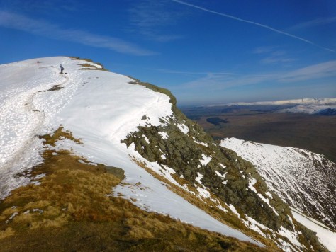
I’ve climbed Halls Fell Ridge before. It has drama aplenty—an exhilarating scramble with steep sides, if not quite as sheer as Sharp Edge, still capable of instilling an air of danger. While holding few genuine difficulties, it does require care. Doddick is a similar slim ridge, but with fewer rock turrets and precipices so it should be a little easier. However, my scrambling abilities are tested before I even start the ascent. Scaley Beck separates Scales Fell and Doddick Fell, and its crossing requires a descent into a steep ravine. The way down is easy enough, but on the other side, a narrow path climbs to a large rock step with a dearth of decent hand and foot holds. After some shenanigans that are most accurately described as scrabbling rather than scrambling, I manage to get one knee over the parapet, and with a little inelegant huffing and shuffling, I haul myself up.

A few minutes later, I’m stuffing outer layers into my rucksack. Out of the wind, the sunshine is warm. It’s a beautiful spring day, quintessential May—except it’s February, and this is alarming. (Still, it would be churlish not to enjoy it).

As I start my winding ascent up the steep foot of Doddick Fell, the green fields of St John’s in the Vale stretch out below, walled into irregular squares like a patchwork chequerboard. Wisps of low cloud soften the charcoal peaks of Clough Head and the Dodds as they rise across the valley, and to the west, the ridges of Coledale and Newlands are dark sails in a sea of fine mist. At 450 million years old, they’re all newcomers compared to Blencathra, which has stood a full fifty million years longer, forged not from cataclysmic volcanic eruptions but formed, over imponderable millennia, from layer upon layer of sedimentary deposits on the sea bed. I can’t tell whether it’s the weight of such eternities, or simply the wind direction, but the noise from the A66 below seems to have disappeared.

Clough Head from Doddick Fell

Across the foot of Hall’s Fell, half a dozen foxhounds are trotting this way. Members of the Blencathra pack, perhaps? Kennelled at Gate Gill, they are a famed company with a lineage stretching back to John Peel, the huntsman immortalised in the seventeenth century song, “D’ye ken John Peel in his coat so gay”. Their master awaits further up the slope here on Doddick. Perhaps I’m just used to seeing farmers dressed in fleeces and coveralls, but in his tweeds, waxed jacked and flat cap, he seems the embodiment of tradition. In spite of myself, I find I’m enjoying the scene. I supported (and still support) the fox hunting ban, and I don’t subscribe to the Countryside Alliance’s view that it is a law passed by Townies who don’t understand country ways. Growing up in the countryside, I encountered as much anti-hunt feeling as pro, even among some farmers whose interests it claimed to serve. Yet, it is possible to acknowledge and appreciate a close working relationship between man and dog, and between both and the landscape, even if you don’t condone the endgame.

Of course, since the ban, the endgame is supposed to have changed. They no longer kill foxes, they pursue fell runners now (which surely even Oscar Wilde would consider fair game). Trail hunting, where a runner lays a trail scented with aniseed or fox urine, was big in Cumbria long before the ban, and the Blencathra Hounds’ website states emphatically that their events keep strictly within the law—any attempt to do otherwise will result in the hounds being returned to their kennels. How rigidly this is enforced, I don’t know, but there’s no bloodshed today, they’re simply exercising the animals. One of the hounds has already reached Doddick, and minutes later, he brushes eagerly past my leg. As I reach the top of the slope, I pass his master, and being British, we comment on the weather, “Aye, wam oop ‘ere”, he grins.

According to Wikipedia, one version of the folk song paints Peel’s coat as grey, not gay. This seems likely, as it was probably made from Herdwick wool. It also reminds me I know the song best from Porridge, where Norman Stanley Fletcher sings an entirely different lyric:

“D’ye see yon screw with his look so vain?
With his brand new key on his brand new chain;
With a face like a ferret and a pea for a brain
And his hand on his whistle in the morning.”

As the initial slope levels off, Doddick’s ridge is revealed. If you ask a child to draw a mountain, they draw a triangle, and this is the shape of things ahead—a perfect chestnut pyramid rising to a pale grey peak. At the top, this fell joins the ridge that curves round from Scales Fell.  The ground between is scooped into a deep and wide gill, its high sides draped in dry heather, like the chocolate fleece of a Herdwick yearling.

Doddick Fell
Doddick Fell
Scaley Beck Gill from Doddick Fell

To my left, is another higher horseshoe. Across Doddick Gill, Hall’s Fell rises to an imperious tower where it becomes Blencathra’s summit, its slopes, a great wall of exposed stone flecked with sparse patches of yellow scrub, topped with rocky turrets and riven by a narrow fissure running all the way down to its foot. It’s a view Wainwright calls “awe-inspiring”. I’m reminded of a friend who used to run the Coniston Launch. I once asked him how he lured punters away from his chief rival, the historic steam yacht, Gondola. “Ah well,” he said, “I tell them the best view of the Gondola is from The Coniston Launch.” The same may be true of Hall’s Fell and Doddick.

Hall's Fell Top
Hall’s Fell Top

A man with a north east accent is similarly wrapt. He tells me he normally climbs Blencathra by Hall’s Fell or Sharp Edge but decided to try Doddick today for a change. He’s not dissappointed. I confess to chickening out of Sharp Edge because of the wind (which sounds lame because here in the lee of the mountain, there isn’t any). He smiles and assures me it’s not as bad as people make out, then as we start up the slope, he admits he’s regretting the six pints he had yesterday afternoon while watching the rugby.

St John's in the Vale from Doddick Fell
St John’s in the Vale from Doddick Fell

Our paths continue to cross as we climb the narrow ridgeline. When I reach Doddick Fell Top, I gaze back over the ascent. He’s two steps behind and looking beyond me.

“Sharp Edge”, he nods.

I turn, and there it is, towering like an impregnable wall over Scales Tarn. Its blue slate sides look well nigh vertical, and a tiny figure strides nervously along its battlements. Just then, we’re buffeted by a huge gust. My companion looks at me with a smile and nods, “Aye, bit windy today”. Then, as one, we glance back to check the solitary figure is still there and not floating in the tarn below.

Sharp Edge
Sharp Edge
Sharp Edge
Sharp Edge

The unseasonal weather has inspired people to pull on their boots, and Blencathra’s summit is crowded. A large group is posing for photo, so I make friends with their dog. We’re on tummy tickling terms by the time his grinning owner reclaims him. I stare down the spine of Hall’s Fell Ridge, falling abruptly away toward Thelkeld below. It promises thrills and adventure, but the day is young, and there are other summits I want to roam.

Hall's Fell Ridge from the summit
Hall’s Fell Ridge from the summit

I set off over the Saddle toward Atkinson Pike. On its eastern flank, lies Foule Crag and Sharp Edge, but to the west, a blue slate scree slope (known imaginatively as Blue Screes) drops to a flat plateau of upland moor—Mungrisdale Common. If Wainwright thought the southern face of Blencathra, Lakeland’s grandest object, he found Mungrisdale Common its least impressive. Indeed, he’s positively rude about it, claiming it “has no more pretension to elegance than a pudding that has been sat on”, and that its “natural attractions are of a type that appeals only to sheep”. But I’ve been reading William Atkins’ book, The Moor, and it’s left me with a deeper appreciation of these boggy, desolate wastelands.

While our moors are as hazardous as our mountains, we conceive of their dangers differently. Literature reinforces this: lofty crags are noble; to scale their heights, heroic; to die trying, worthy. Moors are bleak, lonely places, populated by outcasts; to drown in the bog is the ignominious fate of the wretched.

Atkins’ book teems with tales of men and women who have battled to turn moors into fertile farmland. Yet time and again, the attempt is futile and leads to ruin, even madness. For centuries, our peat bogs were seen as useless waste ground. Today, with the reality of global warming, we’re waking up to their value. We learn in school that plants take in carbon dioxide and release oxygen, but when plants die they release all that stored carbon back into the atmosphere. The sphagnum moss that covers our wetlands is an exception. When it dies it forms the peat that lies beneath, and peat traps all the carbon it collected during its lifetime. Or at least it does if it stays wet. Drain our moors and we release the carbon. Protecting our wetlands is now a task of significant environmental importance.

As a carbon sponge, Mungrisdale Common’s diminutive size means it hardly registers in significance compared with the vast peat bogs of Exmoor, Dartmoor, The Peak District or North Yorkshire, yet as I step off the blue scree and on to the squelchy ground, I look at the green and red sphagnum with a new-found appreciation.

Finding the summit is more problematic. Wainwright declares that “any one of a thousand tufts of tough bent and cotton-grass might lay claim to crowning the highest point”, which means, I suppose, that walkers bagging the Wainwrights need only set foot on the Common to claim it. I decide it deserves more respect, and set off along the broadest of the visible paths heading for what I hope is a patch of imperceptibly higher ground.

Cloud has now swallowed the top Blencathra, but here on the Common, I’m still in sunshine, and the landscape assumes an air of the Wild West. Admittedly, cacti and Comanches are in short supply but there’s something about craggy mountains rising from a broad sweep of straw-hued flatland that evokes John Wayne. I’ve been to Denver a couple of times and always marvel at the plains running flat as a pancake all the way to Kansas, while in the opposite direction the vast wall of the Rocky Mountains rises out of nowhere. Skiddaw is no Pikes Peak, but it’s a giant in Lakeland terms, and it looks “mighty fine” (as they might say over there). The Common compliments Great Calva and Lonscale Fell to similar effect, and I conclude that AW must have been in a unusually unimaginative mood to resist to such charms.

Mungrisdale Common
Mungrisdale Common

I find a cairn which I count as the summit and turn heel for the Glenderamackin Col. At the col, the paths to Bowscale Fell, Blencathra and Bannerdale Crags intersect with a fourth that follows the course of the fledgling river down into the valley.

The Saddle from Bannerdale Crags

Bannerdale Crags looks unexciting from here, a nondescript grassy hillock basking in the shadow of Blencathra’s saddle. That changes entirely when you reach the summit. Here the views are utterly uplifting. To the east, Souther Fell rises over the infant River Glenderamackin, a last noble outpost of the Northern Fells. Beyond is the broad flat sweep of the fertile Eden valley, hemmed by the distant indistinct wall of the Pennines. Immediately to the north, the Tongue rises to the neighbouring peak of Bowscale Fell, and from here the pièce de résistance, the crags themselves, sweep round to meet it, a crescent wall of charcoal cliffs plummeting to apricot slopes beneath. It makes for an inspiring walk, and everyone I pass along its sweep has the same beatific smile.

Souther Fell from Bannerdale Crags


Bannerdale Crags
Bannerdale Crags
Bannerdale Crags
Bannerdale Crags

On the summit of Bowscale Fell, I meet a man who’s sweating and puffing from the ascent. He’s come all the way up from the valley, past Bowscale Tarn, which, according to Wordsworth, is home to a pair of “undying fish”.

“That doesn’t get any easier”, he exclaims.

“Oh, I know”, I reply. “They get higher with age.”

“They certainly do!”, he grins, and staggers off for the sanctuary of the summit shelter.

I wander back down to the Glenderamackin col with the dark Saddle dominating the skyline and follow the stream down into the valley between Bannerdale Crags and Scales Fell. Above me on my right, Sharp Edge looms, looking no less daunting from this angle. Daunting but inspiring, and I find myself whispering, “next time”.

Sharp Edge
Sharp Edge

I leave the path where it rounds the bottom of White Horse Bent, cross the steam by the footbridge, and climb to the col where Scales Fell and Souther Fell meet. From here, the path leads down Mousthwaite Comb and back to Scales, where I left my car.

But Souther Fell is right there, the last bastion of the Northern Fells, and with the weather so amenable, aching legs would seem a small price to pay for making it a big day in the north.

Souther Fell from Bannerdale Crags

In 1745, twenty six men and women swore they’d seen a ghost army marching over Souther Fell. For more on that, my ascent of Hall’s Fell Ridge and the legendary Celtic king who is said to lie beneath Blencathra, click here…

I did eventually get to walk over Sharp Edge. If you’d like to read that account, here’s the link:

http://www.lakelandwalkingtales.co.uk/blencathra-via-sharp-edge/


    Enjoyed this post?

    Like to receive free email alerts when new posts are published?

    Leave your name and email and we'll keep you in the loop. This won't be more than once or twice a month. Alternatively, follow this blog on Facebook by "Liking" our page at https://www.facebook.com/lakelandwalkingtales

    Fire and Water

    Sunset Over Morecambe Bay, In Snow

    Snow covered Coniston Fells beckon, but a computer glitch and an ill-fated Christmas shopping trip, worthy of Father Ted, rob me of a day on their slopes. As a consolation, I climb Hampsfell to watch the sun set over Morecambe Bay. It turns into one of the most magical fell walks I’ve ever experienced.

    December 9th, 2017 and the snow was falling, clothing the peaks in an alluring blanket of white. From my kitchen window, I can see Dow Crag, and in winter, when the trees are stripped of leaves, I can also make out a little of the Old Man of Coniston’s shoulder. By mid-afternoon they were looking positively Alpine, promising all kinds of winter adventure. It was too late to get out today, but Tuesday would be my birthday, and with uncharacteristic foresight, I’d booked the day off work. I checked the Met Office mountain forecast: sunshine and excellent visibility; and with only two days to go, there was just a chance it might be right.

    Sheep at the foot of Hampsfell
    Across the fields

    I was buoyant. Borderline ecstatic. And then it happened. Or at least it didn’t. Sandy switched on her laptop, and nothing responded. Zilch, nada, not a flicker. I’m unusual in being a software developer who hates computers. It’s nothing personal, I just spend so much of my day immersed in them, I try to avoid them in my spare time. I fumbled for an excuse, but it wasn’t forthcoming, and Sandy was panicking, so I felt compelled to help.

    My wife is a freelance journalist and animal photographer. She had two important photoshoots to process in the coming week, and her laptop is a vital tool. Luckily it was still under guarantee, so I got out my phone and looked up the nearest Apple Dealer (I know nothing about hardware).

    “There’s one in Lancaster”, I announced triumphantly. “They can book you in on Tuesday.” 

    “But I’m at the Westmorland Gazette on Tuesday”, she said, far from consoled. “We’re on a deadline. I’m busy all this week”. Then she added, “Don’t you have the day off on Tuesday?”

    My heart sank faster than a Sunderland supporter’s on the first day of the season; or Sue Lawley’s when Wainwright told her he didn’t much like music, at the start of half an hour of air time she was supposed to fill with his choice of Desert Island Discs.

    “There are some nice shops in Lancaster”, Sandy offered brightly. “You could do some Christmas shopping”.

    It was supposed to be a positive suggestion, but the very thought filled me with dread. I have form, you see. Once in Newcastle, with a few hours to kill, I tried a spot of seasonal gift hunting, unsupervised, but it turns out I’m terrible at it. I just wondered around John Lewis like an automaton, unable to find the way out. When I finally did, it led straight into Fenwicks and the nightmare started again. It was like an episode of Father Ted, except there wasn’t a party of priests in the lingerie department that I could follow. (I know this because I looked). When eventually I escaped into fresh air outside the Grainger Market, I seriously considered buying everyone sausages.

    Tuesday arrives, and The Apple Dealer can’t see me until 11:30, so with that and the drive, and the fruitless Christmas shopping, and wandering around Sainsbury’s like an automaton, I don’t get home until 2:30pm. The sky is an unbroken expanse of blue, and the snow-capped Coniston Fells in the distance look magnificent. But they’re half an hour away—by the time I get there, there’ll only be about an hour of daylight left.

    Determined to salvage something from the remains of the day, I wonder about Hampsfell. Hampsfell is a small hill that separates Cartmel and Grange. A tiddler compared to the Coniston Fells, but it punches above its weight with its rare limestone pavements and panoramic views of both the Lakeland fells and Morecambe Bay. Wainwright suggests it might appeal to the semi-retired fellwalker: “It is a hill small and unpretentious yet endowed with an air of freedom and space that will recall happy days on greater heights. It is a place for looking northwest, indulging memories, and dreaming.”

    I’d be on the summit in time to watch the sun set. Sunset over the bay, on a beautiful snowy day, from a summit made for dreaming—that has to be something special.

    I layer up, pull on my boots, grab gloves, hat, headtorch and microspikes and set off. The magic starts almost immediately I step outside the front door. The snow is little more than a dusting of icing sugar on the surrounding fields, but it’s enough to turn the landscape into a Christmas card. A robin hops about the hedgerow and the spire of Field Broughton church rises from a hollow across the meadows to complete the scene.

    I wander up narrow country lanes and on to a bridleway, then a follow a path across a field to a stand of trees above. Sheep graze on scattered patches of exposed grass, their shaggy fleeces like mounds of driven snow. As I climb higher through Hampsfield allotment, the low orange sun blazes like a fireball through a lattice of branch and twig, a giant bonfire amid the deepening white blanket. Galloways roam the open fell side, their coats a swatch of seasonal colour: black, red, yellow, and cream, matching the silhouettes of the naked trees, the autumn bracken and the winter grass. As I approach the summit, something is happening across the valley…

    Galloways on Hampsfell
    Galloways on Hampsfell

    On top of Hampsfell stands the Hospice, a squat stone tower with an open door and an open fireplace; a gift to travellers from the pastor of Cartmel in 1846, and a testament of thanks to beauty here experienced here daily. As Wainwright astutely observes, “Outside, over the doorway, is an inscription that will be Greek to most visitors.”  Translated from the Greek (for Greek it is), the inscription, “rhododactylos eos”, means “the rosy fingered dawn”. Her cousin, the rosy fingered dusk, is at play now.

    Hampsfell Hospice at sunset
    Hampsfell Hospice at sunset

    North-west over Cartmel valley, beyond a brown swathe of winter woodland, the Coniston Fells rise like a frozen tundra, artic blue in the dimming light; but they are transforming before my eyes—awaking, warming as if softly stage-lit in anticipation of an imminent first act—their chiselled contours now reflect a warm pink glow. Behind them, the sky is a wan, ethereal yellow, sparsely streaked with wisps of mauve.

    Old Man of Coniston
    Old Man of Coniston
    Dow Crag & Old Man of Coniston
    Dow Crag & Old Man of Coniston

    As I turn south and climb between snow softened escarpments to the limestone-paved plateau, black skeletal branches of stunted, windblown hawthorn trees bow in unison toward the Hospice, a dark tower before a horizon of deepening orange.

    Hampsfell Hospice at sunset
    Hampsfell Hospice at sunset

    In the short distance to the tower, the colours shift and blend again as the sky overhead darkens. To the east, over the Kent Estuary, Arnside Knott is little more than a soft Prussian blue suggestion below a strip of sky, pink as oyster shells. The reflective snow bestows a strange ambience. The stone fence posts that guard the Hospice are black shadowy sentinels, chained together to repel the shaggy cows that roam like ancient bison.

    Hampsfell Hospice at sunset
    Hampsfell Hospice at sunset

    This is a landscape so familiar yet altogether new. It’s as if I’ve crossed into a parallel universe—somewhere I may have glimpsed on the cover of a 1970’s prog rock album. Folk tales of a faery kingdom that the unwary traveler may pass into and return a haunted, altered man seem suddenly less fantastical.

    Kent Estuary from Hampsfell at sunset
    Kent Estuary from Hampsfell at sunset
    Sunset in snow on Hampsfell
    Sunset in snow on Hampsfell

    Yet, the real drama is happening to the west, where the orange sky intensifies over Bardsea and Barrow. In the sea beyond the dark peninsula, I can just make out tall thin poles, little more than fine grey pencil lines. Using the zoom on my camera, I discern the blades of the wind turbines. This is the offshore wind farm, Britain’s largest. Or at least it is in the parallel world I’m used to. Here, with imagination uninhibited, they are an encroaching army of Martian fighting machines from H G Wells’ War of the Worlds. And they must have opened fire, because all of a sudden the sky and water alike burst into flame.

    Sunset over Morecambe Bay
    Sunset over Morecambe Bay
    Sunset over Morecambe Bay
    Sunset over Morecambe Bay

    In between, a low bank of cloud, the thick smoke of the conflagration, engulfs the peninsula, forming a soft grey barrier between the incandescent sky and its mirror image in the waters. All that’s left of the land beyond the Leven estuary is a thin black strip of shoreline. And before my eyes, a new civilisation emerges. The formless cloud bank resolves into an acropolis of colossal towers, slate grey but licked with yellow, still fresh from the furnace that rages above and below.

    Morecambe Bay sunset
    Morecambe Bay sunset
    Cloud towers of Bardsea
    Cloud towers of Bardsea

    Beyond the Hospice, the snow covered limestone gives way to snow covered scrub. I climb a stile over a dry stone wall and follow a white path lined with a Mexican wave of wind-bowed hawthorns. The south eastern horizon is salmon pink, below quilted cloud the colour of Herdwick shearlings. Copper rivulets snake across dark sands to reach the silver sea beyond.

    Stunted Hawthorn on Hampsfell
    Stunted Hawthorn on Hampsfell
    Salmon Pink sky over the Kent Estuary
    Salmon Pink sky over the Kent Estuary
    Toward Fell End, Hampsfell
    Toward Fell End, Hampsfell
    Toward Fell End, Hampsfell
    Toward Fell End, Hampsfell

    Slowly, the blaze in the west softens to amber afterglow and becomes a slender strip of pale gold beneath a charcoal sky. The cloud city levitates and starts to disperse, and beneath are pin pricks of light, like tiny candles, from the miniature human conurbations of Barrow, Bardsea, Dalton and Ulverston.

    Sunset over the Leven Estuary
    Sunset over the Leven Estuary

    Sunset over Barrow from Hampsfell
    Sunset over Barrow from Hampsfell

    I’ve been reading the memoirs of Flookburgh fisherman, Jack Manning. He knew these patterns of lights like the back of his hand. They were crucial landmarks when out on the sands, on horse or tractor, scooping shrimp or cockle in the dead of night before the tide’s return.

    As I watch the ever changing light show from the subsidiary summit of Fell End, I’m aware of little puffs of steam rising in the dark. I hear a soft footfall and a snort, and I realise I’m not alone. As my eyes adjust, I discern the shapes of sheep grazing quietly on the slope below.

    Sheep at sundown on Hampsfell
    Sheep at sundown on Hampsfell

    The snow is so reflective I leave my head torch in my rucksack. I return to the wall and find the stile has vanished. I’m momentarily perplexed, but when I retrieve the torch and switch it on, the stile materialises right in front of me. It must be darker than I thought.

    Path to Fell End
    Path to Fell End

    And it’s growing darker by the minute; the torch beam accentuates the gloom, but I can no longer see without it. I pass the Hospice and begin the descent back to Hampsfield Allotment.

    Suddenly, I notice something strange in the darkness up ahead. Two little points of light hover above the path. I can’t think what they could be. I’m not given to superstition but with my imagination so stoked it would be easy to start believing in the supernatural. They look like disembodied eyes and they hold their position at around head height. Try as I might to find a terrestrial explanation, none presents itself.

    When I’m no more than a few yards away, I hear the breathing and see the vapour from the invisible nostrils. Slowly her outline materialises. A big Galloway cow, black as the night. She’s staring intently at me, probably wondering what the approaching ball of light might be. When she realises it’s only me, she loses interest, but doesn’t relinquish the path. I give her wide berth, more from respect than fear. Somehow, I sense no tension here. Nothing threatens the peace of this enchanted landscape on this frozen winter evening.

    Just over half an hour later, I turn they key in my front door. I’m back where I started three hours earlier, yet in some intangible sense, I’m still half a world away.


      Enjoyed this post?

      Like to receive free email alerts when new posts are published?

      Leave your name and email and we'll keep you in the loop. This won't be more than once or twice a month. Alternatively, follow this blog on Facebook by "Liking" our page at https://www.facebook.com/lakelandwalkingtales

      Here’s where the story ends

      Paw Prints of the Plague Dogs part II

      News bulletins, artillery fire and the shadow of Sellafield conspire to recreate the atmosphere of Richard Adams’ 1977 bestseller, Plague Dogs, as I continue to follow Rowf and Snitter’s footsteps through the fells. It’s an adventure that takes me off the beaten track in the Duddon Valley, and out to the coast at Drigg, where the story reaches its dramatic finale.

      Seathwaite Tarn, Dow Crag, Caw & Brown Haw

      It’s as if Seathwaite mine has been swallowed by the mountain. The entrance to level no. 1 is buried under a bed of spoil. You could easily miss it, your attention seduced by the precipitous face of Dow Crag reflected in the still waters of Seathwaite Tarn, or the sheer slopes of Brim Fell, Swirl How, and Great Carrs plunging to enclose the valley like a steep sided bowl. Even when looking its way, your gaze would likely lift above to the imposing crags of Grey Friar. 

      Seathwaite Tarn and Levers Hause
      Seathwaite Tarn and Levers Hause
      Grey Friar
      Grey Friar

      But the keen-eyed might notice the remains of two small walls extending from the rubble like the outstretched arms of an avalanche victim. These ruins demarcate the cutting. I climb up and pull away a few loose stones from the top to reveal the hollow behind—the dark of a tunnel entrance. You’d need a JCB to excavate it, but readers of Richard Adams’ The Plague Dogs have a clue to its whereabouts. It sits behind a small plateau of grass, “about the size of a lawn tennis court” on top of a spoil heap; this terrace, at least, is just as Adams described.

      Seathwaite mine level no. 1
      Seathwaite mine level no. 1

      The Plague Dogs is the story of Rowf, a big black mongrel, and Snitter, a small fox terrier, who escape a vivisection lab, fictionally located on the east shore of Coniston Water. The dogs have been subjected to harsh experiments. Before his incarceration, Snitter remembers a happy life, tragically cut-short when his loving master was hit by a lorry. When he and Rowf escape, he imagines the outside world will be a familiar place of houses, gardens, dustbins and lampposts, populated by kindly men and women, who will give them a happy home, like the one he used to know. Their initial encounters are discouraging, however, and the pair flee into the Coniston fells, a frighteningly alien wilderness, where they realise that they must learn to live as wild animals. This old copper-mine tunnel is where Rowf and Snitter first take refuge.

      In a previous post, Whitecoats, I trace the first leg of their journey, using the maps and illustrations contributed to the book by Alfred Wainwright. Today, I pick up their path again.

      Earlier, I met the farmer from Tongue House Farm. He was driving a flock of Herdwicks on to the fellside. I was walking up the narrow lane from Seathwaite village when the sheep charged out of the farm drive. My presence stopped them in their tracks, and in a flash, his sheepdog was beside me, blocking their path and sending them the other way.

      Herdwicks
      Herdwicks

      “That was lucky,” said the farmer, as he arrived at the rear, “there’s not usually someone there to turn them. It’s always the same. If there are two options, they always go the way you don’t want them to.”

      Tongue House Farm
      Tongue House Farm

      As he took off up the lane on his quad bike, I gazed across at the farm house. It features in the story, and the occupant in the book is a real-life former tenant, Dennis Williamson. After years of struggling to make a go of things, Williamson is now just about comfortable, so it’s with some alarm that he finds one of his ewes lying dead on the path at Levers Hause. This was Rowf’s first kill, but it was a rookie error to leave the carcass where Williamson so easily finds it.

      Fortunately for the dogs, they’re not the only occupants of the tunnel. In the dead of night, an elusive presence tries to steal the sheep’s leg that Snitter dragged here. Rowf jumps up aggressively. Snitter is close behind, but when the shadowy creature starts to talk, the dogs are astonished, “for the voice… was speaking, unmistakably, a sort—a very odd sort—of dog language.”

      The animal is the tod, a shrewd, sharp-witted fox. He speaks in a broad rural Northumbrian dialect, and scorns at the dogs’ naivety, “By three morns, the pair on yez’ll bowth be deed”. All the same, he’s impressed with Rowf’s ability to kill ewes, so he offers to school them in survival, if they share their kills with him. On top of Dow Crag, the tod teaches the dogs to kill a sheep by driving it over the precipice (this way, its death looks like an accident). He shows them how to raid chicken runs and snatch ducks from the stream. But when Rowf kills a ewe on Tarn Head Moss, five hundred yards from the tunnel entrance, the tod is incensed: “Forst ye kill on th’ fell—reet o’ th’ shepherd’s trod, clartin’ th’ place up wi’ blood like a knacker’s midden. An’ noo ye kill ootside wor aan nyeuk! Thon farmer’s nyen se blind! He’ll be on it, sharp as a linty. Ye’re fee th’ Dark, nee doot, hinny. Yer arse’ll be inside out b’ th’ morn.” (Translation: now you’ve killed outside our own lair. That farmer’s not blind. You’re as good as dead.)

      Great Gully, Dow Crag

      Despondent, Rowf considers giving himself up, but the tod knows better, “Yer nay a derg noo, yer a sheep-killer. The’ll blaa yer arse oot, hinny. Howway let’s be off, or ye’ll bowth be deed an’ dyeun inside haaf an hoor, ne bother.”

      The tod leads the way up above the reservoir, below the summits of Dow Crag and Buck Pike, and down to the Walna Scar quarries. From there, they climb over Caw to a cave on the slopes of Brown Haw.

      Two paths lead that way from here: one follows Far Gill up to Goat Hawse, over the summit of Dow Crag and along the ridge line. The other tracks the southern shore of Seathwaite Tarn. The animals’ route is somewhere in between. Looking up, I see only crags, sheer and unassailable, but the OS map shows that the incline eases above them, and a strip of gentler terrain runs below the spine. There are no paths here, but if I follow the course of Near Gill to its source above crags, then walk on a bearing to Bleaberry Gill, the stream will take me down to a wall that leads to the quarries. At one point, Adams says the dogs are nine hundred feet above the reservoir road; I count the contours; this looks about right.

      Seathwaite Tarn from copper mine
      Tarn Head Moss

      The path across the squelching bog of Tarn Head Moss is no more than a line of flattened reeds. I leap the beck and cross the sketchy trod that leads up to Goat Hawse. I ford Far Gill and start my pathless ascent beside Near Gill. It climbs steeply beside the crags. Where they finish, the slope relents and the stream curves round into the wetter ground above. Green sphagnum moss carpets the spongy peat. I check the compass and track below the ridge.

      The moorland is moist, but firmer than the valley bottom. Hassocks of straw-coloured grass anchor the hummocks of soft moss. Elsewhere are red stalks of bog cotton, its white candyfloss flowers long gone. Harter Fell rises across the valley—a mossy pyramid, upper reaches defended by charcoal crags. Its lower slopes are swathed in russet, striped with yellow and coppiced with evergreen. Underfoot, clumps of rare red sphagnum now compliment the green.

      Harter Fell from Dow Crag Fell
      Harter Fell from Dow Crag Fell

      I cross a brow and start to descend. The distant wall is in sight below, with the Walna Scar quarries beyond. Ahead, there is a break in the long rampart of hillside where the slopes of White Pike drop steeply away. The high ground rises again to the summits of Pikes and Caw, but through the gap, I can see silver inlets of the Irish Sea. The sky above is a rolling ocean of cloud – raging white breakers and darker swells.

      Bleaberry Beck
      Bleaberry Beck
      Clouds over Dunnerdale
      Clouds over Dunnerdale

      I stray northward to overlook the reservoir road. From here, the tod spots Dennis Williamson, walking purposefully toward the mine, shotgun in hand.

      When I reach the Walna Scar quarries, I have a dearth of daylight hours left to me so turn down to Seathwaite. I return at first light, when the grey fluffy clouds above the fell have orange underbellies. Across the valley, the Scafells are flood lit red. Harter Fell wears incandescent robes of gold and green, and in silhouette against the flaming sky, the slate ruins of quarry buildings are dark satanic mills.

      Caw from the Walna Scar road
      Caw from the Walna Scar road
      Scafells at first light
      Scafells at first light
      Walna Scar quarry buildings
      Walna Scar quarry buildings
      Walna Scar quarry buildings
      Walna Scar quarry buildings

      A Herdwick ewe eyes me with suspicion. She carries a red smit mark on her back. The tod understands that smit marks are shepherds’ marks. He points out to Rowf and Snitter how the colours used here are different from those on the ewes near the copper mine. If Rowf were to kill here, it wouldn’t further antagonise Williamson.

      Under White Pike, the path traverses the soggy sump of Yaud Mire, and I leave it to scramble between the crags to the summit of Pikes. Caw lies across another boggy depression; a trig point stands on a slender rocky plinth to crown its highest point.

      Caw summit
      Caw summit
      Grey Friar from Pikes
      Grey Friar from Pikes

      The descent to Long Mire Beck is steep and slippery. Ahead, on the slopes of Brown Haw, I spy the cave that becomes the dogs’ new hideout. Once I reach it, however, I realise it’s an illusion; what I took for an entrance is just shadow cast by the low winter sunlight. I hunt further along, but the cave eludes me. I meet a walker, striding with the easy confidence of someone who knows his way. I ask if he knows of a cave, but the only one he can think of is a quarry tunnel on the north-western face of Caw. He’s curious at my question, so I ask if he’s read The Plague Dogs.

      “Rowf and Snitter?” he grins, his face suddenly animated with memories of childhood.

      I show him a photo of the Wainwright map that gives the cave’s location. We agree it’s pretty much where we’re standing.

      I never do find it, but I climb to the tops of Brown Haw and Fox Haw (which seems appropriate), then return to Seathwaite on a track that the dogs will come to know.

      Brow Haw from Caw
      Brow Haw from Caw

      ~

      When further sheep are found dead, and word gets out that two dogs have escaped from the Lawson Park laboratory, Dennis Williamson kicks up a fuss. Mr Ephraim, a gentleman’s outfitter, organises a hunt, hoping the publicity might boost trade. Unfortunately, he doesn’t know one end of a shotgun from the other, and his inexperience results in a tragic, fatal accident. Snitter is seen running from the scene. When the story reaches the offices of the London Orator, a notorious tabloid, it’s the opportunity they’ve been looking for. Their owner is keen to discredit the government. There has been some controversy about the public funding for Lawson Park. If the Orator can discredit the lab, they can embarrass the Secretary of State. An unscrupulous but brilliant young reporter, named Digby Driver, is dispatched to Cumbria with a remit to dig dirt on the lab and spin the story of the killer dogs into a national scandal.

      As the heat rises in Dunnerdale, the tod leads the dogs over Crinkle Crags and Bowfell, through Langstrath to Wythburn and up on to the Helvellyn range. From here, Sticks Pass offers access to the farmsteads of Glenridding.

      Rowf and Snitter are caught raiding a chicken coup. The farmer has a shotgun, but inexplicably, he backs away in fear and encourages the dogs to escape. Unbeknown to them, Digby Driver has published some shocking revelations. As part of top-secret research for the MOD, Lawson Park has been cultivating a strain of bubonic plague. There is no way the dogs could have been infected, but fact never got in the way of a good headline and now, in the public mind, Rowf and Snitter have become the Plague Dogs—public enemy number one; pawns in a political game.

      Driver has the Secretary of State in check, and just as intended, awkward questions are asked in the House. To save his skin, the minister employs an age-old politician’s trick—misdirection. If he can be seen to act decisively, perhaps the concerns about funding and who knew what about the plague research will all go away.

      Two battalions of paratroopers are dispatched to Cumbria, and the minister means to preside, in person, over the Plague Dogs execution.

      Back in Dunnerdale, Snitter watches helplessly as the tod is torn apart by hounds. With the army closing in, he and Rowf make one last brilliant move. By night, they flee over Harter Fell and down into Boot, where they hide out in a wooden crate; exhausted, they fall asleep. When they awake, they’re moving. Unknowingly, they’ve stowed aboard L’ile Ratty, the steam train that runs between Eskdale and Ravenglass. Rowf and Snitter are heading for the coast.

      Harter Fell from Park Head road
      Harter Fell from Park Head road

      If he knew, Dennis Williamson would undoubtedly be delighted. He bitterly regrets raising the alarm. The dogs were no trouble at all compared with the human circus that has followed. He knows the plague hysteria is nonsense and wholeheartedly hopes the dogs escape. It’s a faint hope, however. They’re spotted in Ravenglass, and the army units are mobilised.

      Ravenglass and Drigg

      It’s out of season when I cross the footbridge in Ravenglass station. L’ile Ratty isn’t running, but an open carriage, like Rowf and Snitter’s, is parked in the siding below.

      All the way here, the car radio was reporting on the furore unfolding in Westminster. Theresa May has just presented her Brexit plan to parliament, and her ministers are queuing up to resign. Pundits are particularly bemused by the departure of Dominic Raab, who helped negotiate it. As the papers spin the story to favour whichever faction best suits their agenda, it dawns on me that this has all the hallmarks of Adams’ novel. Plague Dogs is how he saw the British political landscape in 1977; forty-one years later, it seems little has changed. Vox pops with members of the public reveal attitudes not dissimilar to Dennis Williamson’s—whatever it was we wanted, it wasn’t this.

      The rivers Irt, Mite and Esk commingle in the Ravenglass estuary. The tide is out, leaving moored yachts beached and the river channels exposed. This is just how it is when Rowf and Snitter arrive. They escape the village by running across the mudflats and swimming the River Irt to reach the Drigg sand dunes. My route there is a little more circuitous. I follow a country lane from Low Saltcoats to Hall Carlton and cross by the packhorse bridge at Holme Bridge. From here, a path runs over fields to the sleepy coastal village of Drigg. Beside the quaint rural station, a road leads down to the beach.

      Ravenglass estuary
      Ravenglass estuary
      Ravenglass estuary
      Ravenglass estuary

      Before I reach the shore, I pass something altogether more menacing. High security fences topped with rolls of barbed wire protect the Drigg low level nuclear storage facility. A sign warns that armed guards patrol at unpredictable times. Another says that the site is protected under section 12b of the Serious Organised Crime and Police Act 2005. This is all very evocative of eighties’ TV drama, Edge of Darkness, about a low-level nuclear storage facility that’s illegally processing weapons-grade plutonium. Swap a nuclear facility for a laboratory researching germ warfare, and we have a scenario not a million miles away from The Plague Dogs.

      Behind the Drigg facility is Sellafield, the nuclear reprocessing plant that really was designed to extract plutonium from spent fuel rods. It’s visible through a gap in the sand dunes. Someone has positioned a bench such that you can sit and look at it. This may seem bizarre, but it’s perhaps indicative of the regard in which Sellafield is held around here. It’s rejuvenated the area, providing large numbers of people with well-paid jobs. To others, though, it is a Sword of Damocles, hanging over our heads by the finest of threads.

      Drigg Low Level Nuclear Waste Repository

      By the time I reach the beach, the nuclear facilities are hidden by the dunes. What’s here instead is a breathtakingly beautiful stretch of coastline, a nature reserve and a site of special scientific interest, a haven for natterjack toads, stonechats, sandpipers, skylarks and all manner of marine life. The tide has turned but a wide stretch of sand is still exposed, riven with delicate channels and intricate rock pools, studded with shells—cockle, razor clam—and patterned with the honeycomb stencilling of lug worm colonies.

      Drigg Beach
      Drigg Beach
      Drigg Beach
      Drigg Beach
      Drigg Beach
      Drigg Beach

      I walk the one and half miles to Drigg Point, lost in the lazy, wild wonder of the beach. But as I reach the headland, my reverie is broken by an explosion. Across the estuary, a red flag is flying. The artillery are conducting large calibre gun testing on the Eskmeals range. I look back to Ravenglass and the route Rowf and Snitter took to get here. For them too, armed troops are closing in.

      Drigg Beach
      Drigg Beach

      The sun slips behind a bank of cloud, and the sky darkens. Out to sea, slender shafts of golden light pierce the gloom and spotlight the white crests of waves. The horizon is a band of ethereal yellow. All of a sudden, the scene assumes a drama befitting of the book’s dark heart.

      Drigg Beach
      Drigg Beach

      And that dark heart is human. It asks us hard questions about ourselves and our relationship with the natural world. Near the end, Snitter has a revelatory vision:

      “The world, he now perceived, was in fact a great, flat wheel with a myriad spokes of water, trees and grass, forever turning and turning beneath the sun and moon. At each spoke was an animal—all the animals and birds he had ever known—horses, dogs, chaffinches, mice, hedgehogs, rabbits, cows, sheep, rooks and many more which he did not recognize—a huge striped cat and a monstrous fish spurting water in a fountain to the sky. At the centre, on the axle itself, stood a man, who ceaselessly lashed and lashed the creatures with a whip to make them drive the wheel round. Some shrieked aloud as they bled and struggled, others silently toppled and were trodden down beneath their companions’ stumbling feet. And yet, as he himself could see, the man had misconceived his task, for in fact the wheel turned of itself…”

      But the novel is also an allegory about how we treat each other. The Brexit vote was howl of protest at a disengaged elite, governing in their own interest—out of touch with the hardships faced by ordinary people. Average incomes have flat-lined over the past ten years, and we’ve been hurt by savage cut-backs, implemented in the name austerity, to bear the cost of bailing out our banking system. In the run up to the referendum, the finger was pointed at immigration, but the causes of our current situation are multi-faceted and far-reaching. They stretch back to the 1980’s and the deregulation of the money markets that sent the value of the pound skyrocketing and did for British manufacturing. They encompass the takeover of the City of London by large American investment banks, and forty years of ripping up employment law in the hope that leaving everything to the free market will bring prosperity.

      And it has. To some. We’re now the sixth richest nation in the world, but 20% of all that wealth lies in the hands of just 680,000 people, while almost twice than number are obliged to use food banks. Can we really lay the blame for all of that at the feet of the ordinary individuals who are now being spat at in the street and told to “go home”? They’ve become the scapegoats, the Plague Dogs, callously used by media moguls to sway public opinion in favour of political initiatives that advance in their own agendas. With the current farce unfolding in Westminster, the guns sounding across the estuary, and the shadow of Sellafield on the sands, the atmosphere of Adams’ novel is perfectly evoked.

      I sit down on a dune and gaze out at the encroaching waves. In my mind’s eye, a small fox terrier and a black mongrel stand before them. To stay on land means certain death, but to swim out to sea seems like suicide. An optimist to the last, Snitter wonders whether they could reach the Isle of Man. Rowf doesn’t like the sound of that, but Snitter has heard tell of another place, a better island, the Isle of Dog. It has to be out there somewhere. Perhaps, just perhaps, they could reach it. Despite his suffering, Snitter has always been sustained by hope, and it sustains him now as he leads his friend out into the icy waters.

      The Irish Sea
      The Irish Sea

      The book and the film conclude differently. I’ll divulge neither denouement, but they both play out in my head as I sit on the beach and gaze over the Irish Sea—for according to Wainwright’s final map, right here is where the story ends.

      Drigg Beach
      Drigg Beach


        Enjoyed this post?

        Like to receive free email alerts when new posts are published?

        Leave your name and email and we'll keep you in the loop. This won't be more than once or twice a month. Alternatively, follow this blog on Facebook by "Liking" our page at https://www.facebook.com/lakelandwalkingtales

        Whitecoats: On the Path of the Plague Dogs, Part I

        Raven Tor, Levers Hause and Seathwaite Tarn.

        In Richard Adams’ 1977 bestseller, Plague Dogs, Rowf and Snitter are two dogs subjected to cruel experiments in a vivisection lab. When an unsecured catch and a loose bit of wire afford a means of escape, they find themselves in the Coniston Fells. Adams describes the landscape in vivid detail, and original editions of the book are illustrated in characteristic part sketch/part map style by one of Lakeland’s greatest apostles. Inspired by the story, I put on my boots and set off on the path of the Plague Dogs.

        I’ve never read Watership Down. I was seven when it was published, but it didn’t cross my radar until the film of 1978. By then I was thirteen, and I’d just discovered Black Sabbath. I had long hair and a full-length leather coat from Oxfam, which I thought made me look like Geezer Butler. My mum had a different take. It was only after a year of people telling me the same thing that I came to accept that she might actually be right: the padded shoulders, pinched waist, faux fur collar and the particular arrangement of buttons meant it was unquestionably a woman’s coat, and if it made me look like anyone, it was Bet Lynch.

        My teenage tunnel vision dismissed Watership Down as a cartoon about rabbits, soundtracked by Art Garfunkel and clearly aimed at girls; not the sort of thing a pimply, pubescent Prince Of Darkness should be watching, even if he was unknowingly experimenting with cross-dressing.

        Eventually, I ditched the coat but never recovered sufficient good sense to read the book or watch the film. Now, at the tender age of fifty-two, I’m desperate to put that right because I’ve been utterly bowled over by The Plague Dogs.

        Plague Dogs by Richard Adams
        Plague Dogs by Richard Adams

        The Plague Dogs was Adams’ third novel. It tells the story of Rowf and Snitter, a big black mongrel and a little fox terrier who escape from a vivisection laboratory and make for the hills. At first, they incur the wrath of local farmers whose sheep they kill in an attempt to stave off starvation, but when an unscrupulous tabloid journalist, with a remit to embarrass the Secretary of State, gets involved, the story snowballs into a national furore, inflamed by an unsubstantiated allegation that the dogs could be carrying the bubonic plague. Questions are asked in the House, and the army is despatched to assassinate our innocent canine heroes.

        It’s a rollicking adventure, an emotional rollercoaster and a biting political satire, but it’s also a passionate anti-vivisection statement. The cruelty and utter pointlessness of the procedures beggars belief, yet in his preface, Adams confirms that “every ‘experiment’ described is one which has actually been carried out on animals somewhere”.

        It’s not a wholly one-sided picture, however. No sooner do we sense that Stephen Powell, a young scientist at the lab, is becoming increasingly uncomfortable with his work than we learn his young daughter is suffering from a terminal illness. It’s Powell’s desperate hope that animal research will yield a breakthrough before it’s too late to save her.

        And yet the experiments are as barbaric as they are futile: Rowf has been subjected to a succession of near drownings, repeatedly submerged in a tank of water and only revived once he goes limp and sinks to the bottom. He has never known men other than the “whitecoats”. Despite his traumatic experiences at their latex-sheathed, disinfected hands, he still wants to be a good dog and please his masters; but he can’t face another day in the immersion tank. Snitter’s story is even sadder as he remembers a blissfully happy home life before his beloved master was knocked down by a lorry—an accident for which Snitter blames himself. The details are incoherent because the whitecoats have cut open Snitter’s head and rewired his brain to confuse the subjective and the objective. As a result, he suffers disorienting confusion and bouts of vivid hallucination. In his lucid moments, however, he’s smart. Smart enough to notice an unsecured catch and a loose bit of wire. Smart enough to figure out how he and Rowf might escape. When they do, it’s into a landscape very familiar to lovers of Lakeland.

        The real Lawson Park was a remote fell farm on the eastern bank of Coniston Water; now it’s an artists’ retreat, run by Grisedale Arts. Never in reality has it been any sort of research lab, but it’s the fictional location of Animal Research (Scientific and Experimental), A.R.S.E. for short—the setting for Rowf and Snitter’s inhumane treatment in the interests of science. When they make a break for hills, they find themselves in the Coniston Fells, which Adams renders in rich detail.

        Coniston Fells
        Coniston Fells

        My friend, Gillian, grew up in Coniston and suggested I should read the book for this very reason. “You could walk the routes and write about it in your blog”, she said. It sounded a fine idea, so I searched for The Plague Dogs on Amazon. I was one click away from buying the current paperback, when a customer review caught my eye.

        “Before buying a copy of The Plague Dogs I took out a request from the library and ended up with an older edition. It was a wonderful hardback – the illustrations of the Lake District by the late Alfred Wainwright complimented Adams’ rich, vivid prose perfectly. Sadly though, the illustrations have been removed from this recent (2015) re-issue.”

        The original hardback was illustrated by Wainwright? This was the edition I had to have. Google found me a second-hand copy for £1 + £3.99 p&p. It arrived two days later, and it looked wonderful. As well as hatched pencil drawings of the fells, there were eight characteristic route maps, rendered in the same part sketch, part map style, familiar to readers of AW’s Pictorial Guides. Indeed, for Wainwright fans, the book is a welcome supplement.

        Page 46
        Page 46

        Wainwright was also an ardent anti-vivisectionist, and Adams says in the preface, “I seriously doubt whether an author can ever have received more generous help and co-operation from an illustrator”.

        It’s in the early hours of a crisp autumn morning that Rowf and Snitter make good their escape. As the sun rises, they find themselves on the wild expanse of Monk Coniston Moor. Snitter is appalled. What have the men done? “They’ve taken everything away, Rowf—the roads, cars, pavements, dustbins, gutters—the lot. How can they have done it?”

        The pair head down hill, cross the road and trot along the shore of Coniston Water. Here, Snitter is entranced by how still everything looks beneath the surface. Would his racing mind be as calm if he was in there? Rowf is terrified of the water, however, and remonstrates with his friend not to go in. “You can’t imagine what it’s like”.

        Monk Coniston Jetty
        Monk Coniston Jetty

        Coniston Water
        Coniston Water

        Buoyed up by the sight of houses in the distance, the fugitives head along the road to Coniston village, but Snitter is overcome by one of his turns and has to lie down. A car stops, and two men get out to help, but when they try to pick Snitter up, Rowf assumes they are trying to recapture him and return him to the lab. He springs forward in attack and frees his friend, and the pair run for the village.

        Coniston village
        Coniston village

        Rowf is understandably wary of men, but Snitter knows they’re not all like the whitecoats. On the streets of Coniston, he remembers shops. In his former life, these were places where people made a fuss of you and gave you treats. They try their luck in a butchers’ shop. The friendly but fastidious proprietor comes over. He means no harm and crouches to greet them, but his hands smell of disinfectant, he’s carrying a knife, and a pair of scissors protrude from the pocket of his WHITE COAT.

        The two dogs flee up the walled lane beyond The Black Bull and out into the Coppermines Valley. On page 46, Wainwright documents their route, and on a bright November morning, this is where I pick up the trail.

        Track to Coppermines Valley
        Track to Coppermines Valley

        Church Beck
        Church Beck

        Track to Coppermines Valley
        Track to Coppermines Valley

        Above Miners’ Bridge, the Old Man, Brim Fell, Swirl How and Wetherlam are ablaze, lit orange and blue in the first light of morning, just as Adams describes. I follow the track beside Low Water Beck to the Youth Hostel. Here I pause to check the map and imagine the scene. As I do, I hear a faint patter and something soft brushes my leg. It’s a black dog. After a startled double take, I make friends with an excitable border collie, who can’t hang about because he’s just spotted a big stick. His loving owners are laughing as they catch us up, “that’ll be the first of many, today”, the woman grins. Proper masters, as Snitter might say.

        Miners' Bridge
        Miners’ Bridge

        Church Beck waterfall
        Church Beck waterfall

        Border Collie, Coniston Youth Hostel
        Rowf?

        The main track swings right along the lower slopes of the Black Sails ridge, but I turn left towards the quarry, its marbled face, a dark daubed cubist canvas below the tufts of russet scrub. The road is blocked by a gate. It’s padlocked, but perhaps only to vehicles. Beyond, the word “Footpath” has been scrawled on a slate. I climb the bars and start up the faint grassy trod to which it points. Above the spoil heaps, I join the path from Crowberry Haws. Two slate cairns stand guard, and a Herdwick grazes unperturbed.

        Quarry, Coppermines Valley
        Quarry, Coppermines Valley

        Quarry, Coppermines Valley
        Quarry, Coppermines Valley

        Wetherlam from Boulder Valley
        Wetherlam from Boulder Valley

        I cross the footbridge into Boulder Valley and pause by the Pudding Stone. The path continues to Levers Water, but immediately above, Brim Fell towers, craggy and intimidating. Anxious to escape the reach of man, it’s up these steep slopes that Rowf and Snitter start. I feel duty-bound to follow, although perhaps not strictly in their paw steps. They have me at a disadvantage: for one, they’re dogs—replete with four legs and a low centre of gravity; and two, they’re fictional, so they have the intrinsic power to do whatever Adams’ imagination invents. He has them climbing on the line of Low Water Beck, clambering up its boulders, skirting its shallow falls and splashing through its brown pools. His co-conspirator, Wainwright, plots the path. But from where I’m standing, the beck is an angry cascade, crashing down a severe ravine. I see no way up for a meagre middle-aged mortal.

        Low Water Beck ravine
        Low Water Beck ravine

        In his Pictorial Guide, Wainwright advocates a mildly more man-friendly route, which climbs a grassy rake on the opposite side of the crag. I detect what might be a path leading to the crag’s foot. It proves something of a mirage, and I’m quickly off piste, but I track around the bottom of the rocks toward the strip of mossy green. A brief scramble provides a short-cut, and soon I’m clambering up steep and slippery grass. It’s hard going, requiring hands and feet, and I can see why AW advises against it for descent. But it’s not far from the beck, so I feel I’m being as true as I can to the plot, and besides, I’ve always wanted to try this ascent, AW promises it furnishes a fuller understanding of the fell’s true structure.

        Simon's Nick, Coppermines Valley
        Simon’s Nick, Coppermines Valley

        I reach an old mine level, where the curled ends of rail tracks protrude like vestigial limbs. Here a path of sorts emerges; it’s a steep rocky staircase, skirting a river of loose stone, but the going is firmer than before, if no kinder on the calves. Eventually, the gradient relents, and I’m confronted with a vision that fills Rowf with dread—the limpid corrie tarn of Low Water, a pool of primeval tranquility, a dark oasis of serenity below the plunging slopes of the Old Man, but to poor traumatised Rowf, a huge, menacing immersion tank.  He races away up the slope to the summit of Raven Tor. I sip coffee, catch my breath, and just as Snitter does, I follow.

        Looking back down from Brill Fell ascent
        Looking back down from Brill Fell ascent

        Raven Tor
        Raven Tor

        Beyond the summit, the ground drops abruptly to Levers Water. Strangely, despite its larger size, the tarn holds no fresh dread for Rowf. It’s just as well because Snitter spots a line of sheep by the western shore. They’re being pursued by two border collies and a man. The man is whistling and calling to the dogs, encouraging them to chase the sheep, and the dogs are listening and responding. Man and dog, working as a team. Here at last is a proper master. All he and Rowf have to do now is bound down the fell side and join in. If they chase the sheep too, perhaps the man will give them a home, and food, and a happy life away from the whitecoats.

        Levers Water from Raven Tor
        Levers Water from Raven Tor

        My descent is more circumspect. The slopes below the col look precipitous. In his Pictorial Guide, AW shows a route beside Cove Beck. I follow a narrow trod over the spine of Gill Cove Crag, in the shadow of Brim Fell’s summit, and as the contours diverge, I descend through increasingly soggy ground. Eventually, I hear the sound of running water, and the beck appears, a narrow scar trickling elusively through scrubby moorland.

        Beyond, a cairn marks the path up to Levers Hause. Between here and the waterline, Rowf and Snitter make their ill-fated attempt to gain a master by chasing his sheep. Luckily, his sheep dogs reach them first and vent their anger in broad Cumbrian:

        “Art out of the minds, chasing yows oop an’ down fell, snappin’ an’ bitin’?”, fumes one. “Wheer’s thy farm at? Wheer’s thy master?”.

        When Snitter explains, “we haven’t a master. We want to meet yours”, the answer is unequivocal: “He’ll fill thee wi’ lead”.

        I turn and follow the forlorn fugitives’ escape route up steep rocky steps to Levers Hause. Here, the dogs ruefully acknowledge they’ll find no welcome in the world of men. They must become wild animals. Still stoked from the chase, Rowf attacks a mountain ewe. He makes the kill, but takes a fair battering in the process. With his hunger satiated, exhaustion takes hold, and the big black mongrel lies down in the bog myrtle to nurse his injuries. Meanwhile, Snitter despairs at the bleakness of their prospects. As his synapses start to misfire, he scampers down the steep slopes to the Duddon Valley in a firestorm of neurotic confusion.

        Levers Water from Levers Hause path
        Levers Water from Levers Hause path

        A right of way runs from Levers Hause to the far shore of Seathwaite Tarn. Or at least it does on the map. There’s little sign of a path on the ground, and the gradient is frightening. I’d have to be as mad as Snitter to attempt it, and yet somehow, I do. I climb down a little way to test the going, stepping sideways from grassy tuft to stony shelf. Emboldened, I soldier on. Part way down, I imagine a path, but it’s just a loose spray of scree, too shallow to offer much support. Zigzagging avoids the severest sections, and earlier than I’d reckoned, I’m approaching the tumbling waters of Tarn Beck.  Here, the ground grows marshy; the valley bottom is a quagmire, red with reed beds as it reaches out to Seathwaite reservoir. I keep to a contour to stay out of the worst. The sun is streaming over Dow Crag, bleaching the fell sides and blinding me with its glare.

        Seathwaite Tarn from Levers Hause
        Seathwaite Tarn from Levers Hause

        Tarn Beck

        Duddon Valley and Seathwaite Tarn
        Duddon Valley and Seathwaite Tarn

        Here, Snitter does what I decline to do. Lured by the fevered machinations of his scrambled mind, he breaches the beck and splashes through the boggy ground on the other side. The kindly man in the brown tweed coat that he imagined was there is an illusion, but as the fit passes and the world comes back into focus, he spots something else. Something welcome. Something real. Just shy of the reservoir he finds a small spoil heap:

        “On top was a levelled space of turf and small stones, perhaps half the size of a lawn tennis court. It was completely empty, but on the further side, where Great Blake Rigg, the south face of Grey Friar, rises like a wall was a symmetrical, dark opening, lined and arched with stones”.

        I’m looking at it now (through binoculars).  It’s an old level of Seathwaite copper mine, and in the book, it becomes a temporary home for Rowf and Snitter. Here, they meet the tod, a wily fox, well-versed in the ways of the wild.  His savvy, calculating instinct for self-preservation contrasts markedly with the dogs’ innocent loyalty. He’s appalled by their naivety and sees them as a liability, likely to draw the attention of farmers and their shotguns. Yet, in Rowf he also sees a valuable asset: there’s not many a wild Lakeland beast can bring down a full-grown ewe.  The dogs might have their uses after all, and an uneasy alliance is formed.

        Rowf and Snitter's new home

        Rowf and Snitter’s new home

        Short winter daylight hours dictate that here, for now, I must take my leave. But as I make the day’s last ascent out of lonely Dunnerdale and up to Goat Hawse, the peace is broken by an alarming bark, fuelled with feral bloodlust. A chilling chorus of murderous howls swells into an amplified echo, and on the lower slopes of Grey Friar, I make out a swarm of white dots moving fast across the fell.  With binoculars comes comprehension: fuzzy points resolve into a pack of foxhounds. They’re coursing an aniseed trail. It’s profoundly unsettling because it’s a scene straight from the book. In all my years on the fells, I’ve never witnessed this, yet later in the story, Snitter sees the self-same thing.  Only this time, it’s not aniseed they’re hunting… it’s the tod.

        To be continued…

        Read the second part of my journey along the path of the Plague Dogs here:

        Here’s where the story ends


          Enjoyed this post?

          Like to receive free email alerts when new posts are published?

          Leave your name and email and we'll keep you in the loop. This won't be more than once or twice a month. Alternatively, follow this blog on Facebook by "Liking" our page at https://www.facebook.com/lakelandwalkingtales

          This Land is Your Land

          A Dragon’s Back and a Right to Roam

          An away trip to the Peak District, to walk the iconic profile of Chrome Hill, provokes a rumination on the right to roam, the mass trespass of 1932, and the fact I owe my life to the Ramblers’ Association. En route, we get spooked by the Quiet Woman in Earl Sterndale and have a chance encounter with the Sundance Kid.

          Revolution

          In 1917, the tyranny of the Russian Tsar had fallen to the hammer and sickle in a matter of months, but in Britain, a slow-burn revolution smouldered. Every inch as rooted in class conflict and social injustice, its aims were humbler: they demanded not the overthrow of the ruling elite, but the right to roam; the right for open access to land that had once been common, but for the last four centuries had been systematically enclosed—taken from the many and given to the few. Enclosure had swept away the old feudal system, where land was worked collectively for subsistence, and created a nation of landless poor and landed gentry. The land itself had become a commodity to be owned and worked for profit.  Protest songs didn’t start with Bob Dylan—in England, a sixteenth century bard penned this:

          Hang the man and flog the woman
          That steals the goose from off the common
          But leave the greater felon loose
          That steals the common from the goose.

          With industrialisation, the massed ranks of rural poor flocked to the cities to work the mills, mines and factories of the industrial north. New hardships, diseases and health problems awaited. By the beginning of the twentieth century the physical and spiritual benefits of the great outdoors were widely appreciated. In increasing numbers, men and women would escape the urban sprawl at weekends to seek out clean air and green space, and increasingly, they found their way blocked. England’s green and pleasant land had become a playground for the rich elite, populated with game and shooting lodges. Commoners were not welcome.

          “We ramblers, after a hard week’s work, in smokey towns and cities, go out rambling for relaxation and fresh air. And we find the finest rambling country is closed to us … Our request, or demand, for access to all peaks and uncultivated moorland is nothing unreasonable”. So spoke Benny Rothman in his own defence at Derby Assizes. Twenty-one-year-old Benny was on trial for helping organise the mass trespass of 1932: on April 24th, over four hundred men and women left Sheffield and Manchester to walk together in protest over Kinder Scout, in what is now the Peak District.  The land was owned by the Duke of Devonshire, and he deployed a band of keepers armed with clubs to forcibly deter the trespassers. A full-scale fight broke out, and the keepers were easily overwhelmed. But the judge’s sympathies lay with the landowner, and Benny was jailed, along with four of his friends.

          The sentences caused outrage and fuelled popular support for the right to roam.  In 1935, the Ramblers’ Association was formed to advocate for walkers’ rights at a national level and to promote the benefits of rambling to ordinary people. Their efforts eventually bore fruit: in 1951, the Peak District became England’s first National Park. It was known as the “lungs of England”.  By the end of the decade, the Lake District, Snowdonia, Dartmoor, Pembrokeshire Coast, North York Moors, Yorkshire Dales, Exmoor, Northumberland and Brecon Beacons had all followed suit. It took until the year 2000, however, for the Countryside and Rights of Way Act to secure open access for the public to all uncultivated upland and downland.

          Away Trip

          This is on my mind for two reasons: I’m driving south on the M6 for a weekend’s walking in the Peak District with my friend Tim; and the other night, my mum mentioned that my granny and grandad met on a Ramblers’ Association walk in the Lake District.  I never knew.  A love of treading the Lakeland fells had evidently skipped a generation in our family, but now my mountain passion seems less like an aberration and more a resumption of an older family tradition.  My granny came from the mining village of Astley, near Manchester. She was warm, outgoing, outspoken and would laugh easily and heartily. My grandad was a southerner—serious, reserved, shy and meticulous. They complimented each other perfectly, but they most likely would never have met had it not been for the Ramblers’ Association—so without the Ramblers’ Association, I wouldn’t be here.

          Beyond the urban sprawl of Greater Manchester, I crawl through Glossop.  Under an overcast sky in dimming light, it appears drab and austere. I give way to a pedestrian at a pelican crossing.  He’s in his early twenties, shoulders hunched, belly spilling over his belt, lank, greasy hair, plastered thinly across a forehead that wears the perennial look of defeat; his T-shirt bears the moniker, “the Sundance Kid”.

          As Glossop’s answer to Robert Redford recedes into the distance, something magic happens: the buildings stop, the road leads uphill past a sign for “Snake Pass”, and without warning, I’m launched out into the sublime sweep of lonely, windblown, wilderness that is the Dark Peak. I’ve made this journey many times, and the soaring rush of exhilaration that kicks in at this point never ever diminishes. I think of Benny Rothman and how hard he fought for the right to roam here.

          From here on, the drive is pure joy. The stresses of the week evaporate as this dramatic landscape casts its spell. Eventually, beyond the mesmeric glint of the Ladybower reservoir, the bright lights of Sheffield appear.  Soon after, I’m knocking on Tim’s door, which he opens in a pinny with a bottle of wine in hand.  This is good news—he’s a great cook.

          Over dinner and several glasses of wine, Tim rattles off suggestions for tomorrow’s adventures.  Kinder Scout is mooted, but intriguingly, he also ponders going further afield, to the White Peak, to walk the Dragon’s Back.

          I keep a careful eye on the time. Tim’s kitchen is built on a wrinkle in the space-time continuum.  I’ve been caught out many times before: if you let the hands of his clock reach half past midnight, you’ll look up a couple of minutes later to find it’s half past three (which doesn’t make for the best start to a day out rambling).  I sneak off to bed at twenty-nine minutes past twelve.

          The Dragon’s Back

          Over breakfast, the Dragon’s back idea wins out, and we set off for the Dove valley near Buxton.  The Peak District is a single National Park but encapsulates two very different terrains.  The northern part, which juts up against Sheffield, is the Dark Peak, a dramatic expanse of untamed moorland: savage, intimidating, unkempt, and in early spring, still looking every bit the desolate winter scrub. Huge swathes of earthen colour—bands of brown, yellow and rust—are punctuated by long escarpments and outcrops of gritstone, weathered into smooth, rounded, surreal-looking formations like piles of pebbles on a giant’s beach.

          The Cakes of Bread, Dark Peak
          The Cakes of Bread, Dark Peak

          As we cross into Derbyshire and Staffordshire, the aspect changes character completely.  We find ourselves amid gentle rolling hills and green pastoral valleys. This is the White Peak—the Dark Peak’s prettier, softer sibling. Yet as we crest the top of a hill and head towards Longnor, Tim directs my gaze right, to an astounding sight, quite out of keeping with its surroundings.  It’s as if two colossal dinosaurs, hibernating beneath the valley floor, have awoken and thrust their arched backs up through the earth, their spines ridged with jagged plates; and due to some inscrutable ancient mystery, they have become fossilised in the process, their skins turned to grass, and their armour plate into limestone pinnacles.

          Chrome Hill and Parkhouse Hill
          Chrome Hill and Parkhouse Hill

          These are the iconic profiles of Chrome Hill and Parkhouse Hill, known collectively as the Dragon’s Back. In 1997, writer Jeff Kent brought Chrome Hill to wider attention, when he discovered it boasts a double sunset. If viewed from Parkhouse Hill or Glutton Bridge, on or around the summer solstice, the sun appears to set, then re-emerges and sets again. In an ideal world, we’d have read Jeff’s book, and we’d be visiting on the summer solstice to observe the spectacle. As it is, we’re two months early and I won’t find out about the phenomenon until I browse Wikipedia, a few weeks later. Nevertheless, I can’t wait to get my boots on when we park in Longnor.

          The long easy walk-in takes us to Hollinsclough, past its chapel, and down through fields to a stream, where the dampness of the grass sends me tumbling for an early mud bath. The going gets firmer as we gain height. After a prolonged winter, the recent rain and warm April sunshine lend a spring vitality to a day that might almost be summer, were the trees not still bereft of leaves.

          Hollinsclough chapel
          Hollinsclough chapel

          Dovedale
          Dove valley

          Chrome Hill
          Chrome Hill

          We reach a brow and Chrome Hill rises before us in all its quirky, spiky magnificence.  We sip coffee at its foot then start to scramble up between its craggy pinnacles, minding our step—wet limestone is nearly as slippery as wet grass.

          Chrome Hill
          Chrome Hill

          Chrome Hill
          Chrome Hill

          At 1394 feet, Chrome Hill stops some way short of a mountain, but on character alone, it outranks grassy domes more than twice its height. The Hill has a mountain personality and a mountain’s power. The narrowness of its ridge emphasises the steepness of its sides, and the rolling pastures of the White Peak stretch out forever below.

          On the summit, two men and a dog are gazing out over the expansive views.  We’re all beaming with the sheer exuberance of the experience (especially the dog).

          View from Chrome Hill
          View from Chrome Hill

          View from Chrome Hill
          View from Chrome Hill

          View from Chrome Hill
          View from Chrome Hill

          The descent is severe, and we worry how we’ll stay upright, but these south-east slopes have been sun-kissed for several hours, so the grass is dry and the going proves easy enough.  At the bottom, the slimmer, sharper, lower ridge of Parkhouse Hill rises enticingly, but there’s no right of way shown on the map, and we’re unsure of its status.  Later, we’ll learn that it has been classified as open access under the 2000 act, but it was long disputed, and I realise the right to roam is not just the story of Benny’s battle from a previous century, but still very much a living, burning, contentious issue.

          Parkhouse Hill from Chrome Hill
          Parkhouse Hill from Chrome Hill

          Our route meanders beside meadows alive with bouncing lambs and grazing ewes. You can almost feel the surge of new life bursting from the ground, and to walk amongst it is an emotional tonic just as much as a physical one.  We find a bench-like boulder beside a dusty country lane, under trees chirruping with bird song, and tuck into our grub. Tim’s local baker has supplied a pork pie of Brobdingnagian proportions, forged with a finesse that would embarrass Heston Blumenthal. Tim has also packed veritable house bricks of Yorkshire brack, smothered with butter to a depth that James Martin would readily endorse.  After gorging greedily on this fine fare, Tim checks the map and starts to chuckle.

          “Guess where we are”, he says.

          “I’ve no idea”, I reply.

          “We’re in Gluttondale”, he smirks.

          The Quiet Woman

          After a couple of miles, the lane leads into a village. Tim, who’s a couple of yards ahead, stops abruptly and looks up with purpose. I follow his lead and my eyes meet a pub sign that’s immediately disquieting.  It takes a minute to work out why.  The artwork is slightly garish, bearing the hallmark of Hammer House of Horror film poster from the 1970’s.  The pub is called the Quiet Woman and bears the inscription, “soft words turneth away wrath”, beneath which is a crude painting of a woman, presumably the landlady; only, something is missing… Oh yes, it’s her head.

          The Quiet Woman, Earl Sterndale
          The Quiet Woman, Earl Sterndale

          The sign seems to be implying that a woman should be seen and not heard, and the most effective means of achieving this is decapitation.  The exterior of the building is dark-beamed, and the windows latticed. Their glass reflects the afternoon sun, rendering them utterly impenetrable.  It makes the Slaughtered Lamb in American Werewolf look positively hospitable. Suddenly, eerily, it feels as if we’ve arrived in Royston Vasey. In actual fact, it’s Earl Sterndale, which, as names go, is even more intimidating.

          The story behind the pub sign is every bit as dark as you would imagine. The original landlady was an incessant nag and gossip, known locally as Chattering Charteris.  Her relentless mithering proved too much for her beleaguered husband, who cut off her head. Far from provoking outrage, his action won the wholehearted approval of the villagers who clubbed together to pay for her headstone.

          Someone is waving at us from one of the tables on the beer terrace out front.  It’s one of the guys from the summit of Chrome Hill.  They seem to be enjoying themselves, but perhaps they haven’t seen the sign, and now they’re walking unknowingly into a terrible trap, like Edward Woodward in the Wicker Man.  Or perhaps they’re locals, and they’re in on it.  We smile wanly and hurry on in the faint hope that our gender might spare us from the village executioner.

          A little further on, a woman leans over the fence of a paddock where two children and a dog are trying to corral some young lambs.  She greets us warmly and we chat. It’s a delightful scene that quickly dispels the darker suspicions of moments ago. Well almost. What if it’s a buttering up exercise, a diversionary tactic to lull us into a false sense of security, while the men of the village sharpen the axes or weave the last canes into the body of the wicker man?

          We take our leave and walk on briskly past the arresting pyramidal hill of High Wheeldon, through a quagmire of mud and cow muck, and back to the safer environs of Longnor, where we risk a relaxing pint in the Market Square.  Or at least, I do. Tim has a Coke, because he wants to stop on the way home to introduce me to a new micro pub in Sheffield, called the Itchy Pig (or the Itchy Anus as it’s affectionately known).

          Just as we’re leaving, the two guys and the dog from the Quiet Woman arrive in the square. We wave less cautiously this time, relieved to see they’re still sporting their heads.

          Outside the Itchy Anus, Tim insists we sit in the car for thirteen minutes, until the clock strikes six and the parking becomes free.  Well when in Yorkshire…

          Inside, I order two pints of a particularly fine IPA and some chilli pork scratchings.

          “They’re hot”, says the barman, looking me right in the eye. “Very hot.”

          I nod and carry them back to our table where we dig in.  I look around and clock the barman staring over, waiting to gauge our reaction.  I smile and hope he can’t see the plumes of steam that are now pouring out of my ears, and the fact that my face has turned crimson.  I have it on the good authority of a contact in the chilli trade that Heston Blumenthal, with the help of an MRI scanner and a hapless sous chef, has proved that hot chilli activates the areas of the brain associated with happiness.

          So, perhaps it’s the pork scratchings, or perhaps it’s escaping execution in Earl Sterndale, or perhaps it’s the grateful recognition that men like Benny Rothman have won us the freedom to roam edifying natural phenomena like Chrome Hill, but after an inspiring journey through Staffordshire, Derbyshire and Yorkshire, I’m believe I’m grinning like a Cheshire cat.

          Chrome Hill
          Chrome Hill

          Sources/Further Reading

          The Ramblers’ Association. (No date). General History. Available at http://www.ramblers.org.uk/about-us/our-history.aspx (Accessed Aug 2018)

          Eric Allison (2012). The Kinder Scout Trespass: 80 years on. The Guardian, 17 April. Available at


            Enjoyed this post?

            Like to receive free email alerts when new posts are published?

            Leave your name and email and we'll keep you in the loop. This won't be more than once or twice a month. Alternatively, follow this blog on Facebook by "Liking" our page at https://www.facebook.com/lakelandwalkingtales

            Reconstruction of a Fable

            The Fairfield Horseshoe and the Skulls of Calgarth

            In which I walk the fine mountain ridges of Fairfield Horseshoe, tell the spooky story of the Calgarth skulls, bag a free beer in Rydal, become a social pariah in Ambleside, and  learn a life lesson from Laurence Fishburne.

            The Skulls of Calgarth

            As I drive through Troutbeck Bridge, I pass a sign for Calgarth Park, offering two-bedroom supported retirement apartments. Viewings are available.  I’m sure both my age and my bank balance disqualify me (although one is depressingly nearer than the other). All the same, I’d be tempted to have a peek—the building has an interesting history, and a sinister backstory.

            The house is an elegant lakeside villa—all Georgian pillars and neatly manicured lawns—overlooking Windermere. It was built by Bishop Richard Watson in 1790. In its early years, it played host to such eminent neighbours as Wordsworth, Southey and Coleridge. During the First World War, it was transformed into a hospital, and later became a children’s orthopaedic unit, specialising in TB and polio.

            When Bishop Watson bought the estate, it already had a hall, but he didn’t much like the look of it. Perhaps it was the cold and austere demeanour. Perhaps he was a forerunner of Kevin McCloud’s Grand Designers and fancied something modern, handsome and hospitable. Or perhaps, he knew about the skulls.

            In the sixteenth century, a humble cottage stood on the spot. It was the home of Kraster and Dorothy Cook. They weren’t rich, but they worked hard, and they ran a productive and profitable farm.

            Living and working in such an idyllic location should have brought endless happiness, but there was a fly in the ointment. Their land was coveted by a rich and influential justice of the peace, named Myles Philipson. He was a greedy man. His estate was substantial, but it wasn’t enough. The Cooks had something he wanted, and it consumed him. He swore he’d acquire the land by any means.

            It proved harder than he thought. Money didn’t work: the Cooks were simple, honest folk, who appreciated what they had and wanted nothing more. Philipson tried bullying, but the Cooks were strong and stood firm.

            In the end, their steadfastness paid off. Philipson backed down. Indeed, it seemed he’d had a complete change of heart and deeply regretted his behaviour. To make amends, he invited them round for dinner on Christmas Eve.

            Dorothy and Kraster must have felt their troubles were over, but they were rudely awakened the next morning by soldiers demanding to search their cottage—Philipson had accused them of stealing a silver goblet. It was soon found in Dorothy’s bag—precisely where the maleficent magistrate had snuck it.

            The Cooks were arrested and imprisoned, awaiting trial. They must have been scared stiff, but they had faith in their own innocence and in the British justice system. Imagine their dismay when they entered the courtroom to find Philipson presiding.

            Philipson declared them guilty and sentenced them to death, decreeing that all their land be signed over to him as compensation. He quickly set about demolishing their cottage and building a hall on the same spot.

            From the gallows, Dorothy uttered a terrible curse: for as long as the Philipson family remained in residence, Kraster and she would haunt them night and day, and their business affairs would never prosper.

            One year later, the hall was complete and the Philipsons moved in, but any celebrations were derailed when they found two skulls on the bottom stair. They had their servants throw them out and retired to bed, but they were kept awake by a terrible screaming and wailing. When they rose in the morning, the skulls were back.

            Over the coming months, Myles had the skulls crushed, burned, buried and thrown in the lake. Whatever he tried failed: the infernal screams persisted, and every morning the skulls returned.

            Living under such a curse quickly put paid to visitors; the family became reclusive and their business affairs suffered. In the end, Myles had to sell everything but the hall to cover his debts. He bequeathed the hall to his son, but the curse remained. Only once the Philipson family quit the hall for good, did Kraster and Dorothy lie quietly in their graves.

            The Fairfield Horseshoe

            Each lake has its own character: Wastwater is feral and fiercely beautiful; Coniston, tranquil; Ullswater dark and mysterious (especially when cloud envelopes the fell tops); but Windermere has grandeur. It’s a grandeur that has little to do with her flotillas of yachts or the moneyed mansions that line her eastern shore. A daunting profile dominates her northern skyline, her head cradled by a ring of high fells, a vision of strength and drama. Dressed in snow and reflected in the long mirror of the lake, the Fairfield Horseshoe is a sight to stir the blood and quicken the heart; in the spring sunshine of this May Day Bank Holiday, its slopes are gold and green, softer than in winter but every bit as inspiring.

            I park in Ambleside and head up Nook Lane to Low Sweden Bridge, following a wide track that then winds its way up the lower reaches of Low Pike. A dry-stone wall meanders in from the left. The track swings right in search of a gentler ascent, but a narrow path handrails the wall, heading up over steeper ground to Low Brock Crag. This way signals greater adventure.

            A short and easy scramble brings me to the crest of Low Brock Crag. Windermere commands the backward view, nestling languidly in a glacial groove—long cool and periwinkle blue.

            Low Brock Crag
            Low Brock Crag

            The summit of Low Pike is further half-scramble, rising in a rocky outcrop like a bouldered earthwork, wedded to the wall, which curves away below like a castle’s outer curtain. Dropping down from this little tower, I land in its shallow moat. The ground between here and High Pike is a soggy morass. In the weeks to come, an extended heatwave will dry Lakelands’ most pervasive bogs, but for now, I have to pick my path with care.

            By the time I reach the top of High Pike, the wall is broken down in places, blending ever more closely with the crag, as if born of the mountain, it aspires to revert.

            Windermere from High Pike
            Windermere from High Pike

            High Pike
            High Pike

            After a long grassy rise, I reach Dove Crag’s summit cairn, and gaze out again over Windermere—its further reaches now visible beyond the headland, stretching out toward a white sheen of Irish Sea, blurring the distinction between earth and sky.  In February, I stood on this very spot, when snow, cloud and soft light conspired to blend lake, sky and fellside in an ambient glow of pink and white. Now the soft blue haze of imminent summer inflects the lowland, and the slopes are olive green with young bracken; shafts of sun stage shadow plays across the crags ahead.

            Windermere from Dove Crag in snow
            Windermere from Dove Crag in snow

            This ancient landscape of immutable rock is in a constant state of flux. Pinnacles, crevices, crags and gullies are thrown into sharp relief, then retreat into shadow; hues of red and yellow, mauve and purple streak fleetingly across the slopes, then blur and are swallowed again by dark recesses of green. It’s an animated impressionist painting of ever-shifting ephemera.

            Mountains are restless chameleons. As John Berger expresses it so beautifully, in Hold Everything Dear: “There are moments of looking at a familiar mountain which are unrepeatable. A question of a particular light, an exact temperature, the wind, the season. You could live seven lives and never see the mountain quite like that again; its face is as specific as a momentary glance across the table at breakfast. A mountain stays in the same place, and can almost be considered immortal, but to those who are familiar with the mountain, it never repeats itself. It has another timescale.”

            From Hart Crag and over Link Hawse to Fairfield’s rocky shoulder, the terrain grows more rugged and dramatic; precipitous crags plunge to Dovedale and Deepdale and I’m compelled to make small diversions to gain a better view.

            On reaching one of Fairfield’s summit shelters, I sip coffee from a thermos and stare over at St Sunday Crag, rising like a dinosaur across Deepdale Hause. In sun, its livery is flecked with gold and purple, and streaked with stripes of exposed stone like strips of armour plate. Captured on canvas and hung in a gallery, critics would think it a stylised exaggeration, and yet the reality is more intense.

            I head south, following the cairns down the western spine of the Horseshoe to the summit of Great Rigg.

            Great Rigg summit
            Great Rigg summit

            Between 1955 and 1966, Alfred Wainwright published his Pictorial Guides to the Lake District, a series of seven books that document 214 peaks with hand-drawn maps, pen and ink drawings, practical direction and poetic description. The series has been continuously in print, and to climb all 214 has become known as “bagging the Wainwrights”.

            The desire to bag Wainwrights now infects my judgement. Where once, I’d have been content to continue directly down the main ridge, the prospect of ticking off Stone Arthur waylays me, and I make a detour to the right, descending rapidly over ground that will all have to be regained.

            It’s not obvious where the summit is as it isn’t really summit at all, just an outcrop on the ridge—and there are several. I meet a couple who are asking themselves the same question. We alight hopefully on the first contender (hopefully, because it’s not too far down the slope—but somehow, we know this would be too easy). They check their GPS and confirm the elevation is too high. We carry on together down the incline.

             Approaching Stone Arthur
            Approaching Stone Arthur

             Approaching Stone Arthur
            Approaching Stone Arthur

            They tell me they’re attempting all the Wainwrights in a year, so the Horseshoe, with the addition of Stone Arthur, is like concocting several syllables from all the high-ranking Scrabble letters and landing on a triple word score—a grand total of nine ticked off for about eleven miles of effort.

            When we reach the proper “summit”, the vivid blue of Grasmere beguiles below.

            It’s a slog back up the slope to Great Rigg and a great relief to finally descend toward Heron Pike, with the forget-me-not fingers of Windermere and Coniston Water outstretched below. The final stretch down the pitched zigzags of Nab Scar overlooks Rydal Water, glittering like a teardrop in the green of the valley.

            Rydal Water from Nab Scar
            Rydal Water from Nab Scar

            When I reach the bottom, fatigue kicks in, and I sit on a wall above Rydal Mount, looking at a sign for the Coffin route to Grasmere (and trying not to read it as a suggestion).

            I walk on through the grounds of Rydal Hall where a girl is emptying paper plates into a bin. She looks up and smiles and says, “Do help yourself to a beer if you’d like one.”

            I pinch myself to make sure I’m not dreaming, but she’s still here, and she’s gesturing behind me, where three kegs are perched on the wall.

            “We’ve had a wedding reception but there’s some beer left over, so we thought we’d offer it to walkers. We’ve no glasses so you’ll have to make do with a jam jar—they’ve all been washed”, she explains brightly.

            I thank her and pour myself a sparkling jam jar of Jennings Cocker Hoop. We chit chat for a minute or two, then she heads back inside. As she reaches the door, she turns and says, “take it with you if you want—we don’t need the jam jar back.”

            A good cool hoppy ale never tastes better than after a long walk. Sipping this unexpected trophy, I head on down the wide Rydal-to-Ambleside path, where I pass several groups of strollers: not sweaty fell walkers now, but smartly dressed, respectable types, out for a gentle Bank Holiday peramble.

            And they’re giving me decidedly funny looks. The third time it happens, I check my flies. Then it dawns on me—I’m carrying a jam jar that’s now about a quarter full of frothy amber liquid. They think it’s a urine sample. And I’m swigging it.

            Cocker Hoop
            Cocker Hoop

            To Have or to Be

            As I drive back past Calgarth Park, I notice that the next lane is called Old Hall Road. Out of curiosity, I turn down it. After a few hundred yards the road narrows and a large sign warns, “Private Road—Keep out”.  I wonder about continuing and try to think of a cover story, but better judgement prevails.

            Later, I’ll wonder if it actually said “no access”, but “keep out” is the message I get, loud and clear, and right now this feels hostile. Perhaps it’s the apparent terseness of the wording or just the abrupt end to the freedom of the fells; or perhaps it’s the recollection of a newspaper article about the scandal of London councils selling social housing to luxury property developers. Perhaps it’s because She Drew the Gun’s Poem has been playing on the car stereo, “How long before they put up a wall and call it a private city?” But all of a sudden, the story of the Calgarth skulls seems very real.

            This is when I realise it’s not a ghost story at all but a morality tale about a man haunted to the edge of insanity by his conscience.

            In the 1970’s Erich Fromm wrote a book called To Have or to Be. He suggested people are governed by a having orientation—the desire to possess things—or a being orientation—the desire to experience things. Those of us who tread the fells have our walking boots firmly in the being camp.  (That said, perhaps our desire to bag summits and tick off Wainwrights betrays an underlying having orientation. Here, I should probably confess I got all this from an episode of CSI. I did buy the book, but I haven’t read it yet, so for now, this is coming via Laurence Fishburne.)

            While the being orientation is the likelier path to happiness, Fromm predicts that our western obsession with consumerism means the having orientation will predominate. Forty years on, we’ve already travelled a long way down that road.

            Beware the skulls.

            Find a route map and directions for this walk at https://www.walklakes.co.uk/walk_42.html


              Enjoyed this post?

              Like to receive free email alerts when new posts are published?

              Leave your name and email and we'll keep you in the loop. This won't be more than once or twice a month. Alternatively, follow this blog on Facebook by "Liking" our page at https://www.facebook.com/lakelandwalkingtales

              Away from the Numbers

              Grey Friar, Great Carrs, & Dow Crag from Seathwaite

              It was to be my 100th Wainwright. Not quite halfway, but a minor milestone nevertheless. The day begins inauspiciously with a series of farcical calamities worthy of Basil Fawlty, but en route to the Seathwaite reservoir, the disarming beauty of the Duddon valley works its magic. After a splendid ridge walk, I celebrate in the rural charm of the Newfield Inn—the scene of a violent riot, 114 years ago, which ended in the fatal shooting of a navvy. Hard to believe these days, but I’m on my best behaviour just in case.

              It’s not as if I was expecting fanfares, a red carpet and a Champagne breakfast on the terrace. That would be ridiculous—we haven’t got a terrace. But on a morning that marked a minor milestone in my fell walking career, I did, at least, want things to go smoothly.

              It wasn’t to be. I awoke to find the cat had thrown up over the sofa cushions. He’d even managed to hit a car rug perched over the arm. The scatter pattern suggested he’d been projectile vomiting while spinning like a whirling dervish. Was he violently ill or possessed by a legion of demons? It didn’t look like it.

              I’ve seen enough episodes of CSI to know how to work a crime scene, and here I found grass and a sizeable clump of matted fur (quite possibly not his own). Cat lovers will know that grass is an emetic which cats imbibe deliberately to shift fur balls. The ensuing upchuck is relatively controlled, so this extravagant distribution was clearly a matter of choice. The proud perpetrator was now standing by his bowl, demanding his breakfast.

              After half an hour of intensive fabric cleaning, I stuffed Wainwright’s Pictorial Guide to the Southern Fells into my rucksack and set off for Seathwaite.

              I’ve lived in Cumbria for twenty years and I’d never been into the heart of the Duddon valley. I’ve gazed down on it many times from the tops of the Coniston fells, ever struck by its lonely beauty. In autumn, the Seathwaite reservoir had shone like a sapphire on a baize of burnished gold. Today, the fields and trees are a swatch of fresh June green, licked into life by the early morning sun. I could easily lose myself in carefree reverie, but I need to concentrate because I’m not entirely sure where I’m going.

              The Duddon valley
              The Duddon valley

              Herdwick lamb in the Duddon valley
              Herdwick lamb in the Duddon valley

              After Seathwaite, the map shows a fork in the road, with the right-hand prong giving way to the old quarry track that leads up to the Walna Scar Pass and on to Coniston. The reservoir track starts from the same point. Sure enough, the road forks where expected and there is even a sign saying “Coniston, unfit for cars”. But as the winding single-track road narrows to no more than my car width, I start to question why it is I think there is off-road parking at the end of it.

              The road ends abruptly in a gate—with no parking space anywhere to be seen. A farmer on a quad bike is approaching from the other side. He clearly wants to come this way. I recall a distinct lack of passing places and the road is too narrow for a three-point turn. There’s nothing for it but to reverse back to the farm I passed quarter of a mile back.

              Parking sensors are wonderful things, but they don’t know the difference between dry stone walls and cow parsley. Given the abundance of foliage overhanging the verges, my dashboard is lit up like a Christmas tree and my ears are ringing from the continuous high-pitched beep. I reach the farm, but I’m too close to the opposite wall to back in. I effect a painfully faffing five-point manoeuvre, while trying to avoid the eye of the farmer, who I sense is laughing heartily. Eventually, I manage to let him past. He gives a cheery wave and speeds off down the lane, no doubt dying to get home and tell his wife all about his encounter with Mr Bean.

              I follow him back to the Seathwaite road. On the edge of the village, there are four parking spaces. One is still free. Perhaps my luck is changing.

              It’s a rash hope. I open the hatchback to find the top isn’t properly on one of my water bottles and it’s emptied itself entirely into one of my boots—the one I’d put my socks in. I pour 500ml of water out of the boot and wring out the socks as best I can, then I squelch one and a half miles back up the road to the gate. I go through and just on the other side, I find the parking spaces.

              Then, I step in a cowpat.

              As I tramp up the reservoir track, I feel every bit like Basil Fawlty scouting around for a branch with which to give the day a damn good thrashing… But subconsciously, I start to change gear. There’s a song going around in my head. It’s The Waterboys’ Don’t Bang the Drum—it was playing on the radio on the way here:

              “Here we are in a fabulous place
              What are you gonna dream here?
              We are standing in this fabulous place
              What are you gonna play here?
              I know you love the high life, you love to leap around
              You love to beat your chest and make your sound
              But not here man – this is sacred ground
              With a Power flowing through
              And if know you you’ll bang the drum
              Like monkeys do”

              The song warns of being so pumped up with our own self-importance, or perhaps with peeved indignance at the banana skins life leaves littered in our path, that we can stand in the most astounding of places and fail to realise.

              I stop to apply sun cream, and I wake up to where I am. The epiphany strikes like an earthquake. A minute ago, the Duddon valley was a place of cowpats, frustratingly hidden car parks and wet feet. Now it’s a place of astonishing power and disarming beauty.

              Across the valley, a conspiracy of sun and shadow renders the Scafells as an Art Deco railway poster—broad, flat, angular and stylised.

              The Scafells from the Duddon valley
              The Scafells from the Duddon valley

              To the east, the sheer green slopes of Brim Fell, Dow Crag and Walna Scar form a colossal rampart to rend the valleys of the Duddon and Coniston. And straight ahead, rising over rippling foot hills, is the grassy dome of Grey Friar—the only Coniston fell I’ve yet to set foot on. Except, it isn’t really a Coniston fell at all. As Wainwright points put, Grey Friar belongs entirely to the Duddon.

              Grey Friar from the Seathwaite reservoir track
              Grey Friar from the Seathwaite reservoir track

              Ticking off all the Wainwrights hadn’t been a goal. I was more interested in getting to know my favourites well—experiencing all their ascents and ridge walks. However, some gentle hectoring from my neighbours, Paul and Jeanette, convinced me that tackling the full 214 is a great incentive to explore new ground. They’re right, and since committing to the challenge, my knowledge of the peaks has grown exponentially.

              I’ve climbed all the other mountains in this range at least twice and some (like The Old Man) as many as eight times. But Grey Friar, I’ve been saving. It will be my 100th Wainwright.

              The OS map shows no path, but Wainwright sketches two that wend in parallel up the south western ridge. The first, a grass rake, is clearly visible from the track, but the intervening ground is marshy. AW suggests continuing to the reservoir and starting from just beyond the outtake channel. His second path is more direct and starts from the same place.

              After a mile or so, I crest the hill and the long buttressed curve of the dam wall appears at the foot of dark shadowy slopes. As I reach the walkway that traverses the top, the sun slips behind a cloud, so now over the parapet, the dark waters stretch out—a long black placid pool, cool and inscrutable.

              Seathwaite reservoir
              Seathwaite reservoir

              The reservoir’s tranquillity belies the violence in its construction. The ancient tarn was dammed in 1904, to extend its capacity as a water supply. The summer was a scorcher; the work was hard, and tempers were frayed. In such a small and remote community as Seathwaite, tensions were strained between locals and the labourers drafted in to sweat and toil. It would only take a spark to ignite the tinder.

              In the event, alcohol proved the accelerant. According to Dick Sullivan’s book, Navvyman (Coracle Press, 1983), Owen Cavanagh had been drinking heavily since 9am. By noon, the landlord of the Newfield Hotel (now the Newfield Inn) judged he’d had enough. As Cavanagh’s rowdiness threatened to get out of hand, the landlord demanded he and his mates leave the premises. The men refused. They smashed up the pub and stole bottles of whisky, then they spilled into the street where they pelted the church and the vicarage with rocks. The publican, a barman and an engineer confronted the rioters with firearms. Shots were fired wounding three—fatally in Cavanagh’s case. The gunmen were arrested but later acquitted on the grounds their actions were legally justified in protecting property.

              A primeval peace pervades now. The ghosts of rampaging navvies don’t haunt the fruits of their labours. I follow the walkway along the top of the dam and cross the footbridge over the main and auxiliary tarn outlets.

              Seathwaite reservoir from the walkway
              Seathwaite reservoir from the walkway

              Between the crags of Great and Little Blake Rigg, Grey Friar’s slopes are more forgiving—grassy terraces peppered with rocky outcrops. Where Wainwright shows the start of his direct route, the tiniest of cairns hints at a faint path. I augment the cairn with a couple more stones—now you’ll have to blink a fraction longer to miss it.

              Great Blake Rigg
              Great Blake Rigg

              In places, you have to rely on instinct and common sense to determine the line of the path. In others, it’s more pronounced, but nowhere is there any difficulty. A moderate pull up grassy slopes attains the ridge, and I make for the summit. Two cairns, a little way apart, stake equally convincing claims. Wainwright judges the north-eastern contender to be the true summit but concedes the south-western has the better views. He’s right, I pull myself up a rocky step and hunker down beside it to gaze across at Harter Fell and the Scafells.

              Seathwaite reservoir from Grey Friar
              Seathwaite reservoir from Grey Friar

              Summit cairns, Grey Friar
              Summit cairns, Grey Friar

              South-western summit Cairn, Grey Friar
              South-western summit Cairn, Grey Friar

              A blue haze, like a sea mist, transforms the peaks into a mythical realm, where black spires, full of menace and foreboding, rise above dappled flanks, pretty and beguiling, and dark hollows harbour mysteries, old as the hills themselves.

              One hundred Wainwrights under my belt is still seven short of halfway. Even so, it’s a ton, a nicely rounded sum, and it feels like an accomplishment. Grey Friars was a fine choice. It’s an underrated mountain, but away from the numbers, these are the kind that can reward the most. It’ll be a different story across on Scafell Pike. At this time of year, walkers will be arriving by the coach load. The Let’s Walk the Lakes Facebook group are tackling that today. Three weeks ago, I climbed Skiddaw with them. It was my first outing with the group, and a nicer bunch of like-minded people you couldn’t hope to meet. I wave in their direction and look forward to our next hike together. Then I set off for Great Carrs.

              Just shy of the summit is a memorial cairn to the wreck of a Halifax bomber that crashed here in 1944. I’ve written about that at length in Ghost of Canadian Airmen, so I won’t repeat myself here, but the cairn with its cross and its plaque, together with the little wooden crosses people plant among the stones to commemorate their own departed loved ones, never fail to move me.

              Memorial Cairn on Great Carrs
              Memorial Cairn on Great Carrs

              I don’t know how this looked in Wainwright’s day. It’s been rebuilt, so perhaps its appearance is more poignant now, but I find AW’s casual dismissal of it as a pile of aeroplane wreckage a tad perplexing. I’ve always suspected his curmudgeonly character was a slightly tongue-in-cheek persona: the bonhomie and humour in his writing suggests someone a little better disposed to people than is commonly supposed. But this throwaway line in the Grey Friar chapter does seem to reveal a more damaged individual, either lacking empathy, or perhaps, so used to burying his feelings he found them awkward to deal with when they surfaced.

              I cross the shoulder of Swirl How and head over Brim Fell. The sky darkens, and it spots with rain. The hills are now a solemn grey, the Seathwaite reservoir a sombre sheen. But the dark clouds above Dow Crag are clearing and the ones overhead are insubstantial. They lack the ammunition for a proper downpour. Halfway to Dow Crag’s summit, the sun breaks through in triumph. By the time I reach the top, it’s glorious.

              Brim Fell from Swirl How
              Brim Fell from Swirl How

              I read a number of walking blogs, and I enjoy Tessa Park’s, not only because it’s called Mountains and Malbec (which scores double points in my book), but because she champions the use of the ARSE CRAMPON. The concept is not entirely new, Wainwright remarks on the usefulness of the posterior, particularly in descent, but Tessa coined the phrase and she deserves a shout-out as I make liberal use of this piece of equipment in scrambling off the summit rocks.

              Dow Crag’s buttresses and gullies are some of most dramatic features to be found anywhere in Lakeland. Its top is peppered with plunging vistas of heart-stopping beauty. Intrepid climbers perch on precarious outcrops high above the blue glimmer of Goat Water.

              Dow Crag
              Dow Crag

              Climbers on Dow Crag
              Climbers on Dow Crag

              Goat Water from Dow Crag
              Goat Water from Dow Crag

              Dow Crag
              Dow Crag

              On the way down over Buck Pike and Brown Pike, Coniston Water is a hazy aquamarine wash to the east, while to the west, a band of barley forms a golden heart in the Lincoln green of the Duddon Valley. On reaching the Walna Scar Road, I turn right and descend past the old quarry into the pastoral perfection of Dunnerdale. Harter Fell looms ahead and Tarn Beck burbles over rocks as I meander lazily back to Seathwaite.

              The Duddon valley from the Walna Scar track
              The Duddon valley from the Walna Scar track

              Tarn Beck, Duddon valley
              Tarn Beck, Duddon valley

              The Newfield Inn is the epitome of a charming rural pub. I sit in its pretty beer garden, enjoying the warm sunshine and a cool hoppy pint of Mosaic from the nearby Foxfield brewery. It’s impossible to imagine this was the scene of a violent riot and fatal shootings one hundred and fourteen years ago.

              I’m quite sure the landlord doesn’t keep a loaded firearm behind the bar anymore, but just in case, I return the glass, thank him kindly and take extra care not to break anything on the way out.

              Foxfield Mosaic at the New Field Inn
              Foxfield Mosaic at the New Field Inn


                Enjoyed this post?

                Like to receive free email alerts when new posts are published?

                Leave your name and email and we'll keep you in the loop. This won't be more than once or twice a month. Alternatively, follow this blog on Facebook by "Liking" our page at https://www.facebook.com/lakelandwalkingtales

                Jimmy Hewitson and The Howitzer

                Coniston, Tarn Hows, Black Fell & Holme Fell

                “Some men become national heroes for superlative acts of bravery in service to their country.  Others become heroes locally, because they stand up for the underdog when the establishment runs roughshod over them.”  Jimmy Hewitson was both. I hear his remarkable story from his grandson, John. It’s a story of courage, compassion and the redemptive power of the Cumbrian landscape.

                Courage

                On the radio, a mother bravely describes losing her son in the Manchester Arena bombing.  She says, “as soon as I heard about the explosion, I knew he was dead”. Some unfathomable maternal instinct tapped into something deeper than radio silence and sensed a severed emotional connection.  By morning, she knew for certain that he hadn’t been admitted to any of the city’s hospitals, but it took a full twenty-four hours for the police to confirm her worst fears.

                I can’t begin to imagine how those twenty-four hours felt.  What that poor woman went through. What she is still going through. Every hour must have seemed an eternity, hoping against hope she was wrong, powerless do anything but wait for that dreadful knock on the door.

                Benjamin Kirkby’s mother waited almost a year.

                Ben was a Coniston lad and a quarryman. When World War One broke out, Ben, like many of his mates, answered Lord Kitchener’s call for volunteers. He enlisted in the King’s Own Lancaster Regiment (now the Duke of Lancaster’s) and was assigned to 1/4 brigade.  Ben didn’t see action until the Somme, on 8th August 1916; after that, he would take no further part in the war.  He was killed that day, as were two of his friends, Richard Usher and Sol Robinson. Richard and Sol’s deaths were confirmed within days, but Ben was reported as wounded, then wounded and missing.  It was a full eleven months before his parents heard their son was dead.

                Benjamin Atkinson Kirkby
                Benjamin Atkinson Kirkby (courtesy of the Ruskin Museum)

                I’ve just come from The Ruskin Museum in Coniston where curator, Vicky Slowe, has been showing me a file of remembrance; it has a page for each of the soldiers.  A display case holds some personal artefacts: Ben Kirkby’s commemorative scroll; Richard Usher’s death penny and the official army communique to his parents, informing them of their son’s death.  It also holds a painting by Richard of a boat on a lake, presumably Coniston Water. It looks peaceful and serene, evoking a long, lazy, carefree afternoon.  A happy memory he held with him, perhaps, in the bitter, bloody turmoil of the trenches.

                Ben Kirkby Commemorative Scroll
                Ben Kirkby Commemorative Scroll (courtesy of the Ruskin Museum)

                Beside the display case is a Matchless motorcycle that belonged to James Hewitson, another local lad who fought beside Ben, Sol and Richard in The Somme.  Vicky and I were joined by John Dodd, James’s grandson, who recounted his grandfather’s remarkable story.

                Some men become national heroes for superlative acts of bravery in service to their country.  Others become heroes locally, because they stand up for the underdog when the establishment runs roughshod over them.  Jimmy Hewitson was both. His grave lies in the Coniston churchyard, beside the fine Celtic cross of the war memorial, designed by W. G. Collingwood, who founded the Ruskin museum and designed Ruskin’s gravestone, as well as a series of war memorials including those at Hawkshead, Ulverston and St Bees, and the plaque on top of Great Gable.

                Coniston war memorial
                Coniston War Memorial (courtesy of the Ruskin Museum)

                In 2018, on April 26th, a new plaque was laid beside the Coniston memorial to mark the 100th anniversary of the action that earned James Hewitson the Victoria Cross.

                Hewitson survived the Somme; by 1918, he had been promoted to Lance Corporal, and his brigade had moved to Givenchy. A photograph in the museum shows a boy, seemingly too young for the military uniform he is wearing, but his courage and daring on April 26th were outstanding.  He was recommended for the Victoria Cross in May 1918, and on 28th June, this report appeared in The London Gazette:

                “For most conspicuous bravery, initiative and daring action. In a daylight attack on a series of crater posts L/Cpl Hewitson led his party to their objective with dash and vigour, clearing the enemy from both trench and dugouts, killing in one dugout six of the enemy who would not surrender. After capturing the final objective, he observed a hostile machine-gun team coming into action against his men. Working his way round the edge of the crater he attacked the team, killing four and capturing one. Shortly afterwards he engaged a hostile bombing party which was attacking a Lewis gun post; he routed the party, killing six of them. The extraordinary feats of daring performed by this gallant non-commissioned officer crushed the hostile opposition at this point.”

                King George V presented James with his Victoria Cross in France, on 8th August 1918.  It must have been a day of bittersweet emotions for him, as it was the second anniversary of the Somme action that killed his friends.

                James Hewitson's Grave
                James Hewitson’s Grave

                Defiance

                When the troops returned home in 1918, the mood was very different from the surge of patriotism that had seen so many enlist, four years earlier. The men bore deep scars, emotionally as well as physically. Today, we recognise post traumatic shock disorder. Back then, it was little understood and was known crudely as shell shock. Soldiers showing symptoms in the trenches had been shot for cowardice or desertion; demobbed squaddies kept shtum and suffered in silence. Many others were conspicuous by their absence.

                The survivors were less reticent when it came to demanding change. Across Britain, there was a feeling among veterans that if they were going to risk their lives fighting for their country, they wanted a say in how it was governed.  The Representation of the People Act of 1918 gave the vote, not only to women, but to all working-class men.

                In a politically opportunist attempt to recapture some patriotic fervour and whip up a sense of triumphalism, The War Office presented many British towns and villages with war trophies. Ulverston received a German tank which stood at the bottom of Market Street until the 1960’s (the roundabout on the A590 is still known as “tank square”).

                Coniston was presented with a German howitzer. It’s hard to imagine a more clumsy and insensitive gesture to a community licking its wounds and mourning its dead than to foist upon it the very instrument of its grief. It would be an understatement to say it didn’t go down well with the residents, especially those who had served.  One evening, some young veterans were enjoying a pint when the conversation turned to the hated gun. Opinion was unanimous: they’d all spent enough time staring at the front of one of those things; there was no way they wanted to stare at the back of one now.  After a few more pints, they decided to do something about it.

                Jimmy Hewitson was at home, but such was his standing, they decided to run their plan past him, first.  Jimmy’s wife answered the door; her husband had already gone to bed. When they told her what they were planning, she ran straight up the stairs to rouse him.  It took no time at all for Jimmy to shout his response from the landing, “Give me a minute to get some pants on, and I’ll give you a hand”.

                The howitzer had been placed outside the Ruskin museum. Being a field gun, it was on wheels.  The men got behind it and, with a lot of heaving and shoving, managed to push it down the back street, past the Black Bull, over the bridge, and down to the lake. It must have been a struggle to keep something that heavy under control on the downhill stretch.  They were aiming for the steep drop into the deeper water, but in the dark, they steered to the left of it, near the stone-built jetty, and pushed it into the shallows. It didn’t sink very far.

                A half-submerged howitzer wasn’t quite the act of good riddance they’d been hoping for, so one of them suggested they have a word with Prissy.  Priss was the captain of the Steam Yacht Gondola that ran daily excursions up and down the lake, acting as a water bus for locals and a sightseeing experience for tourists. He was only too happy to help and told them to be ready in the morning when he’d sail the Gondola past the spot on the way to her first pick up.  The next day, they tied a rope around the gun and threw the end to Priss; he towed the howitzer out into the middle of the lake, where he left it to rust on the bottom.

                John was only little when his grandad died, but his older brother recalls hearing the story first hand. John does remember seeing the howitzer exhumed sometime in the very late 1960’s or early 1970’s. It was pulled from the lake, loaded on to a trailer without fuss or ceremony, and swiftly driven away to sit in some private collection.

                Purification and Renewal

                In his post-war years, James Hewitson dug ditches, cut hedges and repaired roads, but he was hospitalised several times for shell shock and for surgery to remove shrapnel. Like many of his peers, Jimmy’s heroism came at a high personal cost. As a nation, we were ill equipped to help. Shell shock was seen as form of a neurasthenia: a supposed mechanical exhaustion of the nerves (it’s no longer a recognised condition in western medicine).  Treatments were experimental and sometimes barbaric. We can only hope Hewitson escaped our worst medical follies.  Certainly, he seems to have seen some improvement in later years: he was able to attend two regimental reunions and the museum has a wonderful photograph of him as an old man astride his beloved Matchless motorbike.

                On leaving the museum, I walk down through a field of charcoal-fleeced Herdwicks to Coniston Hall, on the lake shore. In the soft grey light of an overcast afternoon, the rugged grandeur of this Elizabethan building appears sculpted from the earth, rough-hewn from Silurian stone, abandoned to ivy, repurposed as farm-house, a wide grassy ramp rising to its once opulent hall stripped of its oak panelling in its rebirth as a barn. Its conical chimneys stand tall and turret-like against a pale wash of sky.

                Coniston Old Hall
                Coniston Old Hall

                Beyond is the lake, the water gently ridged with ripples, a soft bluish pewter, silver where it escapes the shadows.  I walk the shore path to Torver, and most of the way to Brown How. Underfoot, the beach is mud, stone, moss and shale, overhung with a twiggy latticed canopy of naked branches, as if lightly sketched in soft graphite where they spring from heavily shaded trunks. I pass stone boat houses and little wooden jetties where an orange dinghy and an orange buoy are isolated splashes of colour amid the soft, earthy monochrome. To the north, is the high mountain drama of the Fairfield Horseshoe, stark in snow, a skyline rigidly defined, mighty and intimidating. But here, beside the water, is tranquillity.

                Coniston Lake Shore
                Coniston Lake Shore

                Coniston Lake Shore
                Coniston Lake Shore

                I think of Richard Usher’s painting. Is this where he came in his head to escape the harsh reality of French battlefields? I think of the lake’s benevolence in swallowing the gun, and I think of James Hewitson’s battle with shell shock; I wonder if he found solace here. Across the beach lies the uprooted trunk of a silver birch, its branches outstretched like limbs reaching out to touch the water. The Coniston war memorial is a Celtic cross. In Celtic mythology, the birch was a symbol of purification and renewal.

                Two days later, I’m at Tarn Hows. After some harsh weeks of winter, spring is here, pregnant with the promise of light and warmth. In a few hours, the circular shore path will be thick with sightseers, but at half past eight, I have it almost to myself. The water is a perfect mirror, rendering the dark curtain of trees in ink wash. The shore is a Ruskin watercolour of russet and brown.  I pass a bench that bears an inscription: “In memory of Jane Aldworth (1959 – 1995) who loved this place”. Thirty-six is a tender age to die. War is not the only thief of youth. I wonder what happened to her; what comfort she found here. And again, I’m struck by the redemptive power of the landscape. Purification and renewal.

                Tarn Hows
                Tarn Hows

                I leave the shore and climb a path that joins the Cumbria Way, which I follow east for a few hundred yards, then turn left to climb to the wilder summit of Black Fell. As a landscape yawns awake from hibernation, it’s possible to experience all seasons at once. Black Fell is a perfect podium for the humble punter. The Fairfield Horseshoe is draped in thin grey clouds, like wisps of Herdwick wool; on Red Screes and the Kentmere Fells, flecks of snow cover mellow tints of autumn. Windermere is a long stretch of sombre silver, Esthwaite Water, a white shimmer, disrupted by the hatched reflections of branches. Tarn Hows is a prelude to Coniston, pale blue beyond; Wetherlam is mighty, dark and wintery, and largely lost in cloud. As I watch, Bowfell and Crinkle Crags are swallowed entirely. And yet above, a summer-like sky is blue and streaked with the slenderest wisps of cirrus. A church bell rings below in Hawkshead, and I shed an outer skin, warm in spring sunshine.

                Bow Fell from Black Fell
                Bow Fell from Black Fell

                Black Fell Summit
                Black Fell Summit

                Black Fell
                Black Fell

                I walk on through a landscape of seasonal transition, of spring skies and winter trees, of distant snow and imminent growth. I pass a farmhouse where a woman skilfully executes a Tai Chi kata.  I cross the Coniston to Ambleside road and climb the track past a paddock of belted Galloways to Hodge Close quarry. Sheer faces of rock, tunnelled with caverns and streaked with rich veins of red mineral, fall to a deep pool of copper blue. Many of the King’s Own Lancaster volunteers were quarrymen.  Some may have worked here. Now it’s a playground for climbers and divers.

                Belted Galloways
                Belted Galloways

                Hodge Close
                Hodge Close

                Beyond the quarry, I follow a path up to the old reservoir, an azure jewel in a cloak of russet and straw grass. A boggy expanse leads to the craggier outcrops of Holme Fell. I scramble up a rock step to reach the summit. Coniston Water stretches out below, a languid sheen of white sparkle. I drink coffee from a thermos and think about Jimmy Hewitson and the howitzer.

                Old Reservoir Holme Fell
                Old Reservoir Holme Fell

                Holme Fell
                Holme Fell

                In January 2014, the then Education Minister, Michael Gove, wrote a piece for the Daily Mail in which he attacked dramas such as Oh What a Lovely War, The Monocled Mutineer and Blackadder for perpetuating “left-wing myths” that depict World War One “as a misbegotten shambles – a series of catastrophic mistakes perpetrated by an out-of-touch elite”. His point seemed to be that criticism of the war and the military tactics somehow “denigrate(s) virtues such as patriotism, honour and courage”.  As Philip Hedley pointed out in The Guardian, Gove was so keen imagine a left-wing conspiracy, he conveniently ignored a significant fact: “important source material (for Oh What a Lovely War) came from the Tory MP Alan Clark’s book, The Donkeys, the title of which came from the phrase describing the soldiers as ‘lions led by donkeys’.” Gove was being disingenuous: historians may argue over the donkeys, but the courage of the lions has never been in question.

                Mr Gove may not agree with the wide-held view that The Somme was the “epitome of military futility”, but Vicky told me there is some evidence that Sol, Ben and Richard came under friendly fire. I’m not really sure it would have made much difference to their mothers whether it was German, French or English hands that fired the fatal rounds. They’d have been devastated it was anyone.

                If you re-read Michael Gove’s piece now, you’ll find he’s keen to draw parallels with modern challenges: “migrant populations on the move, rapid social upheaval, growing global economic interdependence, massive technological change and fragile confidence in political elites” –  themes he’s revisited several times since, in the context of the European Union. In retrospect, it reads very like a politician hoping to use the WW1 commemorations to lay the groundwork for a referendum campaign. Whatever your view on Brexit or contemporary politics, manipulating the memory of ordinary men who made an extraordinary sacrifice, is cheap. It’s political opportunism, not a million miles away from placing a German howitzer in front of a grieving population.  If you’d pulled a stunt like that on men like Jimmy Hewitson, Michael, I have a sneaking suspicion they’d have told you to jump in a lake.

                Coniston and Tarn Hows from Black Fell
                Coniston and Tarn Hows from Black Fell

                Coniston from Holme Fell
                Coniston from Holme Fell

                For a map and directions for the Tarn Hows, Black Fell, Holme Fell walk, visit WalkLakes:

                https://www.walklakes.co.uk/walk_111.html


                  Enjoyed this post?

                  Like to receive free email alerts when new posts are published?

                  Leave your name and email and we'll keep you in the loop. This won't be more than once or twice a month. Alternatively, follow this blog on Facebook by "Liking" our page at https://www.facebook.com/lakelandwalkingtales

                  Born To Be Wild

                  Millican Dalton and Castle Crag

                  Wainwright called the Jaws of Borrowdale, “the loveliest square mile in Lakeland”. In the first half of the twentieth century, a cave on the slopes of Castle Crag was home to Millican Dalton, who quit his job in a London office to become a self-styled “Professor of Adventure”. On this walk up Castle Crag, I consider his life, visit his cave and recall a WWI Christmas story that seems to echo his essential message.

                  The Other

                  In David Guterson’s novel, The Other, Neil Countryman is an English teacher and an aspiring writer – his desk drawers are full of unpublished novels. Despite being the first Countryman to go to college, he identifies himself as someone “familiar with the middle of the pack”.

                  Countryman formed a deep and enduring friendship with John William Barry; “The Hermit of the Hoh”, as the newspapers dub him when his body is discovered in the riverside cave that had become his home.  Barry was a rich boy, privately educated and heir to a fortune. He met Neil running track and the two bonded over a slightly rebellious outlook and a love of the outdoors. Rebellion to Countryman meant cutting classes and smoking the odd joint. To Barry, ultimately, it meant rejecting civilised society and adopting a life of primitive isolation, deep in the woods of Washington state.

                  High How Woods
                  High How Woods

                  The novel is Neil’s retrospective examination of their friendship and a search, perhaps, for understanding.  John William was undoubtedly troubled and, as the pieces of the jigsaw fit into place, an impression is formed of a tormented young man, driven to an ascetic life by personal demons.

                  On a mundane Monday morning, which of us hasn’t dreamed of escaping the rat race and living a life of adventure closer to nature?  For most of us, though, the perfect outdoor expedition ends with a cold pint and a hot bath. If we hear of someone who really has gone feral, we suspect a Barry figure, replete with deep emotional scars. But John William is a fiction. The reality can be surprisingly different…

                  The Professor of Adventure

                  “Meet Mr Millican Dalton. He is one of the creatures of the wild. He lives in a cave up in one of the wooded crags that are the glory of Borrowdale… Mr Dalton is 73½ years of age, is tall, spare, hard as a fell toad and if you were to meet him you would agree that in his Tyrolese hat, decorated with a heron’s plume, his plaid drawn over a brown tweed coat, his green corduroy shorts, sinewy legs, sometimes encased in puttees and climbing boots, he looks a fine figure of a man.”

                  Millican Dalton's Cave, Borrowdale
                  Millican Dalton’s Cave, Borrowdale

                  Thus, began an article in the Whitehaven News on January 30th, 1941. It went on to quote a gloriously upbeat Millican. ‘I was a clerk in a London office. The life stifled me. I longed to be free. I gave up my job and ever since I have camped out. Today I live rent free, rate free, tax free. It’s the only kind of life worth living.’ ”

                  Dalton was born in 1867, in Nenthead, Cumbria, near the borders of Northumberland and Durham. His family moved south when he was seven and he spent many of his formative years in Chingford, Essex, close to Epping Forest, where he and his brothers embarked on endless adventures, camping and tree-climbing. Holidays in the Lake District saw Millican graduate from tree climbing to rock-climbing and experiment with raft-building. When he left school, he found the working week dull by comparison. He spoke of feeling “constricted, like a caged animal” and longed for the outdoor pursuits, which afforded him full self-expression.  A vegetarian and ardent socialist, Millican placed little value on material things (apart from Woodbines, which he smoked with a passion).  In 1904, he decided to treat his life like a “chemical experiment” and jack in the humdrum in favour of a life of adventure and romance.

                  Dalton spent his winters in the south, initially in Essex and later in Buckinghamshire, where he swapped bricks and mortar for a wooden cabin.  His summers, he spent in the Lake District, and from around 1914, moved into the cave on the slopes of Castle Crag.  Dalton became an accomplished mountain guide, building a loyal following, keen to experience his advertised “Camping Holidays, Mountain Rapid Shooting. Rafting. Hairbreadth Escapes.” He made his own clothes and pioneered lightweight camping equipment. He was an early member of the Fell and Rock Climbing Club, documenting trail-blazing ascents, such as Dove Crag, in their journals.  Unconventional through and through, Millican had little truck with the prevailing notion that rock climbing was an exclusively male pursuit. He introduced several women to the sport, most notably Mabel Barker, whose initiation took her to the top of Napes Needle. Barker went on to become something of a figurehead for women’s climbing and remained a lifelong friend of Dalton’s.

                  Millican Dalton's Cave
                  Millican Dalton’s Cave

                  In 1940, the Blitzkrieg wrought destruction on London. With his Buckinghamshire home, a little close to comfort, Dalton opted to over-winter in Cumbria.  By now, he was something of a national celebrity.  The Daily Mirror declared, “Today this seventy-three year old hermit is less affected by the war than any man in Britain”.  This was wrong on two counts.

                  Living in a cave was about the only thing Dalton had in common with Guterson’s “hermit of the Hoh”.  Millican hadn’t taken to the woods to escape from people.  Indeed, his campfire played host to a constant stream of visitors, coming to sample his home-baked bread, home-grown vegetables and engage in lively conversation with this most convivial, gentlemanly and strongly opinionated of characters. Mabel Barker recalled, “in long association, I never knew him charge anything for his services beyond a trifle for camping expenses”. What he would readily accept in lieu of money, were Woodbines and newspapers (specifically, the Daily Herald).  This was not a man, hiding from society. Quite the contrary, he had a keen interest in politics and current affairs.  Had he stuck with insurance, he might have become a middle manager.  As it was, he became a self-styled “Professor of Adventure”.

                  The Daily Mirror was also wrong to suggest Millican was untroubled by the war.  At the behest of blackout wardens, he had to put out his campfire and brave the winter nights in an unheated cave.  He obliged, but was far from happy with the arrangement, and wrote to Winston Churchill several times, demanding that he stop the war as it was impinging on his personal liberty.

                  The River Derwent, Borrowdale
                  The River Derwent, Borrowdale

                  Dalton’s opposition went deeper than a dispute over a campfire, however.  He had been in his forties when the First World War broke out, so was too old to serve in either.  Had he been younger, as a committed pacifist, he would almost certainly have been a conscientious objector.

                  Despite his gargantuan appetite for Woodbines, Millican remained fit as a fiddle all his life.  Every spring, he climbed Napes Needle, with the promise that as soon as it proved too much for him, he would retire from climbing.  He never did, but his outdoor existence did finally catch up with him.  On returning to Buckinghamshire, he inadvertently burnt down his cabin.  Millican survived the fire, but attempted to see out the rest of the winter under canvas.  January 1947 was particularly harsh, and this proved too much for his seventy-nine-year-old body.  A month later, he died in Amersham hospital of acute heart failure, pulmonary bronchitis and bronchopneumonia.

                  Castle Crag, Borrowdale
                  Castle Crag, Borrowdale

                  Today, Millican Dalton’s cave is something of a shrine for those who love the outdoors, but his appeal is broader. Like Neil Countryman, many of us find we are familiar with the middle of the pack. Hopefully, few turn out as troubled as the hermit of the Hoh; but perhaps, a little part of the Professor of Adventure lives in all of us (even if its expression has nothing to do with caves and mountains). Dalton’s story inspires because it says, “to hell with convention”, “be who are you are and live the way that makes you happy”.

                  Into the Jaws of Borrowdale

                  It’s early November, when I decide to pay the cave a visit. Between the flanks of High Spy and Kings How, Borrowdale is squeezed to a narrow passage, barely wide enough for the road and the river Derwent to co-exist. This dramatic opening is aptly named “The Jaws of Borrowdale”. Castle Crag is the impressive incisor, rising from the river on the western side. At just under 1000 feet, Bill Birkett considered it too small to include in his Complete Lakeland Fells. Wainwright took a different view, however: “Castle Crag is so magnificently independent, so ruggedly individual, so aggressively unashamed of its lack of inches, that less than justice would be done by relegating it to a paragraph in the High Spy chapter.” He goes on to describe the Jaws of Borrowdale as “the loveliest square mile in Lakeland”.

                  The River Derwent
                  The River Derwent, in the Jaws of Borrowdale

                  I climbed High Spy in June when the slopes were as green as a Granny Smith. Now, deep into autumn, they resemble a Russet or a Cox’s Orange Pippin. I park in Rosthwaite and take the track beside the Flock Inn Tearoom that leads through a farmyard to the river.  The trees are already sparsely leaved, allowing golden sunlight to gild the waters and do ample justice to Wainwright’s eulogy. I cross the pretty stone arch of New Bridge and bear right along the bank. Castle Crag rises ahead, and I can pick out the direct path to the summit. This will be my way down.

                  By the water, a herd of Galloway cattle grazes lazily on hay. I stick on the path that skirts the slope and follows the river into the trees.

                  Cattle at the foot of Castle Crag
                  Cattle at the foot of Castle Crag

                  Where Guterson depicts the forests of Washington State as a savage wilderness, High How Woods are a sylvan idyll. They would be a harsh home in winter, mind. The Daily Mirror piece had photo of Dalton in his cave, standing before a curtain of giant icicles. To camp out here in January, with no campfire, would take a hide considerably thicker than mine.

                  The path snakes away from the river and, before long, a cave appears on the left.  This was not Millican’s, but according to my directions, his lies above. I follow a sketchy path that climbs behind it, turning into a semi-scramble over rock and a spoil heap.  On reaching the top, a cavern lies ahead, but it is shallow and dripping with water – by no means inhabitable.  I notice a better path rising from the right, which continues upwards to a more likely cave. Someone has chalked a heart and “MD” on a slate by the entrance, so I know this is the place.

                  It’s roomy and the opening provides just enough light that my head torch isn’t really needed. I switch it on anyway and the beam reveals the unexpected grandeur of the rock. I’d imagined uniform walls of slate-grey, but here, dark charcoal gives way to sparkling white crystal and strata of red, ochre and terra cotta.

                  Millican Dalton's Cave, Castle Crag
                  Millican Dalton’s Cave, Castle Crag

                  Millican Dalton's Cave, Castle Crag
                  Millican Dalton’s Cave, Castle Crag

                  I climb the loose stone staircase to the upper level, which Dalton called “the attic”.  This was where he slept; someone has bestowed his bed with a fresh mattress of bracken.  The Whitehaven News gave a vivid insight into how this looked in Millican’s time: “Everything within is ‘wondrous neat and clean.’ Cleverly packed is the cave-dweller’s camp equipment and cooking utensils, which have all been picked out of village dumps. There was a place for everything and everything was in its place. In one corner was Millican Dalton’s lying-up place. Bracken for a bed and a plaid and an eiderdown for covering. And on this deadly cold night Millican had, as is his wont, taken off his day clothes before he stretched himself out to sleep. Which of us accustomed to the luxury of a bed in a well warmed house would not have been frozen stiff?”

                  Looking up to the attic, Millican's cave
                  Looking up to the attic, Millican’s cave

                  Millican Dalton's bed of bracken, Castle Crag
                  Millican’s bed of bracken, Castle Crag

                  By the entrance, just beyond his bed, a motto is carved into the rock: “DON’T!! WASTE WORRDS Jump to conclusions”.  The inscription may not be Dalton’s, but that of a Scottish friend, whom he frequently chided for doing just that – chiselled, no doubt, as a joke after an infuriating debate.

                  Inscription in Millican Dalton's cave
                  Don’t waste words…

                  Incription in Millican Dalton's cave
                  Jump to conclusions

                  Below the cave, I follow the river through the woods, then turn left along the bridleway to Honister.  As I climb beside Broadslack Gill, Castle Crag rises in a sheer cliff to my left, while behind, the valley is a patchwork of autumnal pigment as it bows to Derwent Water and the imperious summits of Skiddaw. Just past the cliff face, a path forks sharply left, climbs a stile and zig zags up the steep gradient toward the summit.  On the way, it passes a bench and stone plaque to Sir William Hamer, the former landowner, in whose memory, his wife Agnes, bequeathed this land to the National Trust. Agnes made this bequest in 1939, at the onset of the Second World War.  Several years earlier, the couple had bequeathed the summit, in memory of their son, John, who died in World War One.

                  Castle Crag, Borrowdale
                  Climbing Castle Crag

                  The path winds through spoil heaps to the summit quarry, where successions of walkers have arranged slates into a makeshift sculpture park.  Many stand on end like tombstones to by-gone industry and the many millions of boots that have marked this passage.  Others are more ambitious in their arrangement. One resembles a creature with the back of a stegosaurus and the toothy jaw of a shark.  A large beehive cairn crowns the southern extent and marks a spectacular view, over the neat, green meadows of Borrowdale, to the wild, precipitous face of Eagle Crag. A red squirrel hops among the trees and for a while I’m undisturbed. It’s deeply peaceful and a strange, beautiful equanimity settles; a profound ease; a quiet, unruffled calm; a serene, sense of belonging.

                  The quarry, Castle Crag summit
                  The quarry, Castle Crag summit

                  Castle Crag summit quarry
                  Castle Crag summit quarry

                  Castle Crag summit quarry
                  Castle Crag summit quarry

                  Castle Crag war memorial
                  Borrowdale from Castle Crag quarry

                  No Man’s Land

                  A grassy path leads up, above the quarry, to the summit proper. Set into the rock is the memorial, not just to John Hamer but to all the men of Borrowdale who died in the trenches.  A poppy wreath from the Association of the Royal Engineers has been placed below. My Dad was a Royal Engineer. Perhaps that’s why the plaque holds my attention; or perhaps it’s the backdrop of Derwent Water; or the little wooden cross with the ballpoint inscription, “Danny Glynn”; but as I read the roll of names, I’m very moved by these young lives, cut so cruelly short.

                  Castle Crag war memorial
                  Castle Crag war memorial

                  Castle Crag war memorial
                  Castle Crag war memorial

                  Simple hilltop memorials, like this, speak louder to me than the televised parades and pageantry that accompany Remembrance Sunday. I think of Wilfred Owen’s Anthem for Doomed Youth:

                  “What passing-bells for these who die as cattle?
                  Only the monstrous anger of the guns.
                  Only the stuttering rifles’ rapid rattle
                  Can patter out their hasty orisons.
                  No mockeries now for them; no prayers nor bells,
                  Nor any voice of mourning save the choirs, –
                  The shrill, demented choirs of wailing shells;
                  And bugles calling for them from sad shires.

                  What candles may be held to speed them all?
                  Not in the hands of boys, but in their eyes
                  Shall shine the holy glimmers of goodbyes.
                  The pallor of girls’ brows shall be their pall;
                  Their flowers the tenderness of patient minds,
                  And each slow dusk a drawing down of blinds.”

                  These men of Borrowdale were barely out of boyhood. Had they returned, they might have spent summers trading Woodbines for hairbreadth escapes with Millican Dalton. In years to come, they could have climbed Castle Crag with their grandchildren; and told tales of the eccentric old man in a Tyrolean hat, who lived in the woods and taught them all they knew about the fells.

                  That journey across the Channel may well have been their first outside the county. If they left seeking glory, it wasn’t what they found.  Across the fields of Flanders, they faced men just like themselves.  Farm workers, colliers, shopkeepers, railwaymen, butchers and miners.  Ordinary blokes with simple aspirations and little sway or interest in world affairs. The kind who care for family and friends and a beer or two on a Friday night; all sent to the slaughter for the blind folly of oligarchs.

                  Deep down, they knew it too: on Christmas Eve, 1914, men on both sides put down their rifles and climbed over the barricades to trade jokes, swap cigarettes and play football. Bloke-ish things that ordinary fellers do. For a few fleeting hours, a bunch of soldiers at the centre of a brutal conflict, did what Millican Dalton had done all his life. They defied the expectations of others and stayed true to themselves. In the dark heart of No Man’s Land, a brief candle of humanity shone very brightly. And that, forever, is a Christmas message worth repeating.

                  Derwent Water from Castle Crag
                  Derwent Water from Castle Crag

                  For detailed direction for this walk, visit Walk Lakes

                  For more on Millican Dalton, I recommend Matthew Entwistle’s book, Millican Dalton A Search for Romance & Freedom


                    Enjoyed this post?

                    Like to receive free email alerts when new posts are published?

                    Leave your name and email and we'll keep you in the loop. This won't be more than once or twice a month. Alternatively, follow this blog on Facebook by "Liking" our page at https://www.facebook.com/lakelandwalkingtales

                    In My Time Of Dying

                    Haystacks and Wainwright.

                    As a teenager, my overriding aspiration was to move to the city and form a band. It was the start of a journey that would take me from the clubs of Newcastle to the pages of the NME and the very cusp of success, only to change direction and drop me in the wilds of Cumbria. En route, Jimi Hendrix would make room for a Borough Treasurer from Blackburn who disliked music, didn’t much like people, but loved the hills and whose writing opened my eyes to a whole new world. I pay tribute to this unlikeliest of heroes on top of Haystacks, the heather-clad hill where his ashes are scattered.

                    From Hendrix to the Hills

                    My heroes were all musicians: Jimi Hendrix, Pete Townshend, Gram Parsons, Paul Weller, Black Francis… I could go on.  I grew up in the country among the gentle hills of Wiltshire, but when I was 18, it wasn’t higher fells I craved, it was the city. Somewhere with nightlife and a thriving alternative music scene; somewhere I could join a band and play loud electric guitar in dark, sweaty, smoky clubs.

                    I secured a place at Newcastle University but my studies came second to my musical aspirations. After some false starts and a few years learning how to make noises other people might deign to listen to, I found friends with the right collective chemistry and we formed a band that was half decent.  We were called Hug, and together we achieved most of our teenage ambitions.  We toured the country in a transit van; played support to some of our heroes; we secured a record contract and released three e.p.’s and an album. We recorded sessions for Radio 1; and, at the start of 1991, the New Musical Express named us, alongside the Manic Street Preachers and Ocean Colour Scene, as one of their top tips for the coming year.

                    Hug 1990
                    Hug 1990. Photo by Sandy Kitching

                    Hug 1990
                    Hug 1991. Photo by Sandy Kitching

                    Unfortunately, we were the exception that proved the rule. While others on the list shot into the arena of international stardom, our journey stalled at the perimeter, performed a three-point turn and deposited us back at the Gateshead DHSS, where our hopes of evading more traditional employment were unceremoniously quashed.

                    I signed up for a course at Newcastle Poly or Northumbria University, as it had just become (supposedly an eleventh-hour name change, after some bright spark on the committee realised that rebranding it, “The City University of Newcastle upon Tyne” wouldn’t abbreviate well). I was to learn about IT, a far cry from my original vision of a career, but one that might, at least, earn me a living.

                    I hadn’t long qualified when my wife, Sandy was offered a dream job in Cumbria. I urged her to take it and set about seeking opportunities for myself, eventually securing a role with a small company developing medical software for managing people on dangerous drugs (the prescribed, not the proscribed kind). It seemed an interesting and worthwhile use of my new skills and we settled in the South Lakes.

                    Our first house was on the edge of a wood, right out in the sticks. It took a few weeks to adjust.  I’d never really understood the term, “the roaring silence” until then.  When you live in a city for any length of time you stop hearing the constant hum of traffic, but it becomes a vaguely hypnotic backdrop; a subliminal reassurance that the buzz of human activity continues as normal. To have it suddenly removed was disconcerting.  I remember lying awake, acutely aware that I could hear absolutely nothing. Then a barn owl screeched outside the open window and I nearly shot through the ceiling.  A few months later, I heard the bark of a stag for the first time and thought the Hound of the Baskervilles was coming through the wood.

                    But the countryside had started to work its magic and, before long, I felt the draw of the mountains. I invested in a set of OS maps and some walking guides, including a set of laminated cards, which I still use, although their age is now apparent from the supporting notes, which advise the intrepid explorer to “invest in a pair of walking stockings and a spare pullover”.

                    An Unlikely Hero

                    As my interest grew, I become acquainted with a name that seemed almost synonymous with the Lakeland fells.  In the Carnforth Bookshop, I chanced upon a second-hand copy of one of his books, “The Southern Fells” and snapped it up to see what the fuss was about.  The pocket-sized tome was a little dog-eared and it had obviously witnessed, first-hand, the summits it described; but it was all the more special for it. Its content, however, was a revelation: a series of pen and ink drawings, part map, part sketch that ingeniously captured the essence of a mountain and rendered it on a 2D page in such a way that the reader instantly understood its character and topography. I had always admired the way artist, David Hockney could convey so much with such an economy of line. Here too, the author accomplished a similar feat; and the accompanying text was pure, heartfelt poetry. It spoke volumes in a few simple paragraphs shot-through with warmth, humour, passion and practical advice.

                    Suddenly, Jimi Hendrix and Pete Townshend had to shuffle along to make room for a pipe-smoking, whiskered, staunchly conservative old curmudgeon, who went by the name of Alfred Wainwright. An unlikely coalition to say the least – Wainwright once assured a bemused Sue Lawley on Desert Island Discs that, “music has never played an important part in my life. It’s never been an inspiration to me. Rather an irritation, very often.”

                    Born in Blackburn, Alfred Wainwright grew up in relative poverty. His father was an alcoholic, who drank much of what little he earned as a stonemason. The young Alfred was bright and a model pupil at school, where he consistently scored top marks, but he was forced to leave at thirteen in order to support his mother.

                    He got a job as an office boy with the Blackburn Borough Engineer’s department, but continued his studies at night school and eventually qualified as an accountant, which enabled him to climb the career ladder and become Borough Treasurer.

                    If the young Wainwright’s diligent attempts to better his lot were an attempt to escape the hardships of his upbringing, poverty was not the only thing he wanted to flee. From an early age, he had shown a keen interest in walking and cartography. He produced his own maps and frequently eschewed the industrial urban environment for long days in the tranquility of the countryside.

                    At the age of twenty three, Alfred, or AW as he preferred to be known, came to the Lakes for a walking holiday with his cousin, Eric. They climbed Orrest Head, above Windermere, where they witnessed the Lakeland fells for the first time. He described the experience as “magic; a revelation so unexpected that I stood transfixed, unable to believe my eyes”.

                    A year later, AW entered into a disastrous marriage with Ruth Holden. Throughout their courtship, Wainwright kept his cap on. When he finally removed it on their wedding night, the sight of his red hair revolted her and both parties rapidly came to regret their decision. Despite the birth of their son, Peter in 1933, domestic relations did not improve and the lure of the Lakes as an escape grew ever stronger.

                    Wainwright’s biographer, Hunter Davies is convinced that had AW found happiness in his first marriage, he would have “walked far less and written nothing”. As it was, his trips to  the fells became a weekly pilgrimage and he eventually took a pay cut to move to Kendal in 1941. Eleven years later, he started writing his Pictorial Guides as a “love letter” to the landscape that held him in such rapture.

                    That AW sought solace among the summits is abundantly obvious throughout his books. He describes finding “a balm for jangled nerves in the silence and solitude of the peaks” and of “man’s search for beauty, growing keener as so much in the world grows uglier”.

                    An intensely private man, he disliked crowds and disapproved of group excursions as evidenced in his mournful description of the popular route up the Old Man of Coniston: “This is the way the crowds go: the day trippers, the courting couples, babies and grandmothers, the lot. On this stony parade, fancy handbags and painted toenails are as likely to be seen as rucksacks and boots.”  This is accompanied by a sketch of a lone walker looking to the fells while a crowd stares in the opposite direction, trying to spot Blackpool Tower.

                    By his own admission, Wainwright was a shy child who grew up to be anti-social, but the popular perception of an old curmudgeon is a little unfair. Bonhomie toward like-minded explorers runs right through his writing and his dry humour is everywhere.

                    In a personal note at the conclusion of his final Pictorial Guide, “The Western Fells”, AW lists his six best Lakeland mountains as “Scafell Pike, Bowfell, Pillar, Great Gable, Blencathra and Crinkle Crags”, then quickly qualifies the list, explaining, “These are not necessarily the six fells I like the best. It grieves me to have to omit Haystacks (most of all)”.

                    Haystacks is not technically a mountain, being just short of the requisite 2000 ft, and AW is being objective in omitting it on these grounds; but this relatively diminutive hill captured his heart more than any other. He describes it as standing “unabashed and unashamed amid a circle of higher fells, like a shaggy terrier in the company of foxhounds”… “For a man trying to get a persistent worry out of his mind, the top of Haystacks is a wonderful cure.”

                    Haystacks from Fleetwith Pike
                    Haystacks from Fleetwith Pike

                    Innominate Tarn
                    Innominate Tarn

                    The “persistent worry” of his home life continued until, in his own words, “my wife left me, took the dog and I never saw her again”. AW eventually found matrimonial happiness when he married an old friend, Betty McNally. She became not only his spouse but his walking companion. After his death in 1991, Betty carried out AW’s long-held wish and scattered his ashes by Innominate Tarn on top of his beloved Haystacks.

                    Haystacks and Fleetwith Pike

                    It’s been years since I climbed Haystacks and when I did, the top was shrouded in mist. It’s high time I return. I leave the house at 6:00 am for a glorious drive that runs the full lengths of Windermere, Rydal Water, Grasmere, Thirlmere and Derwent Water. From the high level drama of the Honister Pass, I descend to Gatesgarth with Buttermere stretched out before me, sparkling in the September sun.

                    I park the car and follow the stream through the farmyard and out toward High Crag, towering ahead. To my left, Fleetwith Edge soars up over Low and High Raven Crags to the top of Fleetwith Pike. This is my intended descent. It looks a little daunting from below, but the views will be outstanding. Between these two loftier neighbours lies Haystacks, a dwarf in comparison but no grassy hillock, its craggy rock-face hints at the interest on top.

                    I must have slept at an odd angle as I have a stiff neck which the drive has turned into a dull headache. Wainwright famously declared, “one can forget even a raging toothache on Haystacks”, so I’m sure it won’t bother me for long, but as I round a little coppice of trees, I find a sealed tray of paracetamol in the path. I don’t really believe in fate but can’t deny the serendipity and it feeds a strange feeling that I’m somehow supposed to be here today.

                    Buttermere and High Snockrigg
                    Buttermere and High Snockrigg

                    I start the climb up to Scarth Gap between Haystacks and High Crag, pausing occasionally to cast an eye back  over Buttermere and Crummock Water. On reaching Scarth Gap, I’m greeted with fine views over Ennerdale to two of Lakeland’s heavyweights, Pillar and Great Gable. Pillar’s precipitous northern slopes are bathed in green shadow, sheer and formidable. I try to trace the High Level Traverse between the crags to the magnificent column of Pillar Rock, from which the mountain takes its name. I lose the line of the path (apparently it’s not much easier to follow when you’re on it).

                    Pillar from Scarth Gap
                    Pillar from Scarth Gap

                    A cloud floats across the face of Gable, a huge dark turret rising from the valley head. Over Buttermere, the bulky mass of Grassmoor dominates, while here, across the saddle, the path climbs steeply to the rocky heights of High Crag. These are the “foxhounds” in whose company the “shaggy terrier” behind me stands “unabashed and unashamed”. I turn around and continue the climb to discover why.

                    Great Gable at the head of Ennerdale
                    Great Gable at the head of Ennerdale

                    The question is quickly answered as the ascent turns into a scramble; nothing technically difficult, but challenging enough to establish this as mountain terrain, good and proper, and the rival of any of its neighbours. On reaching the parapet, Haystacks’ treasures are revealed in full – a heather-clad castle of rocky towers and tiny tarns, leading eyes and feet in a merry dance of intrigue. Two excrescences of stone vie for the distinction of summit, although the honour is usually bestowed on the farther one, which boasts a cairn as its crown.

                    Summit cairn, Haystacks
                    Summit cairn, Haystacks

                    Cloud shadows dapple the flanks of High Crag as I look back across a small blue pond that glistens like an overture to the watery expanse of Buttermere beyond. I’m almost entirely alone, but for two distant figures perched precariously atop the turret of Big Stack, framed against the plunging crags of Fleetwith Pike. Everywhere I turn is magical and somehow otherworldly. Haystacks has all the rugged drama of its neighbours but here, in place of a desolate wilderness of boulder, is a wild beauty and a pervading sense of tranquillity.

                    Walker perched on Big Stack with Fleetwith Pike behind
                    Walkers perched on Big Stack with Fleetwith Pike behind

                    High Stile over Haystacks summit tarn
                    High Stile over Haystacks summit tarn

                    High Stile over summit cairn, Haystacks
                    High Stile over a summit tarn on Haystacks

                    Buttermere from Haystacks summit cairn
                    Buttermere from Haystacks summit cairn

                    I cross a depression and clamber to the true summit for another breathtaking panorama; then meander down through the heather, where herdwicks graze happily, to the peaceful shore of Innominate Tarn. AW’s wish to be scattered here is expressed more than once in his writings, but never as fully and eloquently as in Memoirs of a Fellwanderer, where he says this:

                    “All I ask for, at the end, is a last long resting place by the side of Innominate Tarn, on Haystacks, where the water gently laps the gravelly shore and the heather blooms and Pillar and Gable keep unfailing watch. A quiet place, a lonely place.

                    “I shall go to it, for the last time, and be carried – someone who knew me in life will take me and empty me out of a little box and leave me there alone. And if you, dear reader, should get a bit of grit in your boot as you are crossing Haystacks in the years to come, please treat it with respect. It might be me”.

                    Innominate Tarn
                    Innominate Tarn

                    Herdwick grazing among the heather
                    Herdwick grazing among the heather

                    I’m transfixed by the gently rippling waters and could easily linger all day. AW was not a religious man. He knew heaven was right here and to mingle with this soil and feed the heather was his hope for an afterlife. Ashes to ashes, dust to dust…

                    Innominate Tarn
                    Innominate Tarn

                    To Wainwright, true music was here – in birdsong, or the tinkling of a mountain stream, or the sound of the wind among the peaks. I can’t argue with that. It’s perfect.

                    Innominate Tarn
                    Innominate Tarn with Gable keeping watch

                    Eventually, I wrestle myself away and follow the path as it wends down through some remarkable rock scenery to Dubs Bottom, from where I start the ascent of Fleetwith Pike.

                    Rock scenery on route to Dubs Bottom
                    Rock scenery on route to Dubs Bottom

                    Rock scenery on route to Dubs Bottom
                    Rock scenery on route to Dubs Bottom

                    The contrast could not be more striking. The intoxicating spell of a natural Shangri-La is broken by the harsh scars of industry in the spoil heaps and engineered gullies of Dubs quarry. From here, the path follows the line of an old works tramway to the head of Honister Crag, known as Black Star. Wainwright describes Black Star as “a place without beauty. A place to daunt they eye and creep the flesh”. The crag itself is not in view, but on the horizon a spoil heap rises, battleship grey, like a dark and sinister tower. If Haystacks was a fairy tale fortress, the vision ahead is the Castle of the Dolorous Guard, straight from the page of Arthurian legend. “Dub” is a Celtic word for black and right on cue, the sky darkens. It’s enough to send a slight shiver down the spine.

                    It would be remiss to imply the old quarry workings are a lamentable eyesore, however. Industrial heritage holds its own fascination, especially as it is slowly reclaimed by nature. AW understood that Lakeland isn’t a true wilderness. The hand of man is everywhere, from the intricate pattern of dry stone walls enclosing lush green grazing pastures in the valley bottoms to the shafts and tunnels of old mines that pierce the fell sides. As he put it (in describing Honister), “there is no beauty in despoliation and devastation but there can be dramatic effect and interest and so it is here”.

                    But the desolate outcrop of Black Star is not my destination and I turn left after Dubs Hut (maintained as a bothy by the Mountain Bothies Association) and climb beside a slate-filled gully to two spoil heaps where I pick up a path left, which meanders over open moorland to the summit of Fleetwith Pike. Here, one of the finest views in Lakeland awaits, looking straight down the valley over Buttermere and Crummock Water with distant Loweswater curving off to the left.

                    Buttermere from Fleetwith summit
                    Buttermere from Fleetwith summit

                    I sit and stare at this majestic scene as I eat my lunch, then begin the plunging descent of Fleetwith Edge. It’s not nearly as daunting as it appeared from below. There are some steep rock steps to negotiate and some minor scrambling, but nothing too difficult if due care is taken. The path follows well chosen zigzags and is impossible to rush, not only because you need to watch your footing, but also because it’s absolutely necessary to pause frequently and marvel at the improving vista.

                    Buttermere from Fleetwith Edge
                    Buttermere from Fleetwith Edge

                    Descending Fleetwith Edge
                    Descending Fleetwith Edge

                    At the bottom, I join the road and I’m suddenly struck by the hope that my gaitors have done their job. What if I find a bit of grit in my boot? I can’t leave AW in the car park, he hated cars.

                    I look back and notice the white wooden cross low on the fell side. This marks the spot where Fanny Mercer, a servant girl from Rugby, fell from Fleetwith Edge in September 1887 (130 years ago, this month). Her simple memorial is a sobering reminder that the fells can be treacherous as well as beautiful. It’s heartbreaking to think one so young was robbed of her life on what should have been a joyful excursion.

                    Fanny Mercer's cross
                    Fanny Mercer’s cross

                    Tragic accidents occur daily, some of much greater magnitude than the sad story of a servant girl from over a hundred years ago. And yet this simple cross remains affecting because there’s no objective yardstick for pain. That whole communities are devastated by fire, flood, disease or famine doesn’t negate the suffering of someone bruised by a failed relationship or grieving the loss of a loved one. We all have our crosses to bear, however big or small, but ironically, it’s often hardship that sharpens our senses to the beauty in the world. The most affecting songs are rooted in heartbreak and it was perhaps the pain of a loveless marriage that led Wainwright to find hope, inspiration and validation among these hills. I hope Fanny experienced a little of that wonder too, before her life was cut so abruptly short.

                    “The fleeting hour of life of those who love the hills is quickly spent, but the hills are eternal. Always there will be the lonely ridge, the dancing beck, the silent forest; always there will be the exhilaration of the summits. These are for the seeking, and those who seek and find while there is still time will be blessed both in mind and body” – A Wainwright.


                      Enjoyed this post?

                      Like to receive free email alerts when new posts are published?

                      Leave your name and email and we'll keep you in the loop. This won't be more than once or twice a month. Alternatively, follow this blog on Facebook by "Liking" our page at https://www.facebook.com/lakelandwalkingtales

                      A Walk on the Wild Side

                      The Mosedale Horseshoe and a Night at Black Sail

                      A tough but beautiful walk around the Mosedale Horseshoe takes in some of England’s finest mountain scenery and ends with a night at the country’s remotest youth hostel, deep in the wilds of Ennerdale. It begins by the shore of Wastwater, where the sight of divers kitting up in the car park, stirs memories of a notorious 80’s murder enquiry.

                      The Lady in the Lake

                      There’s something utterly wild about Wastwater. Forget the pastoral prettiness of Windermere or Coniston, England’s deepest lake is a feral beast; savagely beautiful but ever poised to bare its teeth. On this July morning, the sky is overcast and there’s a distinct chill in the breeze. The choppy waters are gun-barrel grey, rippled with white-crested waves; dark and inscrutable, daring you to guess at the secrets beneath.

                      Wastwater from Yewbarrow
                      Wastwater from Yewbarrow

                      In the wooded parking area beside Overbeck Bridge, two men are preparing to find out. As they don dry suits and all manner of sophisticated diving gear, Tim remarks they must reckon it’ll be seriously cold. One of the divers looks up and smiles, “yeah, at 40 metres down, the temperature stays pretty much the same all year round”.

                      40 metres is the limit for diving with compressed air. Below that, special suits and gas mixtures are needed to survive. For all the lake’s imagined mystery, what most divers find is an endless expanse of mud; or perhaps, if they’re lucky, the gnome garden, introduced by an enterprising soul to add a bit of novelty to the view.

                      On occasion, though, Wastwater has yielded darker secrets. In 1984, Neil Pritt was diving at a depth of 34 metres when he spied a rolled-up carpet tied to a concrete block. At first, he dismissed it as the efforts of an ambitious fly-tipper, but aware that police had recently searched the lake, looking for missing French fell-walker, Veronique Mireille Marre, Neil took a closer look. His suspicions were confirmed – the carpet concealed the body of a woman.
                      But it wasn’t Veronique. Whoever she was, she’d been down there some time. The cold had preserved her so well, it was only a matter of days before police made a positive ID. In the meantime, the press dubbed her “The Lady of the Lake”.

                      When investigators removed her wedding ring, it bore the inscription, “Margaret 15-11-63 Peter”. Detectives made the connection with the case of Margaret Hogg from Guildford, reported missing by her husband, Peter in 1976. Peter was arrested. Under interrogation, he capitulated and confessed to killing his wife but claimed extreme provocation. He told the Old Bailey how Margaret had been having an affair, which she made little effort to conceal. According to his testimony, on the night in question, Margaret tired of merely taunting her husband and physically attacked him. Peter retaliated by grabbing her by the throat and squeezing hard. When the life went out of her eyes, he stopped. When she slumped to the floor, he realised she was dead and coolly hatched a plan that very nearly proved the perfect crime.

                      After wrapping Margaret’s body in an old carpet, Peter put her in the boot of the car with a rubber dingy, a roll of carpet, and a concrete block. Then he drove through the night to Wastwater. Had Peter rowed out a few metres further, Margaret’s body would have fallen into the “abyss” and sunk all the way to the bottom, at nearly twice the depth a diver could reach. As it was, she came to rest on a shelf just under half way down, where she would remain for the next eight years.

                      I’m not sure what a modern jury would have made of Peter’s defence, but in 1984, a woman’s infidelity was enough to hand the moral high ground to the man. Peter was acquitted of murder and given three years for manslaughter, plus an extra year for obstructing the coroner and committing perjury in divorce proceedings.

                      Veronique’s body was later found at the bottom of Broken Rib Crag. The coroner returned an open verdict, but there was nothing to suggest that this was anything other than a tragic accident.

                      The Mosedale Horseshoe

                      For all its brooding solitude, Wastwater is magnificently beautiful. The vista over lake, to the fells at its head, has been voted Britain’s favourite view. Great Gable takes centre stage, while in the foreground, resembling the hull of an upturned boat, stands Yewbarrow. Yewbarrow is the start of the Mosedale Horseshoe, an airy circuit that boasts some of the finest mountain scenery in Lakeland. Tim and I are going to walk the ridge to its highest point on Pillar. From there, we’ll descend into the wilds of neighbouring Ennerdale for a night at England’s remotest youth hostel – the Black Sail hut.

                      We leave the car park following the stream, cross a stile, and turn right on to a steep and unrelenting grass slope. Ahead is the formidable face of Bell Rib. There doesn’t appear to be a way up for mere mortals. Indeed, Wainwright declares it “unclimbable except by experts”, adding, “maps showing paths going straight over it are telling fibs”. Fortunately, the Ordnance Survey is less aspirational. Their route skirts left and climbs between Bell Rib and Dropping Crag. Such is the gradient, we’re looking for the fork long before we reach it.

                      The path ends abruptly at a steep, stone-filled gully. We put hand to rock and start to climb. At just over 2000 ft., Yewbarrow is the baby of the group, but it’s no mean mountain and won’t surrender its summit without a struggle.

                      Wastwater over Bell Rib
                      Wastwater over Bell Rib

                      At the top, a grass slope leads to a narrow ridge beyond Bell Rib. Behind us, Wastwater is a shimmer of silver beneath the whitening cloud. When we reach the crest, a dramatic cleft in the crags, known as The Great Door, frames a canvas of rich but sombre tones: the shadowed lake a dark sash of royal satin, deep and vivid blue; hemmed by the solemn Screes, their slopes mottled with daubs of gold and green, and deftly flecked with feathered brushstrokes, like copper flames that flicker up to kiss a scarf of purple heather.

                      Poised above the water’s edge, a dark vestigial verge of coppice, a lone patch of fur on an else clean-shaven pelt.

                      Cupped high among bottle-green spires, Burnmoor Tarn is a glint, a duck-egg glimmer, a hint of hidden brightness, cajoling the bashful sun to break cover.

                      Tim at the Great Door
                      Tim at the Great Door

                      Wastwater and Burnmoor Tarn
                      Wastwater and Burnmoor Tarn

                      A few easy rock steps remain between here and the summit. When we arrive, the panorama is remarkable; Pillar rises like barnacled leviathan from the mossy sea of Mosedale; sunlight gilds the green skirts of Kirk Fell and, to the east, the Roof of England is cloaked in cloud, Mickledore just visible through the mist like a gateway to Middle Earth.

                      Pillar rising above Mosedale
                      Pillar rising above Mosedale

                      Across a depression, we stride up Stirrup Crag and glimpse our onward path. Thin wisps of cloud float like wood smoke around the top of Red Pike. A faint path snakes through charcoal crags to a carpet of olive green above.

                      The way lies across Dore Head, some 300 feet below. If we’d studied the contours we’d have known the path that swung left, a little way back, was the easier proposition. As it is, we stick with the one we’re on and climb down the crag itself; descending abruptly through a maze of chimneys; easing down bulwarks on jagged ledges; stepping back from dead-ends that stop in sudden drops. It’s slow and a touch unnerving, but there’s only one sticky moment: a parapet I think I can shimmy down in two small stretches. But I misjudge. Now, over-committed, I’m obliged to jump – a little too far for comfort. Thankfully, I land well, with all extremities intact, and manage not to career over the next edge.

                      Once down, we’re slightly shocked at how severe Stirrup Crag looks from below and wonder if we’d have attempted it had we known. I later read that Wainwright left a trail of blood over these rocks and feel relieved they weren’t craving a fresh sacrifice. For some reason, Tim chooses now to mention that the Black Sail Youth Hostel cancellation policy includes a plea to the effect – “let us know if you are not coming. If we’re expecting you and you don’t show, we’ll send out Mountain Rescue.” I’m not sure whether it’s a comfort or a concern.

                      A party of around 15 fresh faced teenagers has arrived at Dore Head ahead of us. They took the sensible path. In fact, they may have bypassed Yewbarrow altogether. They’re now comfortably ensconced in a rest and refreshment break that looks set to extend indefinitely. If they’re going to tackle the full round at this rate, it could prove a very long day. I hope they’re not descending from here, though. The traditional way down to Mosedale is a notorious scree slope. Once the delight of scree runners, it’s now so dangerously eroded it looks concave from below. A grass rake offers an alternative but even that looks severe. I think of Veronique Marre and conclude some risks just aren’t worth taking; then try not to think about that as I look back over Stirrup Crag on the way up Red Pike.

                      Kirk fell from Red Pike
                      Kirk fell from Red Pike

                      Once on top, isolated shafts of sunlight steal through cracks in the cloud. Scoat Tarn sparkles to the south, the adamantine lustre of lost treasure, scattered in the bracken. Haycock is now in sight, while, northward, Great Gable rises over Kirk Fell, a pyramid no more, but a mighty dome, surged from the earth in an ancient eruption of volcanic violence. Beyond the summit, we perch on crags above Black Combe and eat pies, looking across to Pillar and the stiff stream of scree tapering to the col of Wind Gap.

                      Out of the breeze, it’s warm. Certainly, warm enough for midges to swarm around Tim. Apparently, he only had space in his rucksack for one bottle, so it was a toss-up between sun cream and midge repellent. He went with sun cream, which is probably why the sun has, so far, been so coy. Tim swears by a midge repellent that’s marketed by Avon as a moisturiser. It’s called Skin So Soft and whenever he produces a bottle, he feels compelled to assure me “it’s what the SAS use”. He retreats into the breeze and the midges turn on me, so I’m compelled to join him.

                      We climb the saddle to Scoat Fell and catch our first sight of Ennerdale Water, a pale sheen against the dense green of the pine plantations on its banks. The summit lies a little to our left and a fine ridge runs out to Steeple, which looks as inspiring as its name. It’s all too tempting for anyone with fire in their blood. But we’ll have fire in our bellies too and we still have some way to go before we reach Black Sail. Supper is served at seven, so to arrive ravenous and find we’d missed it would be miserable. There’s also that thing in the cancellation clause that convinces us to press on to Black Crags without detour. From there, we descend to Wind Gap and begin the tough pull up to Pillar. With the exertion, any residual disappointment at skipping Steeple turns to quiet relief.

                      Ennerdale Water
                      Ennerdale Water

                      Steeple
                      Steeple

                      Few labours reward so richly, however. As we reach the summit, the sun breaks through, illuminating the landscape in way that is nothing short of magical. Pillar Rock rises majestically above a sward of conifer; Great Gable is a tower of rugged glory; Broad Stand, finally free of cloud, a brutal bastion on the ramparts of Sca Fell. But as shafts of sunlight dance across the slopes, this terrain of intransigent rock manages to evoke nothing so much as a swirling Turner seascape: the white splashes of exposed rock are surf and spray; dark crags, the welling eddies; the wave upon wave of rolling peaks, a surging ocean, every shade of green.

                      Pillar Rock
                      Pillar Rock

                      Great Gable from Pillar
                      Great Gable from Pillar

                      Broad Stand, Sca Fell
                      Broad Stand, Sca Fell

                      High Crag, Robinson and Hindscarth from Pillar
                      High Crag, Robinson and Hindscarth from Pillar

                      Ennerdale from Pillar
                      Ennerdale from Pillar

                      Robinson and Hindscarth
                      Robinson and Hindscarth

                      All the way down to Looking Stead, I linger, attempting to capture this on camera. It’s beyond my skills and if I lavish words, it’s only to try and convey what pictures fail to tell.

                      Descending to Black Sails Pass
                      Descending to Black Sails Pass

                      At the top of Black Sail Pass, we meet a man who asks us if we’ve seen a party of 15 teenagers. They’re not late, he’s just bored of waiting. Something tells me he’s in for a long day.

                      Black Sail Hut

                      We descend into Ennerdale, where, in the remotest corner of this wildest of valleys, lies an old shepherd’s bothy: The Black Sail Hut, now a Youth Hostel and our home for the night. A warm welcome and cold beers await. We sit outside on wooden benches in the golden light of evening and watch the Galloway cattle, that roam free like big black bison, old as the hills.

                      Ennerdale
                      Ennerdale

                      Tim disappears for a shower and I watch a small figure wend her way down the long path from Windy Gap, between Great and Green Gable. When she arrives, she unshoulders her pack, grabs a beer and joins me outside. We compare notes on our routes. As we chat, I suddenly realise why she looks familiar. It’s Yvonne, a friend of my wife’s from about ten years ago. Yvonne is a high-powered consultant to head gardeners. I’ve only met her once, when she led a tour of the grounds in a Lakeland stately home, dispensing invaluable tricks and tips, some of which I wrote down and perpetually promise to put into practice. She asks about Sandy and we laugh out loud at the odds of meeting like this. Tim reappears around the corner, and the midges make a bee-line for him. Yvonne proffers a bottle of repellent. “Skin So Soft” he beams delightedly, then drops his voice an octave and adds “the SAS use it, you know”.

                      Great Gable from Black Sails Hut
                      Great Gable from Black Sail Hut

                      Relaxing at Black Sails Hut
                      Relaxing at Black Sail Hut

                      After supper, we sip beers and swap stories with two guys sharing our dorm. They’re old friends from London, who have moved out of the capital in different directions but meet up once or twice a year for walking holidays. They’ve been in the Lakes all week, tramping the hills and staying in hostels. There are three of them but the third has turned in for an early night. Unsurprisingly, he’s the first up in the morning. I join him for a coffee while we wait for breakfast. He tells me how they got a light soaking on top of Haystacks late yesterday afternoon.

                      “That’s odd” I say, “we were on Pillar around that time, looking down on Haystacks. It looked as if it was in sunshine.”

                      He looks puzzled, then shrugs, “perhaps it was earlier – three-ish possibly”. Very localised showers are possible in the hills, but it still doesn’t quite add up.

                      “We stayed at Honister Youth Hostel, last night”, he continues.

                      “No, you didn’t”, I shout (silently), “you stayed here. I’ve just seen you get out of bed”.

                      “We’ve been lucky today though”, he goes on, “it’s been dry all day”.

                      Incredulous, I want to scream, “It’s quarter to eight in the morning. You’ve not been anywhere yet and besides, it’s bucketing it down”… but then I realise, he’s just a day out. By “today”, he means “yesterday”, “yesterday” means the day before. Suddenly, everything makes sense. It’s pretty much the same account we got from his mates – you just have to subtract a day.

                      It’s an odd idiosyncrasy, but I can think of two possible explanations: he’s either a timelord or, after several consecutive days on the fells, the days begin to blur. I’ve been out for one night and I can already understand that.

                      Everything that seems so integral to our existence – the bustle of the working week, its routines, schedules, deadlines – simply dwindles in importance out here; it’s all fluster, all folly, all “sound and fury, signifying nothing”. Our own inflated sense of self-importance, seems equally ridiculous. Set against the timeless scale of this primal landscape, our hive and industry seem no more significant than the swarming of midges.

                      Sunset over Ennerdale
                      Sunset over Ennerdale

                      I scratch the bites and the simile suddenly seems poignant – we too do disproportionate damage. Wainwright called Ennerdale’s pine plantations an act of vandalism – a defacing of the indigenous landscape – but we do much worse than this. And with a climate change denier in the White House, efforts to curb our excesses are under threat.

                      In the 60’s, a NASA scientist called James Lovelock wrote a book called GAIA, in which he argues the Earth acts like a single living organism. Its ecosystems adapt and evolve to marginalise or eliminate threats. If he’s right, even now, the planet could be developing a natural strain of Skin So Soft to send us blighters packing.

                      My mind wanders back to the here and now where my new acquaintance is finishing his account. I conclude he’s a timelord and we refer to him thereafter as the Doctor.

                      With the cloud down and heavy rain set in, we abandon plans to climb Great Gable and head back over the Black Sail Pass. It’s an opportunity postponed, not lost, as one thing is certain. We’re coming back here.

                      Black Sails Hut
                      Black Sails Hut


                        Enjoyed this post?

                        Like to receive free email alerts when new posts are published?

                        Leave your name and email and we'll keep you in the loop. This won't be more than once or twice a month. Alternatively, follow this blog on Facebook by "Liking" our page at https://www.facebook.com/lakelandwalkingtales

                        Ghosts of Canadian Airmen

                        Wetherlam, Swirl How & Great Carrs via Steel Edge

                        An Andy Goldsworthy sheepfold and the wreck of a wartime bomber bookend a thought-provoking walk over the Coniston fells, ascending Wetherlam by a route that evaded Wainwright.

                        Sheep Folds

                        Good art transforms a space. It introduces something new, often forged from foreign materials like canvas, paint, bronze or stone and worked into a form that redefines and enriches its setting. It can bring the outdoors in, or life to a sterile cityscape.

                        But placing artworks in natural settings can be problematic. The Countryside Code compels us to leave no trace of our presence, so the notion of introducing something man-made is counter-intuitive. Even given an artist’s skill in complementing their surroundings, it seems somehow arrogant to assume we can improve on nature.

                        And yet we do this all the time. Agriculture and horticulture are both attempts to instil an artificial order on the natural world, editing out the bits we don’t want and cultivating the bits we do. Why should a well-tended flower bed be somehow less of an aberration than a sculpture made from concrete and steel? Perhaps because the garden showcases our stewardship of nature while the sculpture is an attempt to impose something alien upon it. A wheat field and a quarry are both examples of harvesting natural resources, yet one appeals to our sense of aesthetics while the other offends it. For all their artifice, the garden and the wheat field are part of nature; born of the wild, their order is ephemeral – if left untended, they will quickly revert.

                        We may embrace art in the landscape, but we often find it less controversial when in the ordered environment of a garden or sculpture park; or perhaps, like Gormley’s figures on Formby beach, where we expect human activity.

                        Placing artworks in wilder settings takes a special skill and sensitivity. It’s these qualities that have enabled Andy Goldsworthy to succeed. Goldsworthy seldom imposes foreign objects on the landscape. Instead he works with materials that are already there, like pebbles, petals, twigs and ice. His sculptures are designed to be washed away by waves, melted by sunlight, scattered by the wind. He simply reorganises parts of the environment so they assume a fleeting new identity then lets the natural order reassert itself. Usually, the only enduring evidence is photographic.

                        Some of his works persist a little longer however. In 1987, he was commissioned by Grizedale Forest to produce “Taking a wall for a walk”, a dry-stone wall that snakes in and out of the trees as if the pull of nature had compelled it to abandon its straight, utilitarian function and revert to a more organic form.

                        Andy Goldsworthy Touchstone Fold, Tilberthwaite
                        Andy Goldsworthy Touchstone Fold, Tilberthwaite

                        Goldsworthy’s initial thought was to source the stone from a quarry but as he started to work with wallers he learned that, where possible, they try to reuse existing stones. The significance of this was not lost on Andy, “Originally I felt that I shouldn’t even touch a mossy old wall, but then this idea of an old wall becoming a new one is very important to the nature of the way walls are made… What looks like randomly placed stone has been selected, touched, worked, and when one waller touches a stone worked by another waller he knows that. There’s a wonderful connection there.”

                        Again, it was intended that slowly the work should be reclaimed by nature – clad in moss, dislodged by wind, toppled by the spreading roots of trees – until it returned to the tumble-down disarray in which it started. Ironically, its popularity is such that it has been repaired several times.

                        1996 was The Year of The Visual Arts and Goldsworthy was commissioned to create an ambitious series of works in Cumbria. His proposal was to rebuild a large number of old sheepfolds turning each into a sculpture or using it to enclose a sculpture.

                        Goldsworthy Sheepfold, Tilberthwaite
                        Goldsworthy Sheepfold, Tilberthwaite

                        In some cases, the only evidence of the original sheepfold was its mark on an old map, but by the end of the project in 2003, Goldsworthy and his team had restored and transformed nearly fifty of them. Some enclose perfectly formed stone cones; others surround boulders carefully selected for their shape and form.

                        Before the emergence of the railways Cumbria was a major highway for the movement of sheep and cattle from Scotland to Yorkshire and Lancashire. Using old maps, Goldsworthy carefully traced these old “drove” routes and constructed sixteen sheepfolds as way markers, temporarily enhancing each in turn with a small red sandstone arch that he transported all along this ancient thoroughfare, assembling and dismantling it at every stage.

                        Elsewhere Goldsworthy worked in other features that define the landscape. A striking example is the large square Touchstone fold at Tilberthwaite.  The four stone walls are inset with rectangles of local slate. Each rectangle encloses a circle. The slates in each circle are set at a unique angle, so each deflects light differently and collectively they suggest the cycles of the sun and the seasons.

                        Andy Goldsworthy Sheepfold, Tilberthwaite
                        Andy Goldsworthy Sheepfold, Tilberthwaite

                        Goldsworthy has a fascination with slate and its inherent layering. He describes it as “an extraordinary book of stone… as you lift one piece off another, you’re looking back in time really”.

                        As an artwork, The Touchstone Fold possesses the perfect geometric beauty of a Barbara Hepworth, while the way the sloping slate plays with sunlight makes your eyes dance in the way a Bridget Riley painting does. But Goldsworthy’s work has an even stronger sense of place. Tilberthwaite and Wetherlam (the mountain above) have been quarried for slate for centuries. In Thomas West’s 1779 Guide to The Lakes, he wrote of the Coniston houses, “all are neatly covered with blue slate, the product of the mountains”. Goldsworthy conceived his sheepfolds as a monument to agriculture, but The Touchstone Fold is much more than that. It is monument to the industry wrought from these slopes; indeed; a monument to the mountain itself.

                        Touchstone Fold. Tilberthwaite
                        Touchstone Fold. Tilberthwaite

                        Steel Edge

                        Steps lead up from the parking area opposite the sheepfold to a path that skirts the south-eastern bank of Tilberthwaite Gill. The first thing you encounter is a disused quarry. It’s easy to imagine quarries as ugly grey scars, but here rivers of colour run through the mineral rich rock; veins of red, yellow, green, blue and purple marbling its milky face.

                        Disused quarry, Tilberthwaite
                        Disused quarry, Tilberthwaite

                        From Elizabethan times, deep levels were driven into the sides of Tilberthwaite Gill to extract copper. Cheaper imports eventually killed the domestic industry, but the Victorians, who had just begun to revere the Lakeland landscape as a place of beauty, re-purposed the remaining wooden bridges as platforms for viewing the waterfalls. Along the path, the sound of the falls is ever present but sightings are confined to an occasional sparkle through the foliage.

                        The path crosses the head of the gill and fords Crook Beck. A little further along I come to a wooden footbridge. Crossing here would join the route that leads over Birk Fell to Wetherlam Edge. This is the ascent that Wainwright describes from Tilberthwaite, but I’m going to leave that for the way down. Up to my left lies a route that evaded Wainwright – the short, steep ridge of Steel Edge.

                        Steel Edge is named on the OS map but there is no indication of a path. A sketchy semblance of one does exist, however, and climbs beside an old mine level to the crest of the ridge.

                        Here rocky outcrops give way to a grass ramp. The ground drops steeply on either side but the back is broad, so doesn’t feel overly exposed. It’s a glorious May morning and the wintry landscapes of past months have transformed into a palette of new growth: the olive and umber of the lower fell side giving the way to the vibrant green of the lowland fields, dappled with darker clusters of forest as they roll east to Coniston Water. To the north, beneath a clear blue sky, blankets of cloud smother the hill tops like snow.

                        View from Steel Edge
                        View from Steel Edge

                        Steel Edge, Wetherlam
                        Steel Edge, Wetherlam

                        After a short while, the grassy slope terminates in a tower of rock and an easy but exhilarating scramble ensues. I climb through a gully of white stone, streaked with rust and patterned with intricate black lines like a Jackson Pollock painting. A rudimentary lesson in local geology at Coniston’s Ruskin museum suggests this might be Paddy End rhyolite, a glassy rock formed when fine particles of ash fused together in the intense cauldron of volcanic eruption some 450 million years ago.

                        Rhyolite, Steel Edge
                        Rhyolite, Steel Edge

                        Steel Edge delivers me to the largest of three tarns that skirt the Lad Stones route up from Coniston. I turn right to cover the remaining ground to the summit, pausing more than once to admire the magnificent views across Levers Water to The Old Man. On reaching the top, a jaw-dropping vista opens over Great Langdale to the Pike O’ Stickle. Wetherlam Edge drops away to Tilberthwaite below, but the day is young and I’m not done with the peaks just yet. I decide to press on over Swirl How to Great Carrs in search of a mountain top memorial to a tragic misjudgement.

                        Tarn at the top of Steel Edge
                        Tarn at the top of Steel Edge

                        Pike O'Stickle from Wetherlam
                        Pike O’Stickle from Wetherlam

                        LL505 S for Sugar

                        At 02:05 pm on October 22nd, 1944, Halifax bomber LL505, named “S for Sugar”, left RAF Topcliffe in Yorkshire on a navigational exercise. With the exception of one Scotsman, the crew were all Canadian. At 33 years old, navigator Francis Bell was by some stretch the eldest. Pilot John Johnson was 27 and the rest were aged between 19 and 21. By 6pm they had become disoriented in fog. Topcliffe dispatched a Mosquito, equipped with the latest night navigation gear, to guide the bomber home, but unaware of its proximity, Johnson took a fateful gamble. He decided to descend so Bell could get a visual fix on the ground. The Mosquito arrived just in time to see “S for Sugar” crash into the top of Great Carrs.

                        Cross for the Crashed Bomber
                        Cross for the Crashed Bomber

                        Locals rallied to reach survivors. It was an effort that would lead in time to the formation of Coniston Mountain Rescue Team. Sadly, on this occasion it ended in failure – all the crew had been killed.

                        The RAF posted sentries to guard the wreck until the munitions could be recovered. It was impractical to remove the plane itself, so it was broken into pieces and pushed down the steep cliff into Broad Slack where bits of it remain. Some items have since been salvaged and one of the Merlin engines is now on display at the museum in Coniston.

                        The undercarriage still lies on top of the mountain where a large cairn has been constructed and topped with a wooden cross as a memorial. A stone plaque bears the names the dead.

                        LL2505 Memorial, Great Carrs
                        LL2505 Memorial, Great Carrs

                        Memorial to the Crew, Great Carrs
                        Memorial to the Crew

                        I descend to Levers Hawse and climb the steep path of the Prison Band to Swirl How. From here a sickle shaped ridge curves round to the right over the plunging crags of Broad Slack to the top of Great Carrs. A little shy of the summit, the wreckage comes into view.

                        The cross stands proud against a dramatic skyline of Sca Fell and Scafell Pike. As I approach, a patch of red catches my eye. People have laid wreaths of poppies and placed little wooden crosses in amongst the stones. Some of the crosses have words scratched into them – people’s personal messages to their own departed loved ones: “Pete – gone but not forgotten”, “Dad, love Mick”. Others have photographs attached. It’s incredibly moving. I read the names and tender ages of the airmen and wonder if their families know this simple mountain memorial has become a shrine where strangers come to share their loss.

                        Mountain Top Memorial, Great Carrs
                        Mountain Top Memorial

                        Haunted

                        John “Jack” Johnson’s widow probably did, thanks to a curious tale involving a retired electrical engineer from Bath. Ken Hill was described as “level headed” and not hitherto someone likely to have given much truck to the supernatural, but after visiting the Great Carrs memorial and pocketing a small fragment of metal as a memento, he became convinced he was being stalked by the ghost of the dead pilot.

                        On the journey home, Ken felt a distinct presence in the car with him. Over time, the impression faded. Then on the day the Merlin engine was recovered from the fell side, Ken’s bedside radio started switching itself on and off at random. Hill was convinced that it was Johnson making his presence felt. Later the airman appeared, clear as day, leaving Ken with the conviction he was supposed to contact the pilot’s family. It wasn’t an easy task but after some years of trying, Hill finally tracked down Johnson’s widow, Nita, in Canada.

                        What Nita made of it, I don’t know. But whether or not you believe in the supernatural, love and loss are the deepest and rawest of human emotions and here, beside this hill top shrine, the strength of feeling is palpable.

                        Monuments

                        As I retrace my steps over Swirl How and Wetherlam the sun catches the slopes of Bow Fell and the Langdale Pikes, bathing them in a haunting light, and I think (with apologies to Rupert Brook) that if there must be a corner of a foreign fell that is forever Canada, there can be no finer spot.

                        Bow Fell from Swirl How
                        Bow Fell from Swirl How

                        Levers Water from Swirl Hawse
                        Levers Water from Swirl Hawse

                        Like many scrambles, Wetherlam Edge is probably easier to ascend than descend. I spend time weighing options, lowering myself gingerly down rock steps and scouting around for the path. Things improve as I near Birk Fell from where an obvious route leads down to Dry Cove Bottom (named with irony) and along the near side of Tilberthwaite Gill.

                        Back at the start, the shifting sun has affected a subtle transformation in the sheepfold, lighting slates that lay in shadow before. I recall Goldsworthy’s words about looking back in time – I’ve been doing that all day. It’s been a poignant, thought-provoking journey, punctuated by two monuments: one to a way of life; one to life extinguished; and both inextricably bound to the mountain.

                        For a route map and directions for this ascent and descent of Wetherlam, visit Walk Lakes. Please note, these directions do not include the detour over Swirl How to Great Carrs.


                          Enjoyed this post?

                          Like to receive free email alerts when new posts are published?

                          Leave your name and email and we'll keep you in the loop. This won't be more than once or twice a month. Alternatively, follow this blog on Facebook by "Liking" our page at https://www.facebook.com/lakelandwalkingtales

                          Sympathy For The Devil

                          Blencathra via Halls Fell Ridge

                          Blencathra is a mountain steeped in Arthurian legend. Wainwright describes its ascent via Halls Fell Ridge as “the finest way to any mountain top in the district”. Tim Taylor and I embark on a scramble up this knife edge arête to find out why. We keep a firm grip on the rocks but lose our hearts to a spaniel called Bella.

                          Back in the 12th century, Glastonbury Abbey was in trouble – badly damaged by fire and buckling under the cost of the repairs. Yet, by the end of the Middle Ages it was the richest Abbey in Britain. What was responsible for this dramatic upturn in fortune? The discovery of two graves that were conveniently attributed to King Arthur and Guinevere.

                          Some suspect it was nothing more than a canny monastic marketing coup, cashing in on one of our most enduring legends. But according to the legend, Arthur didn’t die at all. He went into an extended hibernation in Avalon – the Once and Future King, lying in wait with a band of his most loyal knights, ready to return when his country needs him most; and in one version of the story at least, Avalon lies under a mountain in Cumbria.

                          Affalach was a Celtic god of the underworld. In Cumbrian folklore, Avalon and Affalach’s subterranean kingdom are one and the same. They dwell beneath a hill whose ancient name has been variously interpreted as “Devil’s Peak”, “High Seat” or “High Throne” – all thought to be references to Affalach. Some even argue the name means “Throne of Arthur”. The Victorians renamed it “Saddleback” for the shape of its skyline, but in his Pictorial Guides to The Lake District, Alfred Wainwright made a plea to reinstate its ancient, darker, Arthurian name of Blencathra.

                          Halls Fell Ridge, Blencathra
                          The Devil’s Peak

                          Wainwright loved Blencathra, describing it as “one of the grandest objects in Lakeland”. He spent an entire winter exploring its slopes and ridges and devoted more pages to these than to any other fell.

                          The mountain comprises six distinct hills, the southern five joined by the summit ridge and separated by their respective ghylls. If you imagine its south face as a left hand, its fingers outstretched and pointing forward, a little apart, then Blease Fell is the thumb and Scales Fell the little finger. The index, middle and ring fingers are Gategill Fell, Halls Fell and Doddick Fell, each a distinct ridge, rising to its own knuckle.

                          Halls Fell Top is Blencathra’s summit and its ridge (the middle finger) is an exhilarating scramble, rising from the valley to the highest point. Wainwright declares it, “positively the finest way to any mountain top in the district”. “For active walkers and scramblers”, that is. The ever helpful WalkLakes website maps the route and describes the technical difficulty as “scrambling skills required. Steep, significant exposure with sheer drops, knife edge ridge”. Just to emphasize the point, they state in bold type, “People have slipped from this ridge and died”.

                          Halls Fell Ridge, Blencathra
                          Halls Fell Ridge

                          I make some enquiries on Facebook and I’m assured the scramble is slightly easier than Helvellyn’s Striding Edge. Having found few real difficulties on Striding Edge, I’m confident that Halls Fells is achievable. Indeed, it provides an exciting prospect for Saturday when my friend and frequent walking buddy, Tim Taylor, will be staying.

                          Then it snows – hard. Investing in winter boots, crampons, an ice axe and learning how to use them is high on my agenda but it’s now Wednesday evening and accomplishing all of those (not least the last) by Saturday seems a little ambitious. “People have slipped from this ridge and died”. OK, OK, perhaps a contingency plan is order.

                          Then something unusual happens. The Met Office forecasts sunshine and heat from noon on Thursday and, almost to the minute, it arrives. From harsh winter to high summer in twenty four hours and what’s more, this July-like spell is set to last through the weekend. By the time Tim arrives on Friday night we’re feeling quietly confident.

                          On Saturday morning, social media reports the snow on summit is soft and melting fast. As we drive past the south face on the A66, we can see the ridges are clear.

                          As we step out of the car in the attractive village of Threlkeld, we look up to see a mighty ridge rising above, steep and imposing.

                          “Blimey” says Tim, “is that Sharp Edge?”. Sharp Edge is the hardest way up Blencathra, a shorter arête than Halls Fell but by some degree narrower, its drops more sheer and its pinnacles more exposed. It’s on our tentative to-do list, but its mention in association with any vague plan to actually tackle it engenders a certain amount of trepidation. One veteran described it to me as “the most fun you can have with your clothes on”, while another admitted to being the most scared he’s been anywhere in Lakeland.

                          I look at Tim and from the expression on his face, I can see he’s already answered his own question. There’s no way that can be Sharp Edge from this angle, that has to be Halls Fell – where we’re going.

                          A frisson of nervous anticipation invigorates our steps as we follow the stream of Kilnhow Beck along its prettily wooded banks, crossing a wooden bridge and ascending some stone pitched steps that climb above its ravine. Through a gate, we emerge into the open between Blease and Gategill Fells. We follow the wall to our right past the fell foot, fording Gate Gill Beck as it babbles down from the mountain side; Halls Fell lies ahead.

                          Blease Fell and Gategill Fell
                          Blease Fell and Gategill Fell

                          Bright sunshine reveals the distinct layers that delineate the hill sides: green lowland grass gives way to a russet cloak of dead bracken; chocolate brown blankets of dry heather clad the higher slopes. Above, rising imperiously to pierce the pure blue sky, are slate grey turrets of exposed rock, their shoulders shrouded in modest mantles of snow. It looks challenging but not quite as daunting as it did from the village where its higher reaches were hidden, leaving imagination free reign to invent.

                          Tim in front of Halls Fell Ridge, Blencathra
                          Tim in front of Halls Fell Ridge

                          We climb the path that snakes steeply up the lower slopes, soon cutting through the carpets of chocolate heather. The gradient is unforgiving but the rapid height gain gives frequent excuses to stop and feast on the unfurling view.

                          To our backs, across the lush green, criss-cross fields of St John’s In The Vale, looms Clough Head, its snow streaked summit a mirror image of the cloud wisps and vapour trails that fan out across the ocean of sky.

                          Clough Head from Halls Fell Ridge
                          Clough Head from Halls Fell Ridge

                          Ahead, the vegetation recedes before the craggy ramparts of the upper ridge – gunmetal battlements that rise like organic fortifications toward the Devil’s Peak.

                          We reach the first rock tower and a choice presents itself: skirt round it on a narrow ledge or climb over the top. Snow still blankets sections of the ledge so in some respects the scramble seems safer – better the devil you can see; and of course, a sense of adventure dictates we climb.

                          Clough Head from Halls Fell Ridge
                          Clough Head from Halls Fell Ridge

                          Hand and footholds are in plentiful supply and we negotiate the first few pinnacles with little difficulty. Tim has to remind himself he’s not in the Peak District, his home turf, where I have seen him spring from rock to rock with what I mistook for reckless abandon. Not so, the rocky outcrops in the Peaks are gritstone, which grips your feet and allows such shenanigans with safety. The stone here is Skiddaw Slate, a sedimentary rock, formed under the sea some 500 million years ago, 50 million years before the volcanic eruptions that formed the main body of Lakeland fells. It wears to a smooth polished surface, which is slippery enough when dry like now, but lethal when wet.

                          The upper part of the ridge is known as Narrow Edge and with good reason. At one point the rock tapers to a slender knife edge beyond which is a deep fissure. At first I think I’ll have to turn back and follow the lower ledge, but the path is some way below and not at all distinct. The fissure is a small step but the edge is too thin to balance on.

                          Narrow Edge, Blencathra
                          Narrow Edge, Blencathra

                          I stop and ponder my options and realise if I straddle the ridge there are slim but decent footholds either side. Tentatively I extend my left foot and find a sure platform, then, in a crouch and holding on to the crest with both hands, move my right foot the other side. Finding another sturdy base, I rise up slowly to straddle the ridge. The step across the fissure is now simple and I think I may have made a meal of it, but slow and safe wins over haste up here.

                          With height, the sun loses none of its heat and our warm and waterproof layers remain stowed in our rucksacks. The light is fantastic and renders the surrounding slopes in sharp relief. To our right, Doddick Fell is an intricate action painting of green lines and splashes on a coffee-coloured ground with slithers of blue slate and dustings of snow.

                          Doddick Fell from Halls Fell Ridge
                          Doddick Fell from Halls Fell Ridge

                          Just then an excited spaniel rounds a rock tower and comes bounding over to meet us. Her owners emerge moments later and we learn her names is Bella. With younger and fitter legs they reach the peak a little before us. No sooner have they disappeared from view than Bella’s head re-emerges over the parapet, looking for us. When she spies us, her shepherding instinct kicks in and she runs back down the ridge to round us up, charging on ahead to show us the way to the top. If only I could tackle the intervening ground with that much ease!

                          We arrive a few minutes later to find the broad summit ridge still smothered in snow, knee-deep in places where it has drifted. The remains of a snow man, head melted to a long slim finger pointing skyward, crowns the highest point. The sky is clear and free of the haziness that often renders summer horizons in soft focus. The views in all directions are staggering.

                          Bella on Blencathra Summit
                          Bella on Blencathra Summit

                          Rising to the east are the highest peaks of the Pennines. To the south, Helvellyn and the Dodds. A crowded skyline of western crests backdrops the silver shimmer of Derwent Water. To the north-west the Solway Firth marks the Scottish border, which can only mean the snow-capped hills to the north-east are a little short of Glasgow. A high throne that surveys two countries – for now at least a united kingdom.

                          Blencathra Summit
                          Taking in the views

                          Blease Fell Top, Blencathra
                          Western crests over Derwent Water

                          We plan to descend via Blease Fell, but can’t resist a short detour to peek at Sharp Edge. It certainly looks formidable from up here: sheer walls of blue-tinged slate rising steeply to a razor’s edge (its former name). We can just make out little stick men boldly negotiating its crenellations and defying its deadly drops, reaching the ridge’s end only to face a seemingly vertical scramble up Foule Crag – a perilous quest worthy of an Arthurian knight surely!

                          Sharp Edge, Blencathra
                          Sharp Edge, Blencathra

                          Steep scramble up Foule Crag, Sharp Edge
                          Steep scramble up Foule Crag, Sharp Edge

                          Beyond Foule Crags lies the foothill of Souther Fell, where on Midsummer’s Eve, 1745, twenty six men and women witnessed a ghost army march in a procession five men deep and half a mile long, supplemented by horses and carriages that could never have managed the slope. All twenty six swore the truth of their story under oath before a magistrate. Officials feared a gathering of Jacobite rebels, but when the ground was checked no evidence of mortal presence could be found. Perhaps it was simply the Knights of the Round Table on nocturnal manoeuvres.

                          We return to the summit and walk over Gategill Fell Top to Knowe Crags, where we perch on a rock and picnic. We’re in T-shirts wondering whether we’ve applied enough sun cream as it’s not just mild, it’s hot. We’re being bitten by midges, yet all around is snow. There’s something magically inconsistent about the scene.

                          Blencathra Summit from Knowe Crags
                          Blencathra Summit from Knowe Crags

                          Lofty Skiddaw hones into view as we continue on to Blease Fell and begin our descent down its snowy then grassy slopes. Reaching the bottom, I glance back at Blencathra, a truly bewitching mountain – dramatic, beguiling, mysterious and magnificent.

                          Toward Blease Fell, Blencathra
                          Toward Blease Fell, Blencathra

                          When so much in the daily news serves to highlight our divisions, our bitter disagreements, our ideological incompatibilities, our burning sense of personal and political injustice, it’s easy to see us as a fractured nation. But Westminster take heed: here endures a legend – that one day a Once and Future King will rise again to unite us. Only Arthur, if you’re listening, timing is everything. Please don’t burst forth from Blencathra just as I’m gingerly stepping across the perilous serrations of Sharp Edge.

                          To find a map and directions for this route, visit WalkLakes.co.uk

                          I did eventually get to walk over Sharp Edge. If you’d like to read that account, here’s the link:

                          http://www.lakelandwalkingtales.co.uk/blencathra-via-sharp-edge/


                            Enjoyed this post?

                            Like to receive free email alerts when new posts are published?

                            Leave your name and email and we'll keep you in the loop. This won't be more than once or twice a month. Alternatively, follow this blog on Facebook by "Liking" our page at https://www.facebook.com/lakelandwalkingtales

                            Hard Rock

                            Castlerigg Stone Circle and the Langdale Pikes

                            Castlerigg is a five-thousand year old stone circle set in a stunning amphitheatre of high fells. Wainwright described the Pike O’ Stickle as a “steep ladder to heaven” and declared, “no mountain profile in Lakeland arrests and excites the attention more than that of the Langdale Pikes”. The two are linked by an ancient Stone Age axe industry. In this article, I visit Castlerigg at sunrise and climb the Pike O’ Stickle via Stickle Tarn and the magnificent cliff of Pavey Ark.

                            Castlerigg

                            “Scarce images of life, one here, one there, lay vast and edgeways; like a dismal cirque of Druid stones, upon a forlorn moor”. We must grant John Keats a measure of poetic license – as a simile for battlefield desolation these lines from Hyperion are hauntingly evocative; but if, as widely supposed, he drew on the Cumbrian stone circle of Castlerigg for his inspiration, I can only assume he visited in mist and poor light; and quite possibly at night.

                            Castlerigg and Blencathra
                            Castlerigg and Blencathra

                            For shame Mr Keats, if you were alive today anyone would think you aspire to grace billboards – your portrait superimposed on a panorama of these spectacular stones with foot-high letters spelling out the strap line, “should have gone to Specsavers”. For if there is one thing Castlerigg is not, it’s dismal.

                            Castlerigg
                            Castlerigg

                            In the first light of a frosty morning these monoliths bask in blue tinged shadow, the sun still hidden behind the rocky heights of Helvellyn; while all around looms a magnificent parade of mountains – Blencathra, Skiddaw, Grisedale Pike, Crag Hill, Causey Pike, Sail – already licked by the first rays and illuminated fire-glow red.

                            This ancient stone circle was erected here, on this grassy plateau above Keswick, over five thousand years ago – four millennia before the birth of British history; three millennia even before the Iron Age Druids Keats credits with its construction.

                            Castlerigg Stone Circle
                            Castlerigg Stone Circle

                            No-one really knows its purpose. Some argue the stones exhibit an astronomical aspect and unusually for a British stone circle they appear to have a lunar rather than a solar alignment. When the sun finally breaks over the eastern hills it’s as if someone has turned on the floodlights; whatever this place’s original intention there’s no denying its architects’ sense of theatre.

                            Castlerigg and Blencathra
                            Castlerigg and Blencathra

                            The discovery here of Neolithic axe heads suggests Castlerigg played a role in a lucrative prehistoric export trade. Examples of ancient Cumbrian axes have been found all over Britain, especially along the east coast with a particular concentration in Lincolnshire.

                            Shaped from hard volcanic rock they would have proved robust alternatives to their flint counterparts, but archaeologists believe they held a symbolic value too – revered perhaps as signs of rank or status. They may even have had a mystical significance. If this is true, trading at Castlerigg would surely have been cloaked in ceremony.

                            Imagine the sense of wonder when at the end of a hard and seemingly endless journey from the flatlands of Lincolnshire you find yourself amid these sacred stones in an exalted amphitheatre of rugged hills to take ownership of a rare and precious artefact at the climax of an esoteric ritual. Beats Amazon Prime any day.

                            The Langdale Pikes

                            The axes themselves hail from Great Langdale, fashioned from rough stones found among the scree slopes of the Pike O’Stickle. In his Pictorial Guides to the Lake District Wainwright declares “No mountain profile in Lakeland arrests and excites the attention more than that of the Langdale Pikes”. While not actually the highest of the Lakeland fells they impart an air of imposing grandeur by sweeping up in a steep unbroken line from the valley floor to their lofty summits, the Pike O’Stickle tapering to a perfect conical peak from which its southern scree slope sweeps down dramatically to form what Wainwright calls “that steep ladder to heaven”.

                            Pike O' Stickle
                            Pike O’ Stickle

                            No wonder our ancient forbears attached such reverence to the hardy blades they found half-formed in this mountain scree. They must have believed these stones a gift from the gods. Old beliefs endure it seems – as recently as a hundred years ago, farmers finding axe heads on their land were known place them in their water troughs to ensure the health of their herds.

                            A stairway to heaven lined with axes sounds about as Led Zep as you can get but a direct climb would be to experience hard rock of the steep and unremitting kind. Indeed Wainwright notes helpfully, “In a buttoned-up plastic mac, the ascent is purgatory”. I choose instead a more scenic route that starts beside the New Dungeon Ghyll hotel.

                            Somewhere above, the sun has started to vaporise the night’s damp, veiling Great Langdale in fog and hiding the last few vestiges of the modern world. Beside the misty solitude of Stickle Ghyll it’s easy to feel the millennia melt away.

                            Langdale inversion
                            Langdale inversion

                            The footpath climbs by the left bank of the stream and the gradient soon becomes severe. Gaining height quickly, it’s not long before I emerge into sunlight. A little further up I pause to catch my breath and look back on that most eye-catching of mountain experiences – an inversion – where the cloud lies below. It’s a spectacular sight: the black summit of the Pike O’Blisco honouring its swashbuckling name by floating like a pirate ship on a sea of cotton wool. With the valley hidden, the view defies its modest height and, with a fanciful leap of the imagination, these peaks emerging from a blanket of white could be the Himalayas.

                            Langdale Inversion
                            Langdale Inversion

                            The path climbs steeply for about a mile before reaching a striking Lakeland treasure – the magnificent cliff of Pavey Ark mirrored in the glistening expanse of Stickle Tarn. With the inversion below, it’s simply breathtaking.

                            Stickle Tarn
                            Stickle Tarn

                            I follow the wall along the water’s edge and ford Stickle Ghyll at its outlet. This is easy enough but there’s another stream ahead. Recent snow melts have swollen its waters, submerging stepping stones and leaving the remainder a bit of a stretch. I try to take it at pace but slip and step backward into the stream, filling my left boot with icy water. A peel of laughter from behind and a voice shouts “good call mate”. I turn to see three lads waving as they walk further on in search of a simpler crossing.

                            Stickle Tarn
                            Stickle Tarn

                            I round the edge of the tarn toward Pavey Ark. To my left lies Jack’s Rake, a long and challenging scramble up the cliff face. Classed as easy in climbers’ terms, it is supposed to push the limits of ordinary walkers and has claimed fatalities. According to Wainwright, “Walkers who can still put their toes in their mouths and bring their knees up to their chins may embark on the ascent confidently”. Given my inability to cross stepping stones, I make a silent vow of “next time” and follow the path that leads right to the much easier North Rake.

                            At the top, a thin covering of snow obscures the path and slows progress by concealing the boggy ground beneath – no longer sufficiently frozen to prevent another bootful should I take a wrong step. Painstakingly, I cross to a wall and reach the summit cairn.

                            The mist has cleared from the valley revealing jaw-dropping vistas across Great Langdale to the Coniston fells and Windermere. As a viewpoint for northern England, the top of Pavey Ark takes some beating. I tarry a while to drink it all in.

                            Harrison Stickle from Pavey Ark
                            Harrison Stickle from Pavey Ark

                            Eventually the cold starts to bite and I follow the cairns that lead to the Langdales’ highest point – the summit of Harrison Stickle. Here the western aspect opens up with Crinkle Crags looking particularly crinkled and craggy and the high, snow-flecked peaks of Bow Fell and the Scafells shrouded in cloud. In the foreground, across a hanging valley, rises that object of reverence and source of industry for our prehistoric ancestors – the perfect conical peak of the Pike O’ Stickle.

                            Pike O Stickle
                            Pike O’ Stickle

                            I make the steep descent to the depression where I meet a man and his dog emerging from the stepped path that leads up from Dungeon Ghyll. He pauses to get his bearings and reveals he’s basically doing my walk in reverse so we set off together toward the Pike O’Stickle. The final assault on the summit requires hands and feet (or paws in our canine companion’s case). After a short scramble we’re here on top of this most iconic of peaks, an unmistakable landmark on numerous Lakeland expeditions and still capable of inspiring awe in generations many millenia removed from the original axe-makers.

                            I bid farewell to my companion as he sets off to conquer Harrison Stickle and make my way along the ridge towards Loft Crag before descending the path he climbed to get here.

                            At the bottom, the prospect of a pint at the Stickle Barn is too good to miss. Despite the time of year, the bright sun and the presence of terrace braziers make an outside seat irresistible so I sit and sup and look out across the green expanse of valley.

                            When Stone Age man made the transition from hunter-gatherer to farmer, these dales would have been thick with trees. That evolutionary transition led our ancestors to forge farmland from forest; on the mountain slopes above, they found the tools to do the job.

                            On the table is a paper, its headlines full of Westminster bluster on growth and deficit. The political direction of travel these last forty years has been to sacrifice British manufacturing in favour of financial services, yet outside of the City of London it’s not obvious who that has benefited. Dwelling on today’s economic injustice is enough to make you pine for a simpler time when industry in these isles was making axes not falling under them.


                              Enjoyed this post?

                              Like to receive free email alerts when new posts are published?

                              Leave your name and email and we'll keep you in the loop. This won't be more than once or twice a month. Alternatively, follow this blog on Facebook by "Liking" our page at https://www.facebook.com/lakelandwalkingtales

                              Redemption Song

                              The Herdwicks of Harter Fell

                              From Eskdale, a walk up the heather-clad flanks of Harter Fell sets in motion a train of thought about the herdwick sheep and how they were nearly wiped out by foot and mouth disease. Recollections of those dark days in 2001 turn into a tribute to the remarkable men and women who brought this iconic breed back from the brink.

                              Epidemic

                              I’d lived in Cumbria for three years when foot and mouth disease struck. In early 2001, it was easy to tap into the collective anxiety as the news reports rolled in, but at first it felt like something that was happening somewhere else.

                              Then one day, I drove home from work to find the sky thick with black smoke. I didn’t put two and two together until I stepped out of the car and the smell hit my nostrils. I knew it at once and it evoked classrooms – familiar, faintly nostalgic, sickening it its current context – it smelt of glue.

                              Several animals on one of the nearby farms had tested positive for the disease. The panicked government policy at the time wouldn’t allow for isolating the infected and protecting the healthy; instead, slaughter-men were summoned to dispatch the whole herd. Now, they were burning the carcasses and the air was thick with the smell of collagen from the rendered hides and hooves.

                              Several other neighbouring farms followed suit. These were just over the county border in Lancashire, where things were bad, but the toll in Cumbria itself would become the worst in Britain. In a desperate effort to contain the disease, the government introduced a policy of “contiguous cull”, which meant all animals within 3km of an infected site were slaughtered. Farmers would sit with OS maps sprawled out on their kitchen tables, anxiously awaiting the news bulletins and plotting the distance from the latest outbreaks to their own fields, breathing sighs of reprieve or collapsing into despair depending on the report.

                              Children in infected areas were not allowed to go to school as the virus can survive for up to two weeks on contaminated clothing. Teenagers studying for A levels were sent to stay with friends and not permitted to return for the duration of the epidemic. Yet, in the distant halls of Westminster, Margaret Beckett announced that “farmers aren’t in quarantine”.

                              Large areas of the Lake District National Park were closed to prevent visitors spreading the disease. Businesses built on tourism were hit hard and farmers who’d diversified by building holiday lets on their land suffered a double-whammy.

                              Every day heart-breaking stories were recounted, not only of the slaughter itself, but of its bungled government-directed execution: calves discovered alive under the carcasses of their mothers; ill-briefed slaughtermen killing the sheep dogs along with the flock; dead animals left to bloat and rot for days before their burial or cremation could be arranged; and, almost inevitably, given the depth of despair among those who had lost everything, there were suicides.

                              The exact number of animals culled has never been admitted, but the Visit Cumbria website, that worked hard to make information available during crisis, estimates the national toll to be in the region of 20 million. Visit Cumbria’s Foot and Mouth pages are now closed, but they have left in place four poignant reports from those dark times, which you can find at: Visit Cumbria – Foot and Mouth Disease

                              They all warrant reading, but perhaps the most harrowingly evocative is Annie Mawson’s Open Letter to the People of Cumbria:

                              An open letter to the people of Cumbria

                              As an “offcomer” with no root in the local farming community, Foot and Mouth was something I glimpsed from over the wall, but Annie was right in the heart of it. At one point in the letter she says this, “I have always compared the herdwick sheep to men like my dear Dad, who once farmed the Wasdale fells: just like them he was wise and hardy, strong and sensitive, gruff and gentle, and for the first time in 10 years, I am glad he is not alive to witness this hell on earth.”

                              Herdies

                              Nothing is perhaps more iconic of the Lake District than the herdwick. These hardy mountain sheep are remarkable. I recently watched one on a rocky outcrop on Dow Crag caught between two sheer gullies and apparently in some distress. I feared the worst and could hardly bear to watch, convinced she was about to fall. Ten minutes later, the reason for her agitation became clear – she wasn’t distraught about how to get down, she was trying to find a way up to sparse patch of grass on a little plateau above. When she figured it out, she stood grazing triumphantly on the most precarious pasture imaginable. Half an hour later, she had found her way back down to the bottom of the crags with no bother at all.

                              Year old Herdwick
                              Year old Herdwick

                              Herdies, as they are affectionately known, are born black but turn a chocolate brown within a year. After their first shearing, their fleece lightens to a grey which whitens with age. They are hardy enough to withstand the harsh conditions on the high Cumbrian fells. Each flock knows its own territory or “heaf” and stays within these invisible boundaries. This knowledge is passed down from ewe to lamb. Cumbrian farms traditionally have small amounts of privately owned “in bye” land in the valleys, but hold common grazing rights to the fell sides. As the turf knowledge of each heaf rests with the sheep, the animals change hands with the land, meaning some flocks have been in residence for centuries longer than their current owners’ families.

                              For those of us who love to walk the Lakeland hills, these ovine custodians are an inextricable part of the landscape, but that nearly changed forever with Foot and Mouth. The majority of herdwicks are farmed within 14 miles of Coniston, a concentration that made them very vulnerable to such an outbreak. As the virus spread and the culling escalated there were real fears that this rare breed, so emblematic of the Lakes, might be wiped out completely.

                              But Cumbrians of both the two-legged and four-legged varieties are made of sterner stuff. In 2015, after Storm Desmond wreaked havoc in the county, artist Andy Watson produced a variation on the standard flood road sign. It’s image, snapped in situ on the approach to a Carlisle bridge, went viral. It said simply:


                              Welcome to Carlisle
                              Weak Bridge
                              Strong People

                              It’s an epithet that’s been earned time and again, but never more so than in the wake of Foot and Mouth when farmers and shepherds began the painful and painstaking process of rebuilding their flocks, herds and lives. With herdies, there were added complications as the territorial knowledge that resided with the animals had been largely lost and shepherds had to re-“heaf” newcomers, spending long hours out on the hills teaching the sheep to recognise their invisible boundaries.

                              It wasn’t the first time herdies had been threatened. In the early twentieth century, farmers were largely turning to other more commercial breeds. Children’s author, Beatrix Potter bought a farm with the profits from her first book and together with her shepherd, Tom Storey, began breeding herdwicks. During the 1930’s, she won several awards at county shows and even became president of the breed association for a period. By the time of her death, Potter owned 15 farms spanning some 4,000 acres, which she bequeathed to the National Trust on the understanding they continue to breed herdwicks. As such, herdies owe their persistence, in part, to a carrot-pinching, blue-jacket-wearing rabbit called Peter.

                              This wasn’t a train of thought I was expecting to follow when I bagged the last roadside parking place at the foot of the Hardknott pass, just beyond Boot and Jubilee Bridge. As I crossed the stream and turned right up a path to the grassy slopes of Harter Fell, nothing but the joys of a Saturday morning hill walk in the south western Lake District were drifting through my mind.

                              Looking west from Harter Fell
                              Looking west from Harter Fell

                              Harter Fell

                              I veered left at Spothow Gill to follow the cairned path that winds up to the summit through the swathes of purple heather. Half way up, I paused and gazed west over the wild expanse of Birker Fell toward the Irish Sea, shimmering in the distance. As I turned my eyes back to the slopes before me, I recalled Wainwright’s perfect description, “not many fells can be described as beautiful, but the word fits Harter Fell, especially when viewed from Eskdale. The lower slopes on this flank climb steeply from the tree-lined curves of the river Esk in a luxurious covering of bracken, higher is a wider belt of heather, and finally spring grey turrets and ramparts of rock to a neat and shapely pyramid”.

                              Looking out to sea from Harter Fell
                              Looking out to sea from Harter Fell

                              But, as I sit here on the highest of the three rocky outcrops that comprise the peak, looking out over this timeless terrain, and I watch two herdwick ewes with their young lambs, jet black apart from the white rings around their eyes and mouths that make you think they’re wearing balaclavas; and two more, playfully vying for the pre-eminent position atop a lofty boulder; I appreciate how easily this might not have been. It’s daunting to think how bereft these slopes would be without the herdwicks that define them. And I acknowledge, not for the first time, that this county I have made my home, and which I have come to love so deeply, is not just about spectacular landscapes, it’s also about some pretty remarkable people and some very resilient animals.

                              Herdie ewes and lambs on Harter Fell
                              Herdie ewes and lambs on Harter Fell

                              Herdies vye for position on Harter Fell
                              Herdies vye for position on Harter Fell

                              It also has the most bloody fickle weather imaginable. The Met Office promised sunny spells and excellent visibility and on the way up that looked a likely prospect. My planned descent to the crest of Hardknott Pass is famed for its spectacular views of Scafell Pike, but just as I’m leaving the summit, a bank of low lying cloud rolls in and obscures the Scafell Massif completely. I have one of those disconcerting moments where the path forks and my instinct is to keep right, but, with the key landmarks hidden, I check the compass. It is unequivocal in directing me left. This feels completely wrong, but experience has taught me to distrust instinct and, in the event, the compass doesn’t let me down. The descent is boggy and the path sketchy. In the end, I lose it completely and decide to follow the line of a fence, knowing I must cross it at some point lower down. Progress is painstakingly slow as the grass is long and covers a quagmire, so I have to test every step to ensure I don’t sink.

                              Clouds roll in on Harter Fell summit
                              Clouds roll in on Harter Fell summit

                              Hard Knott Roman Fort

                              It’s with some relief that I attain the road that runs over the pass. This is surely England’s most scenic white-knuckle drive. The gradient is 1 in 4, even 1 in 3 in places and the hairpin bends are ridiculously tight. You might question the wisdom of stepping out on foot on to such a treacherous-sounding thoroughfare, but, at walking pace, you’re not going much slower than the traffic.

                              I walk down to the first hairpin where a girl is cycling up the impossible gradient with all the steely determination of a herdwick. When she reaches me, she stops for a breather. I express my admiration and she tells me she fell off lower down and shows me the grazes to prove it. I leave her to tackle the next section and turn right away from the road on to a footpath, then promptly sink, almost knee-deep, in black bog water. Cursing myself for taking my eye off the ball, I extricate myself and tread more carefully over the intervening ground to the Hardknott Roman fort.

                              Encountering the well-preserved remains of a Roman fort, high on a Cumbrian fell, is an impressive experience, but you’re left in no doubt as to why they built it here. It commands panoramic views over Eskdale, breathtaking for the leisure walker, but no doubt of more strategic significance to its original inhabitants. It would have been harsh in winter, mind, and there must have been many a young auxiliary, used to gentler Mediterranean climes, who stood shivering on guard duty, cursing that flirtatious dalliance with the captain’s daughter, or whatever indiscretion earned him this remote posting.

                              Hard Knott fort
                              Hard Knott fort

                              I read an information board that tells me I’m standing in front of the Commandant’s house. It would have been quite a residence in its time, befitting of status and rank, with a central courtyard and easy access to the communal bath house. Today a herdwick ewe grazes within its walls. It’s on her heaf. She’s the commandant now; and who am I to argue?

                              Post Script

                              In 2012, Lakeland Herdwick meat was awarded Protected Designation of Origin (PDO) status, putting it on a par with Stilton cheese and Melton Mowbray pork pies. This means that only animals that were born, reared and slaughtered in Cumbria can be sold as “Lakeland Herdwick”. It’s a vital step to safeguarding the authenticity and quality of the breed and provides a justly deserved protection for the farmers. With Herdwick lamb and mutton finding its way on to the menus of top London restaurants, Cumbrian farmers can now enjoy a measure of financial security in reward for their commitment.


                                Enjoyed this post?

                                Like to receive free email alerts when new posts are published?

                                Leave your name and email and we'll keep you in the loop. This won't be more than once or twice a month. Alternatively, follow this blog on Facebook by "Liking" our page at https://www.facebook.com/lakelandwalkingtales