Bow Fell via Whorneyside Force and the Climbers’ Traverse
Bow Fell feels like the centre of the world with valleys radiating out like the spokes of a wheel and panoramic views of the surrounding mountains. The ascent via Whorneyside Force and Hell Gill is one of striking contrasts and the final section along The Climbers’ Traverse and up the side of The Great Slab is simply breathtaking. The descent via Rossett Gill is steeped in smuggling history.
Centre of the World
As anyone who has stood on its summit in sunshine knows, Bow Fell is the axis on which the world converges. The broad shoulder of The Band plunges east to Great Langdale while the fine ridge of Crinkle Crags runs south to Red Tarn and the Furness Fells. At contiguous points of the clock, the green valleys of Duddon and Eskdale sweep in to lay their heads at Bow Fell’s foot; and the soaring Scafell massif circles over Esk Pike to meet its western flank. Gaze north and Grassmoor looms while the valley of Langstrath rolls in from the north-east and the distant peaks of Skiddaw and Blencathra. Turn full circle and see the full length of Helvellyn unfurl, linking arms with Fairfield over Grisedale Tarn, while the high ground of The Langdale Pikes swings over Stakes Pass to meet the mountain’s northern bounds.


Of course a wider world exists, but that’s a place of tarmac and traffic; of hubbub, hassle, frayed nerves and short tempers. If you’ve climbed the 2962ft to get here, you’re probably inclined to forget all that for a while. Scafell Pike is about 250ft higher, but that’s splitting hairs; on Bow Fell, you are Zeus looking down from Olympus – at the centre of the world and on top of it. Forgive my flights of fancy, but I defy anyone to stand here on a clear day and not experience a soaring rush of exhilaration.
The axis notion is not entirely fanciful. Geographers have compared the Lake District to a wheel, the valleys and lakes radiating out like spokes. The real hub is about 14 miles away near Dunmail Raise. But Dunmail Raise is a cairn in the middle of a dual carriageway; on top of Bow Fell, you don’t need a map to get the picture.
By the looks on their faces, the small group of fellow walkers sharing the summit feel similarly elated. Some have come directly up the Band. A couple have climbed over Crinkle Crags. One has come via The Langdale Pikes and plans to return over Crinkle Crags. He’ll sleep like a baby tonight. I took a lesser trodden route that offers some striking and secluded scenery.
Old Dungeon Ghyll
George Macaulay Trevelyan believed that common people have a more positive effect on shaping history than royalty. His historical writings were passionate, poetic and partisan celebrations of his liberal beliefs. During his lifetime he was lauded as “the most widely read historian in the world; perhaps in the history of the world.” Subjective historical narrative fell out of fashion however, and Trevelyan was later dismissed as “a pontificating old windbag”.
Fortunately, his other legacies have fared better. He was the first president of the Youth Hostel Association and a dedicated conservationist. In the early 1900’s he bought Middlefell farm in Great Langdale and donated it to The National Trust. It became The Old Dungeon Ghyll Hotel. The stables were converted into a dining room and the shippon into The Climber’s Bar, which still sports the cow stalls.
British climbing clubs used the bar for their gala dinners and after conquering the north face of the Eiger, Chris Bonnington and Ian Clough gave a trial run of their lecture here before delivering the real thing in Keswick. What better starting point for a mountain expedition, albeit a slightly less ambitious one than Bonnington and Clough’s.
Whorneyside Force and Hell Gill
I follow the road down to Stool End Farm and, once through the farmyard, ignore the usual route up The Band, keeping straight on through a field and some stock pens heading for Oxendale. Off to the left, a footbridge crosses Oxendale Beck to ascend Crinkle Crags. I ignore this too and follow the stream.

The sketchy path starts to climb over wilder and rockier terrain, gaining height and fording the feeder streams that flow down from the fell-side. The views back along the length of Great Langdale are already impressive. After about two thirds of a mile, I cross a bridge and follow the bank on the other side. Soon the crash and hiss of cascading water grows louder with every step. The path turns left to climb the fell but I stick with the stream, rounding an outcrop to come face to face with Whorneyside Force.
Here the beck plunges 40ft into a deep green, bowl-shaped pool; the foaming jets forming two white legs that cross at the bottom like some giant reclining stick figure. Below a sky of pure blue and in sharp relief against the dark exposed rock, it’s utterly hypnotic, beautifully offset by the winter yellow of the surrounding scrub.

A steep scramble up a mud and scree bank makes for a fun if inelegant way to rejoin the main path, which climbs above the waterfall then descends to cross the beck a little further on. A few hundred yards later, I’m staring into the mouth of deep ravine.
White winter skeletons of stunted rowan trees jut from jagged rock at unnatural angles. The spindly lattice of branch and twig fragments the view. Glaring sunlight casts black shadows that disorient further. Steep slabs of bare rock are intercut with patches of impossibly sloped grass. White water cascades down sheer steps. Everything is angular and irregular. In contrast to the tranquillity of Whorneyside Force, the ravine is topsy-turvey; chaotic, confusing, striking but inhospitable. Perhaps this is why it has earned the formidable name, Hell Gill.

Stepping stones afford a way across the water. A stone pitched path climbs the bank on the far side to the grassy moorland above, basking in the shadow of Crinkle Crags with the rocky summit of Bow Fell ahead.
From above, where the winter grass is a uniform blanket of yellow decay, Hell Gill is an oasis of vibrant green, but no less disorientating. Indeed, I hesitate to get too close, not only because the ground is slippery, but because staring down its sheer side is dizzying. Its walls descend through a series of steep stone trellises, like an Inca temple, bedecked with grass and spindly white trees. Its presence seems wholly out of context with the rugged mountain scenery, as if a chasm has opened up into another world.

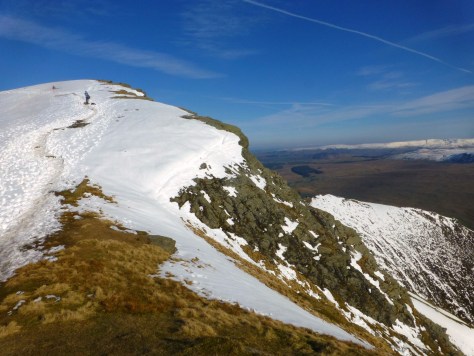
The Climbers’ Traverse and The Great Slab
Eventually what remains of a path turns away from the ravine to follow the stream of Busco Sike. When it’s narrow enough, I step across and make toward the towering summit. In the foreground are the first people I’ve seen since Stool End. They’re following the path from The Band which crosses to the col of Three Tarns and a well-trodden route to the peak.
But there’s a more dramatic way to reach the summit and it lies over the ridge in front. I cross the Three Tarns path and climb the open fell-side. After a short scramble, I join a higher, narrower path that takes me over the crest to the start of the Climbers’ Traverse.
The east face of Bow Fell comprises three sheer rock faces: Flat Crag, Cambridge Crag and Bowfell Buttress. The cliffs are precipitous and the slopes below drop steeply to the valley floor. Not a place to wander without ropes and climbing equipment you might think, but a narrow path leads across the foot of the crags, allowing the walker to venture where they otherwise might not. You need a reasonable head for heights as it does feel exposed but in dry conditions the going is easy and presents no real problems. I venture out on to the Climbers’ Traverse and the views take my breath away.
To my right, the Langdale Pikes are revealed in all their top-to-bottom glory; the conical peak of the Pike O’Stickle to the fore. Looking behind, the Pike O’Blisco rises over the ridge. Ahead, beyond the valley of Langstrath, distant Blencathra pierces the horizon. Everywhere, the sunlit winter landscape is a palette of warm ochre and purple shadow.


As I approach Flat Crag I have an eerie feeling I’m being watched. I look up to discover a striking rock formation striped with blue, red and purple quartz; above, the crags have eroded to resemble a giant pair of eyes and a long flat nose. Rock face indeed! If Hell Gill had put me in mind of an Inca temple, then Flat Crag is Easter Island. I start to wonder what it was I poured on my cereal this morning.

I later share some photos on Facebook and Fred James recounts how he fed a mouse some malt loaf on the Climbers’ Traverse when it was covered in deep snow. A place of magical encounters it seems.

The spring that perpetually gushes from the foot of Cambridge Crag feeds a small oasis of green. It also marks the exit. There’s no way up Bowfell Buttress without ropes, but a scrambly path leads up beside Cambridge Crag over a “river of boulders”. I start to climb. When I draw level with the top of Flat Crag, another striking feature unfurls: the huge slope of polished stone known as The Great Slab. It’s a magnificent sight and the views across it to the Langdale Pikes are staggering. Wandering away from the boulders and out into the middle could be a short lived pleasure, however. One slip and you might find yourself in Mickleden, earlier than planned and in a great many more pieces.

Summit
Reaching the top I look back over the Slab to Windermere glistening in the distance; then climb the remaining boulders to the summit.
“Is that Scafell Pike?”
“Yes”,
“And that’s Sca Fell?”
“Yes, it is”. I’ve been joined by a beaming young man in combat fatigues.
“And that’s Great Gable?”
“No I think that’s Great End”, (I’m wrong, it’s Esk Pike but I haven’t had a chance to check the map and it looks like the end of the Scafell massif).
“Is this Great Gable?”
“This that we’re standing on?”
“Aye.”
“No, this is Bow Fell.”
“Ah right, Bow Fell. I’ve come from ‘Cisco”,
“Do you mean The Pike O’Blisco?”
“Aye right enough”,
“Over Crinkle Crags”,
“Aye probably”.
My new companion tells how he drove from Dumfries and slept in his car to be on these hills at first light. He might be muddling names but I get the impression he knows roughly where he’s going; besides, he exudes such a boundless energy and enthusiasm that, even if he doesn’t, I feel sure he’ll get there.

Over a few more boulders to the summit cairn and the world converges. I’m almost grateful for the breeze that starts to chill – without it I might have sat here all day. Eventually I pull on my rucksack and head north toward Esk Pike. My new Scottish friend emerges from over the crags to my right where, thanks to my mis-identification, he’s been searching for that very fell. He laughs when I apologise and we chat as far as Ore Gap, where he heads on up the real Esk Pike and I turn right for Rossett Gill.

Smugglers’ Footsteps
When Bow Fell’s northern ridge falls away, Rossett Pike is revealed to my right over the blue waters of Angle Tarn. I follow the path down to the water’s edge. It looks so inviting I’m tempted to dive in, but these hills were under snow last week and I doubt the water’s warmed. Besides, there are people picnicking; the sight of me skinny dipping would put them off their sandwiches. Instead, I walk up to Rossett Pass and climb to the Pike’s summit, which affords a fascinating retrospective on my route.

Back at the pass, I follow the good, stone pitched path that zigzags down beside Rossett Gill, a welcome replacement for the steep stony slog that Wainwright describes in “The Southern Fells”. Intriguingly, Wainwright also mentions an old pony-route, believed to have been used to smuggle illicit goods from the port of Ravenglass.
Lanty Slee was a legendary Langdale smuggler. Officially, a farmer and quarryman during the early 1800’s, Slee’s main source of income came from the stills he had secreted around Little Langdale: one in Moss Bank Quarry; another beneath Low Arnside Farm. To divert attention, Slee connected the latter to a long underground pipe, doubtless prompting passers-by to puzzle why steam was rising from a hedge in the middle of a field.
Lanty sold his moonshine for 10 shillings a gallon, transporting the excess to Ravenglass and returning with contraband tobacco. He was convicted twice and kept the Ambleside courtroom well entertained with the wittiness of his defences. The excise men routinely failed to seize his whisky however, and some may even remain stashed in the caves around these crags.

When Chris Jesty revised Wainwright’s works, he insisted no trace of the old pony-route remained, but in an excellent blog that describes another way up Bow Fell, Martin Crookall gives some canny pointers on how to follow its course:
https://mbc1955.wordpress.com/2013/02/20/great-walks-crinkle-crags-bowfell-esk-pike/
With tired legs and the tempting prospect of a pint in the Old Dungeon Ghyll Hotel, I leave archaeology for another day and follow the stone steps to the valley floor. The final stretch through Mickleden leads beneath the Langdale Pikes and the steep southern scree slope of the Pike O’Stickle. A couple of indefatigable souls are attempting a direct ascent. My thoughts turn from a notional axis to Neolithic axes – but that’s another tale.

For a map of this route and detailed directions, visit Walk Lakes