The Mosedale Horseshoe and a Night at Black Sail
A tough but beautiful walk around the Mosedale Horseshoe takes in some of England’s finest mountain scenery and ends with a night at the country’s remotest youth hostel, deep in the wilds of Ennerdale. It begins by the shore of Wastwater, where the sight of divers kitting up in the car park, stirs memories of a notorious 80’s murder enquiry.
The Lady in the Lake
There’s something utterly wild about Wastwater. Forget the pastoral prettiness of Windermere or Coniston, England’s deepest lake is a feral beast; savagely beautiful but ever poised to bare its teeth. On this July morning, the sky is overcast and there’s a distinct chill in the breeze. The choppy waters are gun-barrel grey, rippled with white-crested waves; dark and inscrutable, daring you to guess at the secrets beneath.

In the wooded parking area beside Overbeck Bridge, two men are preparing to find out. As they don dry suits and all manner of sophisticated diving gear, Tim remarks they must reckon it’ll be seriously cold. One of the divers looks up and smiles, “yeah, at 40 metres down, the temperature stays pretty much the same all year round”.
40 metres is the limit for diving with compressed air. Below that, special suits and gas mixtures are needed to survive. For all the lake’s imagined mystery, what most divers find is an endless expanse of mud; or perhaps, if they’re lucky, the gnome garden, introduced by an enterprising soul to add a bit of novelty to the view.
On occasion, though, Wastwater has yielded darker secrets. In 1984, Neil Pritt was diving at a depth of 34 metres when he spied a rolled-up carpet tied to a concrete block. At first, he dismissed it as the efforts of an ambitious fly-tipper, but aware that police had recently searched the lake, looking for missing French fell-walker, Veronique Mireille Marre, Neil took a closer look. His suspicions were confirmed – the carpet concealed the body of a woman.
But it wasn’t Veronique. Whoever she was, she’d been down there some time. The cold had preserved her so well, it was only a matter of days before police made a positive ID. In the meantime, the press dubbed her “The Lady of the Lake”.
When investigators removed her wedding ring, it bore the inscription, “Margaret 15-11-63 Peter”. Detectives made the connection with the case of Margaret Hogg from Guildford, reported missing by her husband, Peter in 1976. Peter was arrested. Under interrogation, he capitulated and confessed to killing his wife but claimed extreme provocation. He told the Old Bailey how Margaret had been having an affair, which she made little effort to conceal. According to his testimony, on the night in question, Margaret tired of merely taunting her husband and physically attacked him. Peter retaliated by grabbing her by the throat and squeezing hard. When the life went out of her eyes, he stopped. When she slumped to the floor, he realised she was dead and coolly hatched a plan that very nearly proved the perfect crime.
After wrapping Margaret’s body in an old carpet, Peter put her in the boot of the car with a rubber dingy, a roll of carpet, and a concrete block. Then he drove through the night to Wastwater. Had Peter rowed out a few metres further, Margaret’s body would have fallen into the “abyss” and sunk all the way to the bottom, at nearly twice the depth a diver could reach. As it was, she came to rest on a shelf just under half way down, where she would remain for the next eight years.
I’m not sure what a modern jury would have made of Peter’s defence, but in 1984, a woman’s infidelity was enough to hand the moral high ground to the man. Peter was acquitted of murder and given three years for manslaughter, plus an extra year for obstructing the coroner and committing perjury in divorce proceedings.
Veronique’s body was later found at the bottom of Broken Rib Crag. The coroner returned an open verdict, but there was nothing to suggest that this was anything other than a tragic accident.
The Mosedale Horseshoe
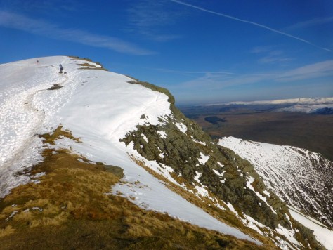
For all its brooding solitude, Wastwater is magnificently beautiful. The vista over lake, to the fells at its head, has been voted Britain’s favourite view. Great Gable takes centre stage, while in the foreground, resembling the hull of an upturned boat, stands Yewbarrow. Yewbarrow is the start of the Mosedale Horseshoe, an airy circuit that boasts some of the finest mountain scenery in Lakeland. Tim and I are going to walk the ridge to its highest point on Pillar. From there, we’ll descend into the wilds of neighbouring Ennerdale for a night at England’s remotest youth hostel – the Black Sail hut.
We leave the car park following the stream, cross a stile, and turn right on to a steep and unrelenting grass slope. Ahead is the formidable face of Bell Rib. There doesn’t appear to be a way up for mere mortals. Indeed, Wainwright declares it “unclimbable except by experts”, adding, “maps showing paths going straight over it are telling fibs”. Fortunately, the Ordnance Survey is less aspirational. Their route skirts left and climbs between Bell Rib and Dropping Crag. Such is the gradient, we’re looking for the fork long before we reach it.
The path ends abruptly at a steep, stone-filled gully. We put hand to rock and start to climb. At just over 2000 ft., Yewbarrow is the baby of the group, but it’s no mean mountain and won’t surrender its summit without a struggle.

At the top, a grass slope leads to a narrow ridge beyond Bell Rib. Behind us, Wastwater is a shimmer of silver beneath the whitening cloud. When we reach the crest, a dramatic cleft in the crags, known as The Great Door, frames a canvas of rich but sombre tones: the shadowed lake a dark sash of royal satin, deep and vivid blue; hemmed by the solemn Screes, their slopes mottled with daubs of gold and green, and deftly flecked with feathered brushstrokes, like copper flames that flicker up to kiss a scarf of purple heather.
Poised above the water’s edge, a dark vestigial verge of coppice, a lone patch of fur on an else clean-shaven pelt.
Cupped high among bottle-green spires, Burnmoor Tarn is a glint, a duck-egg glimmer, a hint of hidden brightness, cajoling the bashful sun to break cover.


A few easy rock steps remain between here and the summit. When we arrive, the panorama is remarkable; Pillar rises like barnacled leviathan from the mossy sea of Mosedale; sunlight gilds the green skirts of Kirk Fell and, to the east, the Roof of England is cloaked in cloud, Mickledore just visible through the mist like a gateway to Middle Earth.

Across a depression, we stride up Stirrup Crag and glimpse our onward path. Thin wisps of cloud float like wood smoke around the top of Red Pike. A faint path snakes through charcoal crags to a carpet of olive green above.
The way lies across Dore Head, some 300 feet below. If we’d studied the contours we’d have known the path that swung left, a little way back, was the easier proposition. As it is, we stick with the one we’re on and climb down the crag itself; descending abruptly through a maze of chimneys; easing down bulwarks on jagged ledges; stepping back from dead-ends that stop in sudden drops. It’s slow and a touch unnerving, but there’s only one sticky moment: a parapet I think I can shimmy down in two small stretches. But I misjudge. Now, over-committed, I’m obliged to jump – a little too far for comfort. Thankfully, I land well, with all extremities intact, and manage not to career over the next edge.
Once down, we’re slightly shocked at how severe Stirrup Crag looks from below and wonder if we’d have attempted it had we known. I later read that Wainwright left a trail of blood over these rocks and feel relieved they weren’t craving a fresh sacrifice. For some reason, Tim chooses now to mention that the Black Sail Youth Hostel cancellation policy includes a plea to the effect – “let us know if you are not coming. If we’re expecting you and you don’t show, we’ll send out Mountain Rescue.” I’m not sure whether it’s a comfort or a concern.
A party of around 15 fresh faced teenagers has arrived at Dore Head ahead of us. They took the sensible path. In fact, they may have bypassed Yewbarrow altogether. They’re now comfortably ensconced in a rest and refreshment break that looks set to extend indefinitely. If they’re going to tackle the full round at this rate, it could prove a very long day. I hope they’re not descending from here, though. The traditional way down to Mosedale is a notorious scree slope. Once the delight of scree runners, it’s now so dangerously eroded it looks concave from below. A grass rake offers an alternative but even that looks severe. I think of Veronique Marre and conclude some risks just aren’t worth taking; then try not to think about that as I look back over Stirrup Crag on the way up Red Pike.

Once on top, isolated shafts of sunlight steal through cracks in the cloud. Scoat Tarn sparkles to the south, the adamantine lustre of lost treasure, scattered in the bracken. Haycock is now in sight, while, northward, Great Gable rises over Kirk Fell, a pyramid no more, but a mighty dome, surged from the earth in an ancient eruption of volcanic violence. Beyond the summit, we perch on crags above Black Combe and eat pies, looking across to Pillar and the stiff stream of scree tapering to the col of Wind Gap.
Out of the breeze, it’s warm. Certainly, warm enough for midges to swarm around Tim. Apparently, he only had space in his rucksack for one bottle, so it was a toss-up between sun cream and midge repellent. He went with sun cream, which is probably why the sun has, so far, been so coy. Tim swears by a midge repellent that’s marketed by Avon as a moisturiser. It’s called Skin So Soft and whenever he produces a bottle, he feels compelled to assure me “it’s what the SAS use”. He retreats into the breeze and the midges turn on me, so I’m compelled to join him.
We climb the saddle to Scoat Fell and catch our first sight of Ennerdale Water, a pale sheen against the dense green of the pine plantations on its banks. The summit lies a little to our left and a fine ridge runs out to Steeple, which looks as inspiring as its name. It’s all too tempting for anyone with fire in their blood. But we’ll have fire in our bellies too and we still have some way to go before we reach Black Sail. Supper is served at seven, so to arrive ravenous and find we’d missed it would be miserable. There’s also that thing in the cancellation clause that convinces us to press on to Black Crags without detour. From there, we descend to Wind Gap and begin the tough pull up to Pillar. With the exertion, any residual disappointment at skipping Steeple turns to quiet relief.


Few labours reward so richly, however. As we reach the summit, the sun breaks through, illuminating the landscape in way that is nothing short of magical. Pillar Rock rises majestically above a sward of conifer; Great Gable is a tower of rugged glory; Broad Stand, finally free of cloud, a brutal bastion on the ramparts of Sca Fell. But as shafts of sunlight dance across the slopes, this terrain of intransigent rock manages to evoke nothing so much as a swirling Turner seascape: the white splashes of exposed rock are surf and spray; dark crags, the welling eddies; the wave upon wave of rolling peaks, a surging ocean, every shade of green.


All the way down to Looking Stead, I linger, attempting to capture this on camera. It’s beyond my skills and if I lavish words, it’s only to try and convey what pictures fail to tell.

At the top of Black Sail Pass, we meet a man who asks us if we’ve seen a party of 15 teenagers. They’re not late, he’s just bored of waiting. Something tells me he’s in for a long day.
Black Sail Hut
We descend into Ennerdale, where, in the remotest corner of this wildest of valleys, lies an old shepherd’s bothy: The Black Sail Hut, now a Youth Hostel and our home for the night. A warm welcome and cold beers await. We sit outside on wooden benches in the golden light of evening and watch the Galloway cattle, that roam free like big black bison, old as the hills.

Tim disappears for a shower and I watch a small figure wend her way down the long path from Windy Gap, between Great and Green Gable. When she arrives, she unshoulders her pack, grabs a beer and joins me outside. We compare notes on our routes. As we chat, I suddenly realise why she looks familiar. It’s Yvonne, a friend of my wife’s from about ten years ago. Yvonne is a high-powered consultant to head gardeners. I’ve only met her once, when she led a tour of the grounds in a Lakeland stately home, dispensing invaluable tricks and tips, some of which I wrote down and perpetually promise to put into practice. She asks about Sandy and we laugh out loud at the odds of meeting like this. Tim reappears around the corner, and the midges make a bee-line for him. Yvonne proffers a bottle of repellent. “Skin So Soft” he beams delightedly, then drops his voice an octave and adds “the SAS use it, you know”.


After supper, we sip beers and swap stories with two guys sharing our dorm. They’re old friends from London, who have moved out of the capital in different directions but meet up once or twice a year for walking holidays. They’ve been in the Lakes all week, tramping the hills and staying in hostels. There are three of them but the third has turned in for an early night. Unsurprisingly, he’s the first up in the morning. I join him for a coffee while we wait for breakfast. He tells me how they got a light soaking on top of Haystacks late yesterday afternoon.
“That’s odd” I say, “we were on Pillar around that time, looking down on Haystacks. It looked as if it was in sunshine.”
He looks puzzled, then shrugs, “perhaps it was earlier – three-ish possibly”. Very localised showers are possible in the hills, but it still doesn’t quite add up.
“We stayed at Honister Youth Hostel, last night”, he continues.
“No, you didn’t”, I shout (silently), “you stayed here. I’ve just seen you get out of bed”.
“We’ve been lucky today though”, he goes on, “it’s been dry all day”.
Incredulous, I want to scream, “It’s quarter to eight in the morning. You’ve not been anywhere yet and besides, it’s bucketing it down”… but then I realise, he’s just a day out. By “today”, he means “yesterday”, “yesterday” means the day before. Suddenly, everything makes sense. It’s pretty much the same account we got from his mates – you just have to subtract a day.
It’s an odd idiosyncrasy, but I can think of two possible explanations: he’s either a timelord or, after several consecutive days on the fells, the days begin to blur. I’ve been out for one night and I can already understand that.
Everything that seems so integral to our existence – the bustle of the working week, its routines, schedules, deadlines – simply dwindles in importance out here; it’s all fluster, all folly, all “sound and fury, signifying nothing”. Our own inflated sense of self-importance, seems equally ridiculous. Set against the timeless scale of this primal landscape, our hive and industry seem no more significant than the swarming of midges.

I scratch the bites and the simile suddenly seems poignant – we too do disproportionate damage. Wainwright called Ennerdale’s pine plantations an act of vandalism – a defacing of the indigenous landscape – but we do much worse than this. And with a climate change denier in the White House, efforts to curb our excesses are under threat.
In the 60’s, a NASA scientist called James Lovelock wrote a book called GAIA, in which he argues the Earth acts like a single living organism. Its ecosystems adapt and evolve to marginalise or eliminate threats. If he’s right, even now, the planet could be developing a natural strain of Skin So Soft to send us blighters packing.
My mind wanders back to the here and now where my new acquaintance is finishing his account. I conclude he’s a timelord and we refer to him thereafter as the Doctor.
With the cloud down and heavy rain set in, we abandon plans to climb Great Gable and head back over the Black Sail Pass. It’s an opportunity postponed, not lost, as one thing is certain. We’re coming back here.