The Nab & the Rut
In Martindale, it’s antlers at dawn as Britain’s largest land mammals fight for the right to party, and I pay a tribute to a sly old fox for inspiring me to walk The Far Eastern Fells.
On a chilly October morning, Ullswater is the colour of cold steel, ridged with dark ripples where it laps the jetty, a moody pool, carved from the frozen earth by a river of ice, and a keeper of mysteries. A small huddle of pilgrims has gathered on the pier at Glenridding, ready to set sail across its brooding waters in search of an ancient rite.

The red deer is the largest British land mammal; stags stand well over a metre at the shoulder and weigh up to 190Kg. 11,000 years ago, they came to Britain from Europe, and their meat, hides and antlers provided Mesolithic man with an important source of food, clothing and tools. With the advent of agriculture, much of their natural habitat was lost, and they disappeared from many parts of England, but they remained well-established in Scotland. The Victorians bolstered the population by cross-breeding them with wapiti and sika; numbers and distribution have increased ever since, but some pure-bred red deer herds still remain in England. The oldest inhabits the Martindale Deer Forest, which is maintained by the Dalemain estate as a sanctuary.
Autumn brings the breeding season, known as the rut. Between September and November, stags return to the females’ territory and do battle for the right to mate. It’s a winner takes all scenario, so testosterone levels run high. The victor gets to sow his seed throughout the herd, while the losers spend a celibate year drooling over pictures of pretty hinds, pouting provocatively from the pages of The National Geographic, distributed by gamekeepers to maintain their interest and prevent them from taking up alternative hobbies like stamp collecting or computer games. During the rut, the males establish dominance by roaring and strutting like Steve Tyler on steroids; but if that doesn’t work, they fight—sometimes, to the death.
The Deer Forest isn’t accessible without specific permission from the estate. Luckily, we’re on a special expedition arranged by the RSPB in conjunction with Ullswater Steamers, so clearance has been granted. As we board the steamer, I realise we’re a motley crew, clad in autumnal hides of microfleece and Gore-Tex; dominance appears to be established not by the size of antlers but by who has the biggest binoculars. And I’ve forgotten mine, so I’m already at the bottom of the pecking order.
As the steamer glides over primordial waters, the world of concrete and tarmac dissolves. An isolated shaft of sun embroids a bright golden braid on the sombre fell side below Helvellyn, and a sense that we’re venturing somewhere older, wilder, more primal pervades.

On the heather-clad slopes below Place Fell, belted Galloways graze; then a ripple of excitement runs through the boat as pair of antlers appears on the skyline. A slender stag makes a fleeting appearance. He’s only young—too small to entertain serious hopes of quenching his ardour this year.

An RSPB steward directs our attention to the crags above. He’s spotted a peregrine. Massed ranks of binoculars are raised in unison. My wife, Sandy, a professional photographer, aims a long telescopic lens. I fumble with the zoom on my little compact camera in an effort to join in. It comes as no surprise to anyone that I fail to spot it. The steward takes pity and lends me his eyeglasses. As a flock of ravens appears, he explains peregrines and ravens are arch-enemies. They compete for the same eyries, and ravens will often join forces to mob an invading falcon. I see an opportunity to improve my standing within the group as I’ve actually witnessed this. I recount standing on the summit of High Street, not far from the trig point, and hearing a raucous squawking overhead. I looked up to see a peregrine pulling ahead of pursuant mob of angry ravens, all apparently vying to peck at its tail feathers. The peregrine was much faster, and in a few wingbeats had gained a good lead, but just as I thought the action was over, it did something I wasn’t expecting. With a dazzling display of aerobatic agility, it performed a tumble-turn and sped back, like an Exocet missile, straight at the unfortunate raven it had ear-marked as victim. The ravens dispersed instantly, the target only just getting out of the way in time.
The steward nods knowingly. “Quite a spectacle that, isn’t it?”, he says with a grin. “I’ve seen it where the raven didn’t get away. It ended in a sickening thud and a flurry of black feathers.”


We disembark in Howtown, where a minibus awaits to ferry us up the hill to a track below Beda Fell, where three more stewards have set up telescopes: one pointing up the slope, and one pointing across to The Nab. I wait my turn on the latter. When it comes free, the steward directs my gaze to the lower slope where a large herd of hinds is encamped. It’s all very laid back: they’re lying down, basking in the autumn sunshine (or at least they would be, if there was any). The resident stag sits smugly amid his harem, awaiting challengers. He doesn’t seem overly concerned—probably because he’s the cervine equivalent of Arnold Schwarzenegger, a huge muscular brute with a formidable pair of antlers. Up wind, on the other side of a broken-down wall, are two young hopefuls. They’re recumbent too, desperate to keep out of Arnie’s sight while they summon the courage to take him on. I wouldn’t bet on that happening any time soon.
As we chat, the steward tells me they’ve be running these excursions for a few years. It hasn’t always gone to plan…
Since we wiped out the wolves and bears that once roamed our forests, the red deer have no natural predators. If left unchecked, their numbers would grow unnaturally large, and the health of the herd would suffer. As a consequence, some culling is necessary. It’s a fact that doesn’t sit well with those of a sensitive disposition, but on balance, having the free run of Martindale and taking your chances, occasionally, with a skilled gamekeeper armed with a rifle and a remit to reduce numbers by removing the weakest, sounds a better deal to me than being cooped up on an intensive farm, then being shipped to the abattoir. I don’t know whether the Dalemain Estate offers paying clientele the opportunity to shoot deer for sport, and quite why anyone would take pleasure in killing such magnificent creatures is utterly beyond me. I have no issue with humane culling, or with killing animals to eat, but if I had to do it, I’d be choking back the tears.
…As such, I can fully imagine the horror of the nature lovers who took this trip, a year or two back, and heard shots, then had to stand aside for an estate quad bike towing the blood-spattered carcass of a hind. (Consequent discussions between the estate and the RSPB have resulted in a less distressing coordination of activities.)
It’s all hotting up on Beda Fell where another herd is grazing. Their stag is similarly reposed, but perhaps, not for long. A young contender has appeared on the skyline. He’s sniffing the air and assessing the situation. I take my turn on the telescope. A girl in an RSPB jacket asks me if I have an iPhone. She explains it’s possible to point your phone’s camera at the telescope’s eyepiece and get a reasonable close-up picture. I try, but all I can see is a ball of white light.
“Follow the light”, she explains, “and when you’ve got it centred, take the pic”.
It’s a lot harder than it sounds. She smiles sympathetically and asks if I’d like her to have a go. She takes my phone, waves it at the eyepiece for a couple of seconds and skilfully snaps the stag.
“There’s a knack”, she says with a smile. “I’ve had a lot of practice”.

Suddenly, the young male starts down the slope. The action causes a commotion in the herd and the incumbent stag jumps up to meet his challenger. He’s even bigger than Arnie. The young contender takes one look and suddenly remembers he might have left the gas on. He tries to slink away nonchalantly, as if this was his intention all along, and those hinds? Just not his type. We don’t have to be budding David Attenboroughs to realise we’re unlikely to see locked antlers today. It matters little. Just being in the presence of these majestic creatures is edifying.
~
A year later, I’ll climb Rough Crag on High Street to a cacophony of red stag roars, the wind lifting their war song out of Martindale and into the peaks where it resonates around the crags that surround Blea Water and Riggindale, disembodied and amplified, the bloodcurdling battle cry of invisible duellists, berserk with hormonal rage.
It’ll be another nine months, before I stand on the summit of The Nab…
~
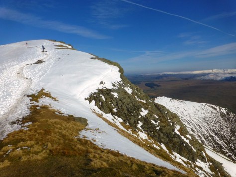
I set out later than usual, hoping to give low cloud a chance to lift. I park in Hartsop, round Gray Crag and follow the stream up to Hayeswater to climb the slopes below the Knott. I’m heading for Brock Crags and Angletarn Pikes, but I can’t resist bagging three more Wainwrights first. As I reach the summit of the Knott, a wispy veil hides High Street’s upper reaches, but to the north, the low white blanket has cleared Rest Dodd.
Beyond lies The Nab. As Wainwright astutely notes: from below, it resembles the cluster of Dodds that ring the head of Ullswater. Its steep sides rise to a slender dome, with Rest Dodd a second hump, like the back of a Bactrian camel. From above, however, you realise Rest Dodd is the Daddy, and the Nab, no more than an impressive façade.


Down the ridge from the Knott, I turn up Rest Dodd’s grassy slopes. As The Nab sits entirely within the deer sanctuary, there’s no direct public access from below. The top, however, is open access land, so you can legally gain the summit from here. That said, there are conditions. The Dalemain website suggests: “the area may be closed at times between September and February for deer management and possibly at other times as required. To avoid any disappointment it is important to check that access will be available before your visit.”
It’s a request worth following for your own sake, as well as for that of the deer—it may save you from being skewered by a randy stag or shot by a stray stalker’s bullet. Unfortunately, I didn’t know this at the time so plead ignorance as my defence.
What deters most walkers from crossing to The Nab is the substantial peat bog that lurks in between; AW describes it as “one of the worst in Lakeland”. I hate boggy ground and derive no pleasure from picking a painstaking path across a soggy morass, testing every step and somehow still ending up with bootfuls of black water. Luckily for me, it’s mid-July and Lakeland is in the middle of a prolonged drought. The deep peat hags are bone dry, and I cross without so much as a damp sole.
On the summit, I see no deer, but I do acknowledge a debt to Wainwright—not just for fuelling a fledging passion with sketches that perfectly capture the character of each fell; not just for his flights of poetic eulogy and stabs of wicked humour; but also, for his diligence and detail in dividing these hills into coherent clusters and devoting a book to each. The majority of my walks in the past twelve months have been devoted to the Eastern and, particularly, the Far Eastern Fells. Looking out from here, I relive a year: Rampsgill Head and High Raise in the amber light of autumn; Steel Knotts, Wether Hill, Loadpot Hill, Arthur’s Pike and Bonscale Pike in baking June sunshine, sweetened by a summer breeze. To the west is Beda Fell, and the site of the RSPB excursion.

In a while, I’ll look out from Brock Crags over Pasture Beck and remember the start of spring on Stony Cove Pike (before a dicey descent, down frozen rock steps to Threshthwaite Mouth, suggested winter hadn’t quite departed); or sheltering from a biting breeze behind the Thornthwaite Beacon and breaking a trekking pole on the steep wet grass of Gray Crag. From Angletarn Pikes, I’ll recall the Dovedale round in snow, when the air was as crisp and new as the year.


I’m not short of mementos, I have photos, I have blogs, but while I’m able, I shall never tire of renewing my relationship with these summits. I’ve heard people lament finishing the Wainwrights and wonder what to do next. Come back! They’re never done. Do you imagine they suffer diminishing returns? There’s a man who walks the Old Man of Coniston every day. And every day, he gains something new from the experience.
So inevitably, I’ll return to The Nab. Perhaps next time, I’ll ask permission; but I will stick to the Rest Dodd route; direct ascents from the deer sanctuary are out of bounds for good reason. The animal lover, Wainwright, makes the plea, “PLEASE DO NOT INTRUDE”, beside a sketch of a stag.
Only, where Wainwright is concerned, it’s rather a case of do as I say and not as I do—as the sly old fox adds this:
“The author carried out his explorations surreptitiously, and without permission (not caring to risk a refusal); he was not detected, but this may possibly have been due to his marked resemblance to an old stag, and other trespassers must not expect the same good fortune. Walkers in general should keep away. The keen ‘peak-bagger’ who is ‘collecting’ summits over 1886’ must settle the matter with his conscience, and, if he decides he cannot omit The Nab, he may best approach it unobtrusively (but with permission) by way of the ridge from Rest Dodd, returning the same way. The following notes on direct ascents will therefore be of little interest to anybody but deer with a poor sense of direction.”

Sources/Further reading
The British Deer Society (2015). ‘Red Deer’. Available at:
https://www.bds.org.uk/index.php/advice-education/species/red-deer (Accessed Sept 2018)
Richards, Mark (2014). ‘Park and Stride—The Martindale Skyline’. BBC Cumbria, November. Available at:
http://www.bbc.co.uk/cumbria/content/articles/2006/07/21/parkandstride_8_martindale_feature.shtml (Accessed Sept 2018)
Wainwright, A. 1957: A Pictorial Guide to the Lakeland Fells—Book Two, The Far Eastern Fells. 50th Anniversary Edition. London: Frances Lincoln, 2005.
+ the imperfect memory of the author, which may, at times, be prone to flights of poetic fancy.
Practical note:
I believe the Dalemain Estate is now more amenable to granting permission than perhaps it was in Wainwright’s day. Their web site even gives details of permitted routes from Martindale (although you must phone first). For details and contact numbers, visit:
https://www.dalemain.com/house-and-garden/the-nab/